![](/images/other/stat-length.png)
![Tour Wandern Roche-Saint-Secret-Béconne - Roche St Secret - Le Rachas 12km - Photo](https://media.geolcdn.com/t/1900/400/268b8b7b-a801-49fb-8d44-e785e2e3eadd.jpg&format=pjpeg&maxdim=2)
Roche St Secret - Le Rachas 12km
thonyc
Benutzer GUIDE
![Länge](/images/other/stat-length.png)
Länge
12 km
![Maximale Höhe](https://static1.geolcdn.com/siteimages/upload/files/1508320355ic_sort_altitude_max_24dp.png)
Maximale Höhe
894 m
![Positive Höhendifferenz](https://static1.geolcdn.com/siteimages/upload/files/1508320355ic_sort_den_pos_24dp.png)
Positive Höhendifferenz
608 m
![Km-Effort](/images/other/stat-length.png)
Km-Effort
20 km
![Min. Höhe](https://static1.geolcdn.com/siteimages/upload/files/1508320355ic_sort_altitude_min_24dp.png)
Min. Höhe
379 m
![Negative Höhendifferenz](https://static1.geolcdn.com/siteimages/upload/files/1508320355ic_sort_den_neg_24dp.png)
Negative Höhendifferenz
608 m
![Boucle](https://static1.geolcdn.com/siteimages/upload/files/16400158638029165_repeat_loop_refresh_sync_direction_icon.png)
Boucle
Ja
Erstellungsdatum :
2021-05-06 07:52:53.505
Letzte Änderung :
2021-05-06 15:42:16.933
![Wandern](https://static1.geolcdn.com/sitytour/trail-icons/101.png)
4h00
Schwierigkeit : Medium
![Scannen Sie diesen QR-Code, um die Tour in der SityTrail-Anwendung zu öffnen](https://capi.geolives.com/qq0zvz2zws4bq2lad0pu/sitytour/trails/2775576/qr.png?size=200)
Kostenlosegpshiking-Anwendung
Über SityTrail
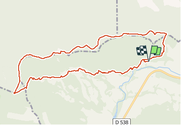
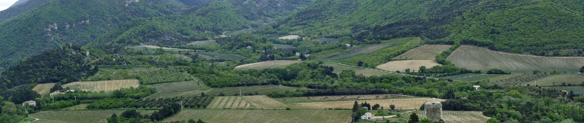
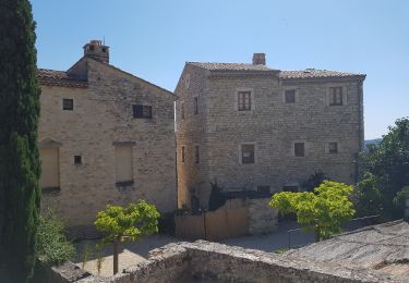
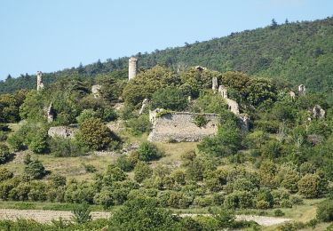
Tour Wandern von 12 km verfügbar auf Auvergne-Rhone-Alpen, Drôme, Roche-Saint-Secret-Béconne. Diese Tour wird von thonyc vorgeschlagen.
Beschreibung
Très belle rando.
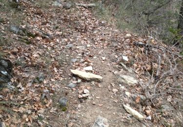
Entre le départ et la tour d'Alençon, la trace gps est calée sur le balisage PR. Ce sentier n'existe pas sur la carte IGN.
Ort
Land:
France
Region :
Auvergne-Rhone-Alpen
Abteilung/Provinz :
Drôme
Kommune :
Roche-Saint-Secret-Béconne
Standort:
Unknown
Gehen Sie:(Dec)
Gehen Sie:(UTM)
662364 ; 4929463 (31T) N.
Kommentare
Touren in der Umgebung
![Tour Wandern Montjoux - Le Devès - Montjoux - Photo](https://media.geolcdn.com/t/375/260/ext.jpg?maxdim=2&url=https%3A%2F%2Fservices.sitytrail.com%2FGeolivesWS%2FDownloadMedia.ashx%3FTrailID%3D172804%26Media%3D14234_5.jpg)
![Wandern Wandern](https://static1.geolcdn.com/sitytour/trail-icons/101.png)
Le Devès - Montjoux
Wandern
Einfach
(1)
Montjoux,
Auvergne-Rhone-Alpen,
Drôme,
France
![](/images/other/stat-length.png)
5,3 km | 7 km-effort
1h 19min
![](https://static1.geolcdn.com/siteimages/upload/files/16400158638029165_repeat_loop_refresh_sync_direction_icon.png)
Ja
![Tour Wandern Dieulefit - 26 dieulefit chap st Maurice vitrouilleres - Photo](https://media.geolcdn.com/t/375/260/9032ba92-359b-417c-8863-3a326ab807ba.jpg&format=jpg&maxdim=2)
![Wandern Wandern](https://static1.geolcdn.com/sitytour/trail-icons/101.png)
26 dieulefit chap st Maurice vitrouilleres
Wandern
Einfach
Dieulefit,
Auvergne-Rhone-Alpen,
Drôme,
France
![](/images/other/stat-length.png)
13,8 km | 23 km-effort
6h 17min
![](https://static1.geolcdn.com/siteimages/upload/files/16400158638029165_repeat_loop_refresh_sync_direction_icon.png)
Ja
![Tour Wandern Le Poët-Laval - Poët-Laval Les vitrouilléres (La Dame Blanche) 9km. - Photo](https://media.geolcdn.com/t/375/260/aa6f7aee-41bd-433a-b904-1eda7a964ff6.jpg&format=jpg&maxdim=2)
![Wandern Wandern](https://static1.geolcdn.com/sitytour/trail-icons/101.png)
Poët-Laval Les vitrouilléres (La Dame Blanche) 9km.
Wandern
Medium
Le Poët-Laval,
Auvergne-Rhone-Alpen,
Drôme,
France
![](/images/other/stat-length.png)
8,7 km | 11,5 km-effort
2h 37min
![](https://static1.geolcdn.com/siteimages/upload/files/16400158638029165_repeat_loop_refresh_sync_direction_icon.png)
Ja
![Tour Wandern Le Poët-Laval - Le Poet Laval : Le Trou du Furet 6km5 - Photo](https://media.geolcdn.com/t/375/260/e856c3d2-cc59-44f2-9430-12ee63613b6b.jpg&format=jpg&maxdim=2)
![Wandern Wandern](https://static1.geolcdn.com/sitytour/trail-icons/101.png)
Le Poet Laval : Le Trou du Furet 6km5
Wandern
Schwierig
Le Poët-Laval,
Auvergne-Rhone-Alpen,
Drôme,
France
![](/images/other/stat-length.png)
6,4 km | 12,9 km-effort
2h 55min
![](https://static1.geolcdn.com/siteimages/upload/files/16400158638029165_repeat_loop_refresh_sync_direction_icon.png)
Ja
![Tour Wandern Dieulefit - 2022-09-03_11h50m30_Chapelle St Maurice 10km.gpx (3).xml - Photo](https://media.geolcdn.com/t/375/260/70a2cb51-e6fc-4007-ba36-e4a050e05f72.jpg&format=jpg&maxdim=2)
![Wandern Wandern](https://static1.geolcdn.com/sitytour/trail-icons/101.png)
2022-09-03_11h50m30_Chapelle St Maurice 10km.gpx (3).xml
Wandern
Schwierig
Dieulefit,
Auvergne-Rhone-Alpen,
Drôme,
France
![](/images/other/stat-length.png)
10 km | 17,1 km-effort
3h 53min
![](https://static1.geolcdn.com/siteimages/upload/files/16400158638029165_repeat_loop_refresh_sync_direction_icon.png)
Ja
![Tour Wandern Roche-Saint-Secret-Béconne - 26montjoux - Photo](https://media.geolcdn.com/t/375/260/a6833288-f9f8-48b3-afa2-e10324484402.jpg&format=jpg&maxdim=2)
![Wandern Wandern](https://static1.geolcdn.com/sitytour/trail-icons/101.png)
26montjoux
Wandern
Medium
Roche-Saint-Secret-Béconne,
Auvergne-Rhone-Alpen,
Drôme,
France
![](/images/other/stat-length.png)
13,6 km | 22 km-effort
6h 6min
![](https://static1.geolcdn.com/siteimages/upload/files/16400158638029165_repeat_loop_refresh_sync_direction_icon.png)
Nein
![Tour Wandern Le Poët-Laval - Le poët laval - Photo](https://media.geolcdn.com/t/375/260/ext.jpg?maxdim=2&url=https%3A%2F%2Fstatic1.geolcdn.com%2Fsiteimages%2Fupload%2Ffiles%2F1553511878bg_sport_marche.png)
![Wandern Wandern](https://static1.geolcdn.com/sitytour/trail-icons/101.png)
Le poët laval
Wandern
Medium
(1)
Le Poët-Laval,
Auvergne-Rhone-Alpen,
Drôme,
France
![](/images/other/stat-length.png)
9,8 km | 17,8 km-effort
4h 21min
![](https://static1.geolcdn.com/siteimages/upload/files/16400158638029165_repeat_loop_refresh_sync_direction_icon.png)
Ja
![Tour Wandern Le Poët-Laval - le Poët-Laval et le trou du furet - Photo](https://media.geolcdn.com/t/375/260/ext.jpg?maxdim=2&url=https%3A%2F%2Fservices.sitytrail.com%2FGeolivesWS%2FDownloadMedia.ashx%3FTrailID%3D996556%26Media%3Dfix__20180630161904.jpg)
![Wandern Wandern](https://static1.geolcdn.com/sitytour/trail-icons/101.png)
le Poët-Laval et le trou du furet
Wandern
Sehr leicht
Le Poët-Laval,
Auvergne-Rhone-Alpen,
Drôme,
France
![](/images/other/stat-length.png)
7,5 km | 14,3 km-effort
4h 3min
![](https://static1.geolcdn.com/siteimages/upload/files/16400158638029165_repeat_loop_refresh_sync_direction_icon.png)
Ja
![Tour Wandern Roche-Saint-Secret-Béconne - 2024-11-08_07h25m28_La_Roche_Saint_Secret_par_la_Tour_d_Alencon_et_les_Ruines_de_Beconne - Photo](https://media.geolcdn.com/t/375/260/03c83edb-ebec-4386-95bd-750d45047f97.jpg&format=jpg&maxdim=2)
![Wandern Wandern](https://static1.geolcdn.com/sitytour/trail-icons/101.png)
2024-11-08_07h25m28_La_Roche_Saint_Secret_par_la_Tour_d_Alencon_et_les_Ruines...
Wandern
Schwierig
Roche-Saint-Secret-Béconne,
Auvergne-Rhone-Alpen,
Drôme,
France
![](/images/other/stat-length.png)
11,8 km | 15,4 km-effort
3h 30min
![](https://static1.geolcdn.com/siteimages/upload/files/16400158638029165_repeat_loop_refresh_sync_direction_icon.png)
Ja