![](/images/other/stat-length.png)
![Tour Wandern Vexin-sur-Epte - Aveny, Dampsmesnil, L'allée couverte - Photo](https://media.geolcdn.com/t/1900/400/ext.pjpeg?maxdim=2&url=https%3A%2F%2Fstatic1.geolcdn.com%2Fsiteimages%2Fupload%2Ffiles%2F1553511878bg_sport_marche.png)
Aveny, Dampsmesnil, L'allée couverte
Marie-Claire-mcp
Benutzer
![Länge](/images/other/stat-length.png)
Länge
10 km
![Maximale Höhe](https://static1.geolcdn.com/siteimages/upload/files/1508320355ic_sort_altitude_max_24dp.png)
Maximale Höhe
139 m
![Positive Höhendifferenz](https://static1.geolcdn.com/siteimages/upload/files/1508320355ic_sort_den_pos_24dp.png)
Positive Höhendifferenz
201 m
![Km-Effort](/images/other/stat-length.png)
Km-Effort
12,7 km
![Min. Höhe](https://static1.geolcdn.com/siteimages/upload/files/1508320355ic_sort_altitude_min_24dp.png)
Min. Höhe
37 m
![Negative Höhendifferenz](https://static1.geolcdn.com/siteimages/upload/files/1508320355ic_sort_den_neg_24dp.png)
Negative Höhendifferenz
204 m
![Boucle](https://static1.geolcdn.com/siteimages/upload/files/16400158638029165_repeat_loop_refresh_sync_direction_icon.png)
Boucle
Ja
Erstellungsdatum :
2021-04-30 12:50:29.294
Letzte Änderung :
2021-04-30 12:54:31.35
![Wandern](https://static1.geolcdn.com/sitytour/trail-icons/101.png)
2h52
Schwierigkeit : Schwierig
![Scannen Sie diesen QR-Code, um die Tour in der SityTrail-Anwendung zu öffnen](https://capi.geolives.com/qq0zvz2zws4bq2lad0pu/sitytour/trails/2767295/qr.png?size=200)
Kostenlosegpshiking-Anwendung
Über SityTrail
Tour Wandern von 10 km verfügbar auf Normandie, Eure, Vexin-sur-Epte. Diese Tour wird von Marie-Claire-mcp vorgeschlagen.
Beschreibung
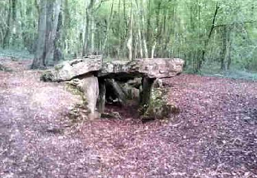
Depart Aveny, route à droite après le cimetière, puis à la sortie d'Aveny prendre un chemin sur la gauche, puis sur la droite, au bout, rue principale de Dampsmesnil, puis un chemin sur la droite jusqu'à L'allée couverte et bois des petits Aulnays et retour Aveny.
Ort
Land:
France
Region :
Normandie
Abteilung/Provinz :
Eure
Kommune :
Vexin-sur-Epte
Standort:
Dampsmesnil
Gehen Sie:(Dec)
Gehen Sie:(UTM)
402381 ; 5446653 (31U) N.
Kommentare
Touren in der Umgebung
![Tour Wandern Château-sur-Epte - Château sur Epte - Berthenonville - Photo](https://media.geolcdn.com/t/375/260/ext.jpg?maxdim=2&url=https%3A%2F%2Fservices.sitytrail.com%2FGeolivesWS%2FDownloadMedia.ashx%3FTrailID%3D891370%26Media%3D28f306c4-ccd7-4e45-8d5f-378c794acdd1.jpg)
![Wandern Wandern](https://static1.geolcdn.com/sitytour/trail-icons/101.png)
Château sur Epte - Berthenonville
Wandern
Einfach
(1)
Château-sur-Epte,
Normandie,
Eure,
France
![](/images/other/stat-length.png)
7,8 km | 9,5 km-effort
2h 7min
![](https://static1.geolcdn.com/siteimages/upload/files/16400158638029165_repeat_loop_refresh_sync_direction_icon.png)
Ja
![Tour Wandern Château-sur-Epte - Château sur Epte - Rollon Nord - Photo](https://media.geolcdn.com/t/375/260/ext.jpg?maxdim=2&url=https%3A%2F%2Fservices.sitytrail.com%2FGeolivesWS%2FDownloadMedia.ashx%3FTrailID%3D158414%26Media%3Df92478f2-a815-4319-b098-de4877cf6291.jpg)
![Wandern Wandern](https://static1.geolcdn.com/sitytour/trail-icons/101.png)
Château sur Epte - Rollon Nord
Wandern
Einfach
(1)
Château-sur-Epte,
Normandie,
Eure,
France
![](/images/other/stat-length.png)
8,4 km | 10,2 km-effort
2h 2min
![](https://static1.geolcdn.com/siteimages/upload/files/16400158638029165_repeat_loop_refresh_sync_direction_icon.png)
Ja
![Tour Wandern Buhy - De Buchet à Magny en Vexin - Photo](https://media.geolcdn.com/t/375/260/1020b94f-166d-40ac-8266-f51a3f0e5d45.jpg&format=jpg&maxdim=2)
![Wandern Wandern](https://static1.geolcdn.com/sitytour/trail-icons/101.png)
De Buchet à Magny en Vexin
Wandern
Medium
Buhy,
Île-de-France,
Val-d'Oise,
France
![](/images/other/stat-length.png)
25 km | 29 km-effort
5h 3min
![](https://static1.geolcdn.com/siteimages/upload/files/16400158638029165_repeat_loop_refresh_sync_direction_icon.png)
Nein
![Tour Wandern Vexin-sur-Epte - Château sur Epte variante par pierre tournante - Photo](https://media.geolcdn.com/t/375/260/ext.jpg?maxdim=2&url=https%3A%2F%2Fstatic1.geolcdn.com%2Fsiteimages%2Fupload%2Ffiles%2F1553511878bg_sport_marche.png)
![Wandern Wandern](https://static1.geolcdn.com/sitytour/trail-icons/101.png)
Château sur Epte variante par pierre tournante
Wandern
Einfach
(1)
Vexin-sur-Epte,
Normandie,
Eure,
France
![](/images/other/stat-length.png)
9,8 km | 12,1 km-effort
2h 30min
![](https://static1.geolcdn.com/siteimages/upload/files/16400158638029165_repeat_loop_refresh_sync_direction_icon.png)
Ja
![Tour Wandern Vexin-sur-Epte - Rando Douce 1 - Ecos - Photo](https://media.geolcdn.com/t/375/260/ext.jpg?maxdim=2&url=https%3A%2F%2Fstatic1.geolcdn.com%2Fsiteimages%2Fupload%2Ffiles%2F1553511878bg_sport_marche.png)
![Wandern Wandern](https://static1.geolcdn.com/sitytour/trail-icons/101.png)
Rando Douce 1 - Ecos
Wandern
Einfach
(1)
Vexin-sur-Epte,
Normandie,
Eure,
France
![](/images/other/stat-length.png)
6,5 km | 7,6 km-effort
1h 28min
![](https://static1.geolcdn.com/siteimages/upload/files/16400158638029165_repeat_loop_refresh_sync_direction_icon.png)
Ja
![Tour Wandern Vexin-sur-Epte - Ecos - les trois boucles court - Photo](https://media.geolcdn.com/t/375/260/ext.jpg?maxdim=2&url=https%3A%2F%2Fstatic1.geolcdn.com%2Fsiteimages%2Fupload%2Ffiles%2F1553511878bg_sport_marche.png)
![Wandern Wandern](https://static1.geolcdn.com/sitytour/trail-icons/101.png)
Ecos - les trois boucles court
Wandern
Einfach
(2)
Vexin-sur-Epte,
Normandie,
Eure,
France
![](/images/other/stat-length.png)
11,1 km | 13,1 km-effort
2h 51min
![](https://static1.geolcdn.com/siteimages/upload/files/16400158638029165_repeat_loop_refresh_sync_direction_icon.png)
Ja
![Tour Wandern Omerville - omerville et alentours - Photo](https://media.geolcdn.com/t/375/260/ext.jpg?maxdim=2&url=https%3A%2F%2Fstatic1.geolcdn.com%2Fsiteimages%2Fupload%2Ffiles%2F1553511878bg_sport_marche.png)
![Wandern Wandern](https://static1.geolcdn.com/sitytour/trail-icons/101.png)
omerville et alentours
Wandern
Einfach
(3)
Omerville,
Île-de-France,
Val-d'Oise,
France
![](/images/other/stat-length.png)
12,7 km | 16 km-effort
3h 17min
![](https://static1.geolcdn.com/siteimages/upload/files/16400158638029165_repeat_loop_refresh_sync_direction_icon.png)
Ja
![Tour Wandern Vexin-sur-Epte - Berthenonville Dampsmesni la côte aux chiens - Photo](https://media.geolcdn.com/t/375/260/ext.jpg?maxdim=2&url=https%3A%2F%2Fstatic1.geolcdn.com%2Fsiteimages%2Fupload%2Ffiles%2F1553511878bg_sport_marche.png)
![Wandern Wandern](https://static1.geolcdn.com/sitytour/trail-icons/101.png)
Berthenonville Dampsmesni la côte aux chiens
Wandern
Medium
(1)
Vexin-sur-Epte,
Normandie,
Eure,
France
![](/images/other/stat-length.png)
9,5 km | 12,7 km-effort
2h 16min
![](https://static1.geolcdn.com/siteimages/upload/files/16400158638029165_repeat_loop_refresh_sync_direction_icon.png)
Ja
![Tour Wandern Montreuil-sur-Epte - Montreuil sur Epte La Chapelle en Vexin - Photo](https://media.geolcdn.com/t/375/260/ext.jpg?maxdim=2&url=https%3A%2F%2Fstatic1.geolcdn.com%2Fsiteimages%2Fupload%2Ffiles%2F1553511878bg_sport_marche.png)
![Wandern Wandern](https://static1.geolcdn.com/sitytour/trail-icons/101.png)
Montreuil sur Epte La Chapelle en Vexin
Wandern
Schwierig
(1)
Montreuil-sur-Epte,
Île-de-France,
Val-d'Oise,
France
![](/images/other/stat-length.png)
11,1 km | 13,6 km-effort
3h 48min
![](https://static1.geolcdn.com/siteimages/upload/files/16400158638029165_repeat_loop_refresh_sync_direction_icon.png)
Ja