![](/images/other/stat-length.png)
![Tour Zu Fuß Saint-Aubin-des-Coudrais - grand tour de St Aubin - Photo](https://media.geolcdn.com/t/1900/400/ext.pjpeg?maxdim=2&url=https%3A%2F%2Fstatic1.geolcdn.com%2Fsiteimages%2Fupload%2Ffiles%2F1545311037marcheuse_200dpi.jpg)
grand tour de St Aubin
darkpapa
Benutzer
![Länge](/images/other/stat-length.png)
Länge
27 km
![Maximale Höhe](https://static1.geolcdn.com/siteimages/upload/files/1508320355ic_sort_altitude_max_24dp.png)
Maximale Höhe
182 m
![Positive Höhendifferenz](https://static1.geolcdn.com/siteimages/upload/files/1508320355ic_sort_den_pos_24dp.png)
Positive Höhendifferenz
371 m
![Km-Effort](/images/other/stat-length.png)
Km-Effort
32 km
![Min. Höhe](https://static1.geolcdn.com/siteimages/upload/files/1508320355ic_sort_altitude_min_24dp.png)
Min. Höhe
91 m
![Negative Höhendifferenz](https://static1.geolcdn.com/siteimages/upload/files/1508320355ic_sort_den_neg_24dp.png)
Negative Höhendifferenz
370 m
![Boucle](https://static1.geolcdn.com/siteimages/upload/files/16400158638029165_repeat_loop_refresh_sync_direction_icon.png)
Boucle
Ja
Erstellungsdatum :
2021-04-29 16:05:18.832
Letzte Änderung :
2024-08-23 10:52:58.739
![Zu Fuß](https://static1.geolcdn.com/sitytour/trail-icons/100.png)
7h19
Schwierigkeit : Schwierig
![Mountainbike](https://static1.geolcdn.com/sitytour/trail-icons/202.png)
2h14
Schwierigkeit : Schwierig
![Scannen Sie diesen QR-Code, um die Tour in der SityTrail-Anwendung zu öffnen](https://capi.geolives.com/qq0zvz2zws4bq2lad0pu/sitytour/trails/2766602/qr.png?size=200)
Kostenlosegpshiking-Anwendung
Über SityTrail
Tour Zu Fuß von 27 km verfügbar auf Pays de la Loire, Sarthe, Saint-Aubin-des-Coudrais. Diese Tour wird von darkpapa vorgeschlagen.
Beschreibung
parcours sur 3 communes : St Aubin des Coudrais,La Bosse et St Martin des monts présentant diffèrent type de sol ,caillouteux , gras , humide :exigeant
Ort
Land:
France
Region :
Pays de la Loire
Abteilung/Provinz :
Sarthe
Kommune :
Saint-Aubin-des-Coudrais
Standort:
Unknown
Gehen Sie:(Dec)
Gehen Sie:(UTM)
320683 ; 5338242 (31U) N.
Kommentare
Touren in der Umgebung
![Tour Wandern Saint-Georges-du-Rosay - Rosay et Jugeaux - Photo](https://media.geolcdn.com/t/375/260/af2a8428-78e5-4006-865e-2bb77d77453a.jpg&format=jpg&maxdim=2)
![Wandern Wandern](https://static1.geolcdn.com/sitytour/trail-icons/101.png)
Rosay et Jugeaux
Wandern
Medium
Saint-Georges-du-Rosay,
Pays de la Loire,
Sarthe,
France
![](/images/other/stat-length.png)
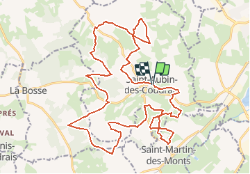
9,7 km | 11,2 km-effort
2h 32min
![](https://static1.geolcdn.com/siteimages/upload/files/16400158638029165_repeat_loop_refresh_sync_direction_icon.png)
Ja
![Tour Zu Fuß Saint-Aubin-des-Coudrais - St Aubin PR-9 long - Photo](https://media.geolcdn.com/t/375/260/5f6a8ce7-273e-4af3-9419-d645631065c3.jpg&format=jpg&maxdim=2)
![Zu Fuß Zu Fuß](https://static1.geolcdn.com/sitytour/trail-icons/100.png)
St Aubin PR-9 long
Zu Fuß
Medium
Saint-Aubin-des-Coudrais,
Pays de la Loire,
Sarthe,
France
![](/images/other/stat-length.png)
13,6 km | 16,4 km-effort
3h 42min
![](https://static1.geolcdn.com/siteimages/upload/files/16400158638029165_repeat_loop_refresh_sync_direction_icon.png)
Ja
![Tour Wandern La Ferté-Bernard - St Symphorien - Photo](https://media.geolcdn.com/t/375/260/ext.jpg?maxdim=2&url=https%3A%2F%2Fstatic1.geolcdn.com%2Fsiteimages%2Fupload%2Ffiles%2F1553511878bg_sport_marche.png)
![Wandern Wandern](https://static1.geolcdn.com/sitytour/trail-icons/101.png)
St Symphorien
Wandern
Schwierig
La Ferté-Bernard,
Pays de la Loire,
Sarthe,
France
![](/images/other/stat-length.png)
10,2 km | 12,2 km-effort
2h 47min
![](https://static1.geolcdn.com/siteimages/upload/files/16400158638029165_repeat_loop_refresh_sync_direction_icon.png)
Ja
![Tour Wandern Villaines-la-Gonais - le brame des cerfs - Photo](https://media.geolcdn.com/t/375/260/ext.jpg?maxdim=2&url=https%3A%2F%2Fstatic1.geolcdn.com%2Fsiteimages%2Fupload%2Ffiles%2F1553511878bg_sport_marche.png)
![Wandern Wandern](https://static1.geolcdn.com/sitytour/trail-icons/101.png)
le brame des cerfs
Wandern
Einfach
Villaines-la-Gonais,
Pays de la Loire,
Sarthe,
France
![](/images/other/stat-length.png)
9,1 km | 11,1 km-effort
2h 30min
![](https://static1.geolcdn.com/siteimages/upload/files/16400158638029165_repeat_loop_refresh_sync_direction_icon.png)
Ja
![Tour Wandern La Ferté-Bernard - le bois des haies - Photo](https://media.geolcdn.com/t/375/260/ext.jpg?maxdim=2&url=https%3A%2F%2Fstatic1.geolcdn.com%2Fsiteimages%2Fupload%2Ffiles%2F1553511878bg_sport_marche.png)
![Wandern Wandern](https://static1.geolcdn.com/sitytour/trail-icons/101.png)
le bois des haies
Wandern
Sehr leicht
La Ferté-Bernard,
Pays de la Loire,
Sarthe,
France
![](/images/other/stat-length.png)
11,5 km | 12,9 km-effort
2h 55min
![](https://static1.geolcdn.com/siteimages/upload/files/16400158638029165_repeat_loop_refresh_sync_direction_icon.png)
Ja
![Tour Zu Fuß Saint-Aubin-des-Coudrais - de bois gars a la lande - Photo](https://media.geolcdn.com/t/375/260/ext.jpg?maxdim=2&url=https%3A%2F%2Fstatic1.geolcdn.com%2Fsiteimages%2Fupload%2Ffiles%2F1545311037marcheuse_200dpi.jpg)
![Zu Fuß Zu Fuß](https://static1.geolcdn.com/sitytour/trail-icons/100.png)
de bois gars a la lande
Zu Fuß
Einfach
Saint-Aubin-des-Coudrais,
Pays de la Loire,
Sarthe,
France
![](/images/other/stat-length.png)
12,3 km | 14,3 km-effort
3h 14min
![](https://static1.geolcdn.com/siteimages/upload/files/16400158638029165_repeat_loop_refresh_sync_direction_icon.png)
Ja
![Tour Wandern Boëssé-le-Sec - Autour de Boesse - Photo](https://media.geolcdn.com/t/375/260/ext.jpg?maxdim=2&url=https%3A%2F%2Fstatic1.geolcdn.com%2Fsiteimages%2Fupload%2Ffiles%2F1553511878bg_sport_marche.png)
![Wandern Wandern](https://static1.geolcdn.com/sitytour/trail-icons/101.png)
Autour de Boesse
Wandern
Einfach
Boëssé-le-Sec,
Pays de la Loire,
Sarthe,
France
![](/images/other/stat-length.png)
10,3 km | 12,7 km-effort
2h 53min
![](https://static1.geolcdn.com/siteimages/upload/files/16400158638029165_repeat_loop_refresh_sync_direction_icon.png)
Ja
![Tour Wandern Saint-Aubin-des-Coudrais - rando 15 km 2024 - Photo](https://media.geolcdn.com/t/375/260/ext.jpg?maxdim=2&url=https%3A%2F%2Fstatic1.geolcdn.com%2Fsiteimages%2Fupload%2Ffiles%2F1553511878bg_sport_marche.png)
![Wandern Wandern](https://static1.geolcdn.com/sitytour/trail-icons/101.png)
rando 15 km 2024
Wandern
Schwierig
Saint-Aubin-des-Coudrais,
Pays de la Loire,
Sarthe,
France
![](/images/other/stat-length.png)
14,5 km | 17,5 km-effort
3h 58min
![](https://static1.geolcdn.com/siteimages/upload/files/16400158638029165_repeat_loop_refresh_sync_direction_icon.png)
Ja
![Tour Wandern Saint-Aubin-des-Coudrais - rando 9 km 2024 - Photo](https://media.geolcdn.com/t/375/260/ext.jpg?maxdim=2&url=https%3A%2F%2Fstatic1.geolcdn.com%2Fsiteimages%2Fupload%2Ffiles%2F1553511878bg_sport_marche.png)
![Wandern Wandern](https://static1.geolcdn.com/sitytour/trail-icons/101.png)
rando 9 km 2024
Wandern
Medium
Saint-Aubin-des-Coudrais,
Pays de la Loire,
Sarthe,
France
![](/images/other/stat-length.png)
8,2 km | 9,9 km-effort
2h 14min
![](https://static1.geolcdn.com/siteimages/upload/files/16400158638029165_repeat_loop_refresh_sync_direction_icon.png)
Ja