![](/images/other/stat-length.png)
![Tour Nordic Walking Champigneulles - Champigneulles 11 680m +285m - Photo](https://media.geolcdn.com/t/1900/400/ext.pjpeg?maxdim=2&url=https%3A%2F%2Fstatic1.geolcdn.com%2Fsiteimages%2Fupload%2Ffiles%2F1545311037marcheuse_200dpi.jpg)
Champigneulles 11 680m +285m
DanielROLLET
Benutzer
![Länge](/images/other/stat-length.png)
Länge
11,7 km
![Maximale Höhe](https://static1.geolcdn.com/siteimages/upload/files/1508320355ic_sort_altitude_max_24dp.png)
Maximale Höhe
346 m
![Positive Höhendifferenz](https://static1.geolcdn.com/siteimages/upload/files/1508320355ic_sort_den_pos_24dp.png)
Positive Höhendifferenz
285 m
![Km-Effort](/images/other/stat-length.png)
Km-Effort
15,5 km
![Min. Höhe](https://static1.geolcdn.com/siteimages/upload/files/1508320355ic_sort_altitude_min_24dp.png)
Min. Höhe
201 m
![Negative Höhendifferenz](https://static1.geolcdn.com/siteimages/upload/files/1508320355ic_sort_den_neg_24dp.png)
Negative Höhendifferenz
289 m
![Boucle](https://static1.geolcdn.com/siteimages/upload/files/16400158638029165_repeat_loop_refresh_sync_direction_icon.png)
Boucle
Ja
Erstellungsdatum :
2021-04-29 06:55:53.408
Letzte Änderung :
2022-05-01 05:25:35.212
![Nordic Walking](https://static1.geolcdn.com/sitytour/trail-icons/102.png)
2h20
Schwierigkeit : Sehr leicht
![Scannen Sie diesen QR-Code, um die Tour in der SityTrail-Anwendung zu öffnen](https://capi.geolives.com/qq0zvz2zws4bq2lad0pu/sitytour/trails/2766070/qr.png?size=200)
Kostenlosegpshiking-Anwendung
Über SityTrail
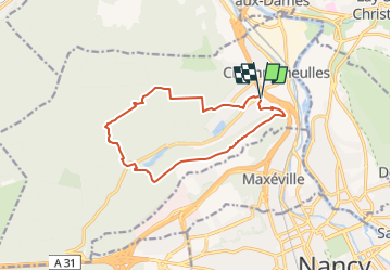
Tour Nordic Walking von 11,7 km verfügbar auf Großer Osten, Mörthe und Mosel, Champigneulles. Diese Tour wird von DanielROLLET vorgeschlagen.
Beschreibung
2021 04 29 Marche nordique Temps couvert et frais mais calme
8h50 à 11h50
Cueillette ail des ours dans le Vallon du Noirval (présence de muguet.
Ort
Land:
France
Region :
Großer Osten
Abteilung/Provinz :
Mörthe und Mosel
Kommune :
Champigneulles
Standort:
Unknown
Gehen Sie:(Dec)
Gehen Sie:(UTM)
291190 ; 5401204 (32U) N.
Kommentare
Touren in der Umgebung
![Tour Zu Fuß Champigneulles - Circuit G - Photo](https://media.geolcdn.com/t/375/260/367653e8-319c-4965-be92-65937a99215e.jpeg&format=jpg&maxdim=2)
![Zu Fuß Zu Fuß](https://static1.geolcdn.com/sitytour/trail-icons/100.png)
Circuit G
Zu Fuß
Medium
Champigneulles,
Großer Osten,
Mörthe und Mosel,
France
![](/images/other/stat-length.png)
18,7 km | 24 km-effort
5h 24min
![](https://static1.geolcdn.com/siteimages/upload/files/16400158638029165_repeat_loop_refresh_sync_direction_icon.png)
Nein
![Tour Zu Fuß Champigneulles - Circuit du Val Saint-Barthélémy - Photo](https://media.geolcdn.com/t/375/260/199ee8e6-f9b7-4be8-9188-093275697409.jpeg&format=jpg&maxdim=2)
![Zu Fuß Zu Fuß](https://static1.geolcdn.com/sitytour/trail-icons/100.png)
Circuit du Val Saint-Barthélémy
Zu Fuß
Einfach
Champigneulles,
Großer Osten,
Mörthe und Mosel,
France
![](/images/other/stat-length.png)
7 km | 8,6 km-effort
1h 57min
![](https://static1.geolcdn.com/siteimages/upload/files/16400158638029165_repeat_loop_refresh_sync_direction_icon.png)
Ja
![Tour Zu Fuß Champigneulles - Circuit du Noirval - Photo](https://media.geolcdn.com/t/375/260/199ee8e6-f9b7-4be8-9188-093275697409.jpeg&format=jpg&maxdim=2)
![Zu Fuß Zu Fuß](https://static1.geolcdn.com/sitytour/trail-icons/100.png)
Circuit du Noirval
Zu Fuß
Einfach
Champigneulles,
Großer Osten,
Mörthe und Mosel,
France
![](/images/other/stat-length.png)
11,1 km | 13,5 km-effort
3h 4min
![](https://static1.geolcdn.com/siteimages/upload/files/16400158638029165_repeat_loop_refresh_sync_direction_icon.png)
Ja
![Tour Wandern Nancy - Ma dernière avant opération - Photo](https://media.geolcdn.com/t/375/260/ext.jpg?maxdim=2&url=https%3A%2F%2Fstatic1.geolcdn.com%2Fsiteimages%2Fupload%2Ffiles%2F1553511878bg_sport_marche.png)
![Wandern Wandern](https://static1.geolcdn.com/sitytour/trail-icons/101.png)
Ma dernière avant opération
Wandern
Sehr schwierig
(1)
Nancy,
Großer Osten,
Mörthe und Mosel,
France
![](/images/other/stat-length.png)
22 km | 25 km-effort
4h 12min
![](https://static1.geolcdn.com/siteimages/upload/files/16400158638029165_repeat_loop_refresh_sync_direction_icon.png)
Ja
![Tour Radtourismus Frouard - 4ème rando vélo Frouard - Lagarde 62 km - Photo](https://media.geolcdn.com/t/375/260/13993c5f-3965-404c-880f-e186b1a79db8.jpg&format=jpg&maxdim=2)
![Radtourismus Radtourismus](https://static1.geolcdn.com/sitytour/trail-icons/204.png)
4ème rando vélo Frouard - Lagarde 62 km
Radtourismus
Sehr schwierig
Frouard,
Großer Osten,
Mörthe und Mosel,
France
![](/images/other/stat-length.png)
62 km | 67 km-effort
4h 32min
![](https://static1.geolcdn.com/siteimages/upload/files/16400158638029165_repeat_loop_refresh_sync_direction_icon.png)
Nein
![Tour Wandern Nancy - Ma rando du jour - Photo](https://media.geolcdn.com/t/375/260/c990ad83-2661-43f9-99e0-4498fd5d020a.jpg&format=jpg&maxdim=2)
![Wandern Wandern](https://static1.geolcdn.com/sitytour/trail-icons/101.png)
Ma rando du jour
Wandern
Schwierig
Nancy,
Großer Osten,
Mörthe und Mosel,
France
![](/images/other/stat-length.png)
35 km | 41 km-effort
5h 55min
![](https://static1.geolcdn.com/siteimages/upload/files/16400158638029165_repeat_loop_refresh_sync_direction_icon.png)
Ja
![Tour Wandern Nancy - Nancy Gondreville Nancy - Photo](https://media.geolcdn.com/t/375/260/171b4f53-1717-4b2e-9789-6c40dd8e1481.jpg&format=jpg&maxdim=2)
![Wandern Wandern](https://static1.geolcdn.com/sitytour/trail-icons/101.png)
Nancy Gondreville Nancy
Wandern
Schwierig
Nancy,
Großer Osten,
Mörthe und Mosel,
France
![](/images/other/stat-length.png)
64 km | 74 km-effort
10h 57min
![](https://static1.geolcdn.com/siteimages/upload/files/16400158638029165_repeat_loop_refresh_sync_direction_icon.png)
Ja
![Tour Wandern Nancy - Nancy Saizeray Jaillon Pierre la Treiche Marion Nancy - Photo](https://media.geolcdn.com/t/375/260/9e40712a-6db3-4fe8-9edd-58851d16cb4f.jpg&format=jpg&maxdim=2)
![Wandern Wandern](https://static1.geolcdn.com/sitytour/trail-icons/101.png)
Nancy Saizeray Jaillon Pierre la Treiche Marion Nancy
Wandern
Schwierig
Nancy,
Großer Osten,
Mörthe und Mosel,
France
![](/images/other/stat-length.png)
73 km | 85 km-effort
12h 13min
![](https://static1.geolcdn.com/siteimages/upload/files/16400158638029165_repeat_loop_refresh_sync_direction_icon.png)
Ja
![Tour Zu Fuß Lay-Saint-Christophe - Circuit L - Photo](https://media.geolcdn.com/t/375/260/8edc069d-a9b9-439a-9f46-3e2f5923a387.jpeg&format=jpg&maxdim=2)
![Zu Fuß Zu Fuß](https://static1.geolcdn.com/sitytour/trail-icons/100.png)
Circuit L
Zu Fuß
Einfach
Lay-Saint-Christophe,
Großer Osten,
Mörthe und Mosel,
France
![](/images/other/stat-length.png)
14,7 km | 18,5 km-effort
4h 11min
![](https://static1.geolcdn.com/siteimages/upload/files/16400158638029165_repeat_loop_refresh_sync_direction_icon.png)
Ja