![](/images/other/stat-length.png)
![Tour Laufen Zillig - Autour du trou du perou depuis saint leger - Photo](https://media.geolcdn.com/t/1900/400/ext.pjpeg?maxdim=2&url=https%3A%2F%2Fstatic1.geolcdn.com%2Fsiteimages%2Fupload%2Ffiles%2F1524743154running.jpg)
Autour du trou du perou depuis saint leger
iznogud
Benutzer
![Länge](/images/other/stat-length.png)
Länge
11,5 km
![Maximale Höhe](https://static1.geolcdn.com/siteimages/upload/files/1508320355ic_sort_altitude_max_24dp.png)
Maximale Höhe
366 m
![Positive Höhendifferenz](https://static1.geolcdn.com/siteimages/upload/files/1508320355ic_sort_den_pos_24dp.png)
Positive Höhendifferenz
163 m
![Km-Effort](/images/other/stat-length.png)
Km-Effort
13,7 km
![Min. Höhe](https://static1.geolcdn.com/siteimages/upload/files/1508320355ic_sort_altitude_min_24dp.png)
Min. Höhe
254 m
![Negative Höhendifferenz](https://static1.geolcdn.com/siteimages/upload/files/1508320355ic_sort_den_neg_24dp.png)
Negative Höhendifferenz
163 m
![Boucle](https://static1.geolcdn.com/siteimages/upload/files/16400158638029165_repeat_loop_refresh_sync_direction_icon.png)
Boucle
Ja
Erstellungsdatum :
2021-04-28 10:08:00.0
Letzte Änderung :
2021-04-28 15:11:45.08
![Laufen](https://static1.geolcdn.com/sitytour/trail-icons/103.png)
5h02
Schwierigkeit : Unbekannt
![Scannen Sie diesen QR-Code, um die Tour in der SityTrail-Anwendung zu öffnen](https://capi.geolives.com/qq0zvz2zws4bq2lad0pu/sitytour/trails/2765491/qr.png?size=200)
Kostenlosegpshiking-Anwendung
Über SityTrail
Tour Laufen von 11,5 km verfügbar auf Wallonien, Luxemburg, Zillig. Diese Tour wird von iznogud vorgeschlagen.
Beschreibung
Départ direction la déchèterie . Ensuite entrée dans le bois et remontée jusqu à la sablière . Retour en direction du fourneau David
Ort
Land:
Belgium
Region :
Wallonien
Abteilung/Provinz :
Luxemburg
Kommune :
Zillig
Standort:
Saint-Léger
Gehen Sie:(Dec)
Gehen Sie:(UTM)
691763 ; 5498769 (31U) N.
Kommentare
Touren in der Umgebung
![Tour Wandern Emsong - Willancourt - Natura 2000, des sites qui valent le détour - Lx13 - Photo](https://media.geolcdn.com/t/375/260/ext.jpg?maxdim=2&url=https%3A%2F%2Fservices.sitytrail.com%2FGeolivesWS%2FDownloadMedia.ashx%3FTrailID%3D181441%26Media%3D78228147-13f6-4f8a-9ed5-33e8c071dddd.jpg)
![Wandern Wandern](https://static1.geolcdn.com/sitytour/trail-icons/101.png)
Willancourt - Natura 2000, des sites qui valent le détour - Lx13
Wandern
Einfach
(4)
Emsong,
Wallonien,
Luxemburg,
Belgium
![](/images/other/stat-length.png)
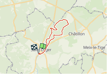
7,6 km | 9,8 km-effort
2h 7min
![](https://static1.geolcdn.com/siteimages/upload/files/16400158638029165_repeat_loop_refresh_sync_direction_icon.png)
Ja
![Tour Mountainbike Emsong - Willancourt Chapelle du Bonlieu Site de Montauban Eperons barre - Photo](https://media.geolcdn.com/t/375/260/ext.jpg?maxdim=2&url=https%3A%2F%2Fservices.sitytrail.com%2FGeolivesWS%2FDownloadMedia.ashx%3FTrailID%3D848004%26Media%3Dfix__20171018173409.jpg)
![Mountainbike Mountainbike](https://static1.geolcdn.com/sitytour/trail-icons/202.png)
Willancourt Chapelle du Bonlieu Site de Montauban Eperons barre
Mountainbike
Schwierig
(1)
Emsong,
Wallonien,
Luxemburg,
Belgium
![](/images/other/stat-length.png)
38 km | 48 km-effort
2h 44min
![](https://static1.geolcdn.com/siteimages/upload/files/16400158638029165_repeat_loop_refresh_sync_direction_icon.png)
Ja
![Tour Wandern Wirten - GAUME Balade naturelle et historique - Photo](https://media.geolcdn.com/t/375/260/ext.jpg?maxdim=2&url=https%3A%2F%2Fservices.sitytrail.com%2FGeolivesWS%2FDownloadMedia.ashx%3FTrailID%3D164521%26Media%3D20121125163840.jpeg)
![Wandern Wandern](https://static1.geolcdn.com/sitytour/trail-icons/101.png)
GAUME Balade naturelle et historique
Wandern
Sehr leicht
(1)
Wirten,
Wallonien,
Luxemburg,
Belgium
![](/images/other/stat-length.png)
5,2 km | 6,8 km-effort
1h 16min
![](https://static1.geolcdn.com/siteimages/upload/files/16400158638029165_repeat_loop_refresh_sync_direction_icon.png)
Ja
![Tour Wandern Zillig - RF-Lu-14 - Au pays des lavoirs anciens et des usoirs : Châtillon - Photo](https://media.geolcdn.com/t/375/260/ext.jpg?maxdim=2&url=https%3A%2F%2Fservices.sitytrail.com%2FGeolivesWS%2FDownloadMedia.ashx%3FTrailID%3D407136%26Media%3D623ce8e1-010c-490a-9987-548abb1b02b7.jpg)
![Wandern Wandern](https://static1.geolcdn.com/sitytour/trail-icons/101.png)
RF-Lu-14 - Au pays des lavoirs anciens et des usoirs : Châtillon
Wandern
Sehr leicht
(1)
Zillig,
Wallonien,
Luxemburg,
Belgium
![](/images/other/stat-length.png)
12,6 km | 16,2 km-effort
3h 29min
![](https://static1.geolcdn.com/siteimages/upload/files/16400158638029165_repeat_loop_refresh_sync_direction_icon.png)
Ja
![Tour Zu Fuß Emsong - Promenade dans le village fleuri - Photo](https://media.geolcdn.com/t/375/260/ext.jpg?maxdim=2&url=https%3A%2F%2Fpivotmedia.tourismewallonie.be%2FOTH-A0-006F-0EIN%2FOTH-A0-006F-0EIN.jpg)
![Zu Fuß Zu Fuß](https://static1.geolcdn.com/sitytour/trail-icons/100.png)
Promenade dans le village fleuri
Zu Fuß
Einfach
Emsong,
Wallonien,
Luxemburg,
Belgium
![](/images/other/stat-length.png)
3,7 km | 4,7 km-effort
1h 4min
![](https://static1.geolcdn.com/siteimages/upload/files/16400158638029165_repeat_loop_refresh_sync_direction_icon.png)
Ja
![Tour Wandern Wirten - Buzenol - Circuit Natura 2000, des sites qui valent le détour - Lx17 - Photo](https://media.geolcdn.com/t/375/260/ext.jpg?maxdim=2&url=https%3A%2F%2Fservices.sitytrail.com%2FGeolivesWS%2FDownloadMedia.ashx%3FTrailID%3D434845%26Media%3Dffe101bc-fd35-4310-a917-20a586f102b3.JPG)
![Wandern Wandern](https://static1.geolcdn.com/sitytour/trail-icons/101.png)
Buzenol - Circuit Natura 2000, des sites qui valent le détour - Lx17
Wandern
Medium
(1)
Wirten,
Wallonien,
Luxemburg,
Belgium
![](/images/other/stat-length.png)
13,5 km | 16,7 km-effort
2h 0min
![](https://static1.geolcdn.com/siteimages/upload/files/16400158638029165_repeat_loop_refresh_sync_direction_icon.png)
Ja
![Tour Wandern Étalle - GAUME Boucle vers la vallee de la Rougeau - Photo](https://media.geolcdn.com/t/375/260/ext.jpg?maxdim=2&url=https%3A%2F%2Fstatic1.geolcdn.com%2Fsiteimages%2Fupload%2Ffiles%2F1553511878bg_sport_marche.png)
![Wandern Wandern](https://static1.geolcdn.com/sitytour/trail-icons/101.png)
GAUME Boucle vers la vallee de la Rougeau
Wandern
Einfach
(3)
Étalle,
Wallonien,
Luxemburg,
Belgium
![](/images/other/stat-length.png)
5,6 km | 7,1 km-effort
1h 32min
![](https://static1.geolcdn.com/siteimages/upload/files/16400158638029165_repeat_loop_refresh_sync_direction_icon.png)
Ja
![Tour Wandern Zillig - GAUME Balade dans les dunes de chatillon - Photo](https://media.geolcdn.com/t/375/260/ext.jpg?maxdim=2&url=https%3A%2F%2Fstatic1.geolcdn.com%2Fsiteimages%2Fupload%2Ffiles%2F1553511878bg_sport_marche.png)
![Wandern Wandern](https://static1.geolcdn.com/sitytour/trail-icons/101.png)
GAUME Balade dans les dunes de chatillon
Wandern
Sehr leicht
(1)
Zillig,
Wallonien,
Luxemburg,
Belgium
![](/images/other/stat-length.png)
3,6 km | 4,4 km-effort
58min
![](https://static1.geolcdn.com/siteimages/upload/files/16400158638029165_repeat_loop_refresh_sync_direction_icon.png)
Ja
![Tour Wandern Étalle - Chantemelle la tranchée des portes - Photo](https://media.geolcdn.com/t/375/260/61188bc8-d295-4809-ba0b-7ca5757e1f85.jpg&format=jpg&maxdim=2)
![Wandern Wandern](https://static1.geolcdn.com/sitytour/trail-icons/101.png)
Chantemelle la tranchée des portes
Wandern
Einfach
Étalle,
Wallonien,
Luxemburg,
Belgium
![](/images/other/stat-length.png)
10,8 km | 12,6 km-effort
2h 30min
![](https://static1.geolcdn.com/siteimages/upload/files/16400158638029165_repeat_loop_refresh_sync_direction_icon.png)
Ja