![](/images/other/stat-length.png)
Promenade au Bois des Waibes à Thuin
Desrumaux
Benutzer GUIDE
![Länge](/images/other/stat-length.png)
Länge
8,9 km
![Maximale Höhe](https://static1.geolcdn.com/siteimages/upload/files/1508320355ic_sort_altitude_max_24dp.png)
Maximale Höhe
205 m
![Positive Höhendifferenz](https://static1.geolcdn.com/siteimages/upload/files/1508320355ic_sort_den_pos_24dp.png)
Positive Höhendifferenz
188 m
![Km-Effort](/images/other/stat-length.png)
Km-Effort
11,4 km
![Min. Höhe](https://static1.geolcdn.com/siteimages/upload/files/1508320355ic_sort_altitude_min_24dp.png)
Min. Höhe
112 m
![Negative Höhendifferenz](https://static1.geolcdn.com/siteimages/upload/files/1508320355ic_sort_den_neg_24dp.png)
Negative Höhendifferenz
188 m
![Boucle](https://static1.geolcdn.com/siteimages/upload/files/16400158638029165_repeat_loop_refresh_sync_direction_icon.png)
Boucle
Ja
Erstellungsdatum :
2021-04-26 15:56:02.936
Letzte Änderung :
2021-04-26 17:25:48.882
![Wandern](https://static1.geolcdn.com/sitytour/trail-icons/101.png)
2h35
Schwierigkeit : Medium
![Scannen Sie diesen QR-Code, um die Tour in der SityTrail-Anwendung zu öffnen](https://capi.geolives.com/qq0zvz2zws4bq2lad0pu/sitytour/trails/2763393/qr.png?size=200)
Kostenlosegpshiking-Anwendung
Über SityTrail
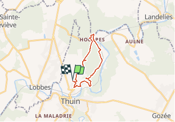
Tour Wandern von 8,9 km verfügbar auf Wallonien, Hennegau, Thuin. Diese Tour wird von Desrumaux vorgeschlagen.
Beschreibung
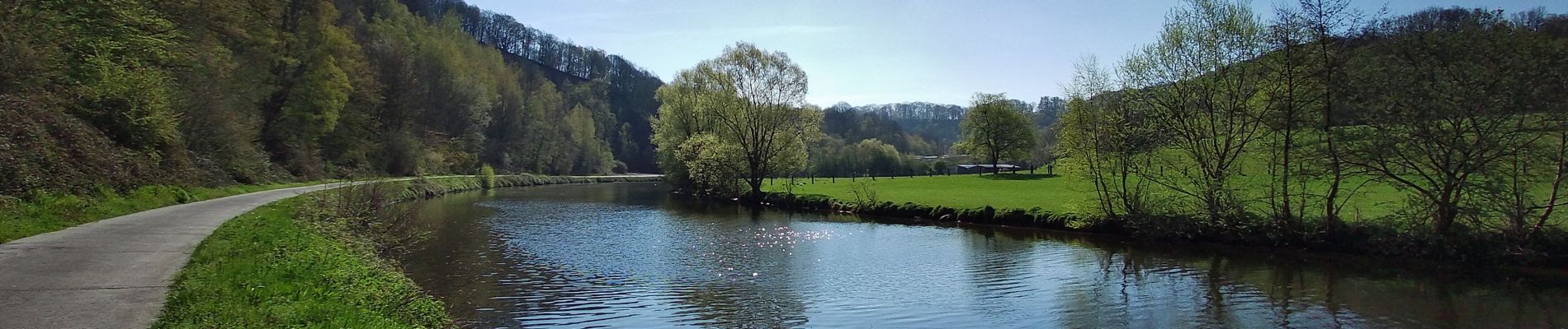
Jolie balade dans le Val de Sambre bien connu des Thudinien au départ des Waibes vers le hameau de Hourpes dans la belle entité de Thuin.
Ort
Land:
Belgium
Region :
Wallonien
Abteilung/Provinz :
Hennegau
Kommune :
Thuin
Standort:
Thuin
Gehen Sie:(Dec)
Gehen Sie:(UTM)
591713 ; 5578222 (31U) N.
Kommentare
Touren in der Umgebung
![Tour Wandern Fontaine-l'Évêque - de l'Abbaye d'Aulne au hameau de Hourpes - Thuin - Photo](https://media.geolcdn.com/t/375/260/a34a09f7-2ebf-4334-b3ab-6307c79b316f.jpeg&format=jpg&maxdim=2)
![Wandern Wandern](https://static1.geolcdn.com/sitytour/trail-icons/101.png)
de l'Abbaye d'Aulne au hameau de Hourpes - Thuin
Wandern
Sehr leicht
(2)
Fontaine-l'Évêque,
Wallonien,
Hennegau,
Belgium
![](/images/other/stat-length.png)
8,7 km | 10,9 km-effort
3h 16min
![](https://static1.geolcdn.com/siteimages/upload/files/16400158638029165_repeat_loop_refresh_sync_direction_icon.png)
Ja
![Tour Wandern Thuin - La balade du Bois des Waibes. - Photo](https://media.geolcdn.com/t/375/260/ext.jpg?maxdim=2&url=https%3A%2F%2Fservices.sitytrail.com%2FGeolivesWS%2FDownloadMedia.ashx%3FTrailID%3D846785%26Media%3D2a15c231-0cbe-4107-9b4e-b0ca15c25a1f.jpg)
![Wandern Wandern](https://static1.geolcdn.com/sitytour/trail-icons/101.png)
La balade du Bois des Waibes.
Wandern
Einfach
(4)
Thuin,
Wallonien,
Hennegau,
Belgium
![](/images/other/stat-length.png)
9,9 km | 12 km-effort
2h 41min
![](https://static1.geolcdn.com/siteimages/upload/files/16400158638029165_repeat_loop_refresh_sync_direction_icon.png)
Ja
![Tour Wandern Montigny-le-Tilleul - Balade en Val de Sambre - De Landelies à l'Abbaye d'Aulne - Photo](https://media.geolcdn.com/t/375/260/ext.jpg?maxdim=2&url=https%3A%2F%2Fservices.sitytrail.com%2FGeolivesWS%2FDownloadMedia.ashx%3FTrailID%3D498562%26Media%3D0c817a37-45f6-4c22-ab94-a572de965186.JPG)
![Wandern Wandern](https://static1.geolcdn.com/sitytour/trail-icons/101.png)
Balade en Val de Sambre - De Landelies à l'Abbaye d'Aulne
Wandern
Sehr leicht
(1)
Montigny-le-Tilleul,
Wallonien,
Hennegau,
Belgium
![](/images/other/stat-length.png)
6,6 km | 8 km-effort
1h 49min
![](https://static1.geolcdn.com/siteimages/upload/files/16400158638029165_repeat_loop_refresh_sync_direction_icon.png)
Ja
![Wandern Wandern](https://static1.geolcdn.com/sitytour/trail-icons/101.png)
BE-Montigny-le-Tilleul - Landelies - Aulne - 2
Wandern
Sehr leicht
(1)
Montigny-le-Tilleul,
Wallonien,
Hennegau,
Belgium
![](/images/other/stat-length.png)
7,1 km | 9,6 km-effort
2h 4min
![](https://static1.geolcdn.com/siteimages/upload/files/16400158638029165_repeat_loop_refresh_sync_direction_icon.png)
Ja
![Tour Wandern Lobbes - Balade à Mont-Sainte-Geneviève - Photo](https://media.geolcdn.com/t/375/260/ext.jpg?maxdim=2&url=https%3A%2F%2Fservices.sitytrail.com%2FGeolivesWS%2FDownloadMedia.ashx%3FTrailID%3D378767%26Media%3D9ad7b20e-c031-407f-875d-742351009cf4.jpg)
![Wandern Wandern](https://static1.geolcdn.com/sitytour/trail-icons/101.png)
Balade à Mont-Sainte-Geneviève
Wandern
Sehr leicht
(3)
Lobbes,
Wallonien,
Hennegau,
Belgium
![](/images/other/stat-length.png)
9,1 km | 10,4 km-effort
2h 18min
![](https://static1.geolcdn.com/siteimages/upload/files/16400158638029165_repeat_loop_refresh_sync_direction_icon.png)
Ja
![Tour Wandern Thuin - RB-Ha-08 – Raccourci 1 - Tours et détours entre Beaumont et Barbençon - Photo](https://media.geolcdn.com/t/375/260/ext.jpg?maxdim=2&url=https%3A%2F%2Fservices.sitytrail.com%2FGeolivesWS%2FDownloadMedia.ashx%3FTrailID%3D218762%26Media%3D7e0b1de5-2210-4f38-aa84-2fca8ae33ab8.jpg)
![Wandern Wandern](https://static1.geolcdn.com/sitytour/trail-icons/101.png)
RB-Ha-08 – Raccourci 1 - Tours et détours entre Beaumont et Barbençon
Wandern
Sehr schwierig
(2)
Thuin,
Wallonien,
Hennegau,
Belgium
![](/images/other/stat-length.png)
25 km | 32 km-effort
7h 12min
![](https://static1.geolcdn.com/siteimages/upload/files/16400158638029165_repeat_loop_refresh_sync_direction_icon.png)
Ja
![Tour Wandern Thuin - RB-Ha-08 - Tours et détours entre Beaumont et Barbençon - Photo](https://media.geolcdn.com/t/375/260/ext.jpg?maxdim=2&url=https%3A%2F%2Fservices.sitytrail.com%2FGeolivesWS%2FDownloadMedia.ashx%3FTrailID%3D179601%26Media%3D33d5cfdf-1096-4ca0-9209-00c5bbfd32f4.jpg)
![Wandern Wandern](https://static1.geolcdn.com/sitytour/trail-icons/101.png)
RB-Ha-08 - Tours et détours entre Beaumont et Barbençon
Wandern
Sehr schwierig
(2)
Thuin,
Wallonien,
Hennegau,
Belgium
![](/images/other/stat-length.png)
22 km | 28 km-effort
6h 26min
![](https://static1.geolcdn.com/siteimages/upload/files/16400158638029165_repeat_loop_refresh_sync_direction_icon.png)
Ja
![Tour Wandern Thuin - Thuin - De la Ville Haute à la Ville Basse - Photo](https://media.geolcdn.com/t/375/260/ext.jpg?maxdim=2&url=https%3A%2F%2Fservices.sitytrail.com%2FGeolivesWS%2FDownloadMedia.ashx%3FTrailID%3D96827%26Media%3Da38cc2d0-85a8-4251-9b00-ce6dea30fa93.JPG)
![Wandern Wandern](https://static1.geolcdn.com/sitytour/trail-icons/101.png)
Thuin - De la Ville Haute à la Ville Basse
Wandern
Einfach
(4)
Thuin,
Wallonien,
Hennegau,
Belgium
![](/images/other/stat-length.png)
4,5 km | 6,6 km-effort
1h 20min
![](https://static1.geolcdn.com/siteimages/upload/files/16400158638029165_repeat_loop_refresh_sync_direction_icon.png)
Ja
![Tour Wandern Lobbes - LOBBES (vers Hourpes) dép RHS - Photo](https://media.geolcdn.com/t/375/260/d9a7042e-0c53-41c5-a007-94b83a09ecc3.jpg&format=jpg&maxdim=2)
![Wandern Wandern](https://static1.geolcdn.com/sitytour/trail-icons/101.png)
LOBBES (vers Hourpes) dép RHS
Wandern
Medium
(1)
Lobbes,
Wallonien,
Hennegau,
Belgium
![](/images/other/stat-length.png)
7,2 km | 8,6 km-effort
2h 1min
![](https://static1.geolcdn.com/siteimages/upload/files/16400158638029165_repeat_loop_refresh_sync_direction_icon.png)
Ja