![](/images/other/stat-length.png)
![Tour Wandern Valdeblore - Lacs du Baus du Castel en raquettes - Photo](https://media.geolcdn.com/t/1900/400/ext.pjpeg?maxdim=2&url=https%3A%2F%2Fstatic1.geolcdn.com%2Fsiteimages%2Fupload%2Ffiles%2F1553511878bg_sport_marche.png)
Lacs du Baus du Castel en raquettes
aris
Benutzer
![Länge](/images/other/stat-length.png)
Länge
10,6 km
![Maximale Höhe](https://static1.geolcdn.com/siteimages/upload/files/1508320355ic_sort_altitude_max_24dp.png)
Maximale Höhe
2263 m
![Positive Höhendifferenz](https://static1.geolcdn.com/siteimages/upload/files/1508320355ic_sort_den_pos_24dp.png)
Positive Höhendifferenz
717 m
![Km-Effort](/images/other/stat-length.png)
Km-Effort
20 km
![Min. Höhe](https://static1.geolcdn.com/siteimages/upload/files/1508320355ic_sort_altitude_min_24dp.png)
Min. Höhe
1645 m
![Negative Höhendifferenz](https://static1.geolcdn.com/siteimages/upload/files/1508320355ic_sort_den_neg_24dp.png)
Negative Höhendifferenz
713 m
![Boucle](https://static1.geolcdn.com/siteimages/upload/files/16400158638029165_repeat_loop_refresh_sync_direction_icon.png)
Boucle
Ja
Erstellungsdatum :
2021-04-25 07:03:05.111
Letzte Änderung :
2021-04-25 15:39:54.466
![Wandern](https://static1.geolcdn.com/sitytour/trail-icons/101.png)
5h27
Schwierigkeit : Medium
![Scannen Sie diesen QR-Code, um die Tour in der SityTrail-Anwendung zu öffnen](https://capi.geolives.com/qq0zvz2zws4bq2lad0pu/sitytour/trails/2761770/qr.png?size=200)
Kostenlosegpshiking-Anwendung
Über SityTrail
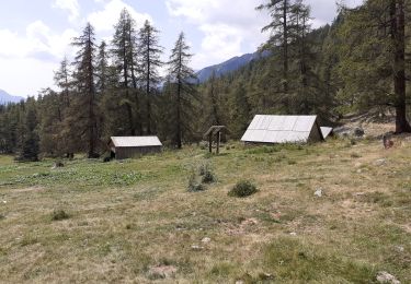
Tour Wandern von 10,6 km verfügbar auf Provence-Alpes-Côte d'Azur, Seealpen, Valdeblore. Diese Tour wird von aris vorgeschlagen.
Beschreibung
Un peu de neige dans la montée du vallon Anduébis, montée hors sentier raide dans la végétation. Chaussé les raquettes au niveau du 1er petit lac.
Ort
Land:
France
Region :
Provence-Alpes-Côte d'Azur
Abteilung/Provinz :
Seealpen
Kommune :
Valdeblore
Standort:
Unknown
Gehen Sie:(Dec)
Gehen Sie:(UTM)
358429 ; 4881941 (32T) N.
Kommentare
Touren in der Umgebung
![Tour Wandern Valdeblore - pepoiri - Photo](https://media.geolcdn.com/t/375/260/8ca18259-e53b-4625-8dc3-3afb9e53eb6b.jpg&format=jpg&maxdim=2)
![Wandern Wandern](https://static1.geolcdn.com/sitytour/trail-icons/101.png)
pepoiri
Wandern
Sehr leicht
(1)
Valdeblore,
Provence-Alpes-Côte d'Azur,
Seealpen,
France
![](/images/other/stat-length.png)
7,8 km | 16,3 km-effort
5h 31min
![](https://static1.geolcdn.com/siteimages/upload/files/16400158638029165_repeat_loop_refresh_sync_direction_icon.png)
Ja
![Tour Wandern Venanson - La Malouna - Photo](https://media.geolcdn.com/t/375/260/ext.jpg?maxdim=2&url=https%3A%2F%2Fservices.sitytrail.com%2FGeolivesWS%2FDownloadMedia.ashx%3FTrailID%3D405887%26Media%3Dfix__20150409152656.jpg)
![Wandern Wandern](https://static1.geolcdn.com/sitytour/trail-icons/101.png)
La Malouna
Wandern
Medium
(1)
Venanson,
Provence-Alpes-Côte d'Azur,
Seealpen,
France
![](/images/other/stat-length.png)
10,7 km | 17,9 km-effort
5h 20min
![](https://static1.geolcdn.com/siteimages/upload/files/16400158638029165_repeat_loop_refresh_sync_direction_icon.png)
Ja
![Tour Zu Fuß Valdeblore - Le Caïre Gros - Photo](https://media.geolcdn.com/t/375/260/3c6df4dd-1089-48da-8830-4c0973863251.jpeg&format=jpg&maxdim=2)
![Zu Fuß Zu Fuß](https://static1.geolcdn.com/sitytour/trail-icons/100.png)
Le Caïre Gros
Zu Fuß
Medium
Valdeblore,
Provence-Alpes-Côte d'Azur,
Seealpen,
France
![](/images/other/stat-length.png)
9,8 km | 20 km-effort
4h 38min
![](https://static1.geolcdn.com/siteimages/upload/files/16400158638029165_repeat_loop_refresh_sync_direction_icon.png)
Ja
![Tour Zu Fuß Saint-Martin-Vésubie - Col de Cerise - Photo](https://media.geolcdn.com/t/375/260/90b1ce11-d155-4ca1-8f15-a1d1ec21efc7.jpeg&format=jpg&maxdim=2)
![Zu Fuß Zu Fuß](https://static1.geolcdn.com/sitytour/trail-icons/100.png)
Col de Cerise
Zu Fuß
Medium
Saint-Martin-Vésubie,
Provence-Alpes-Côte d'Azur,
Seealpen,
France
![](/images/other/stat-length.png)
9,7 km | 23 km-effort
5h 18min
![](https://static1.geolcdn.com/siteimages/upload/files/16400158638029165_repeat_loop_refresh_sync_direction_icon.png)
Ja
![Tour Zu Fuß Venanson - Circuit du Conquet - Photo](https://media.geolcdn.com/t/375/260/e58595d6-e9ca-4e12-a313-f11c5e4c7d45.jpeg&format=jpg&maxdim=2)
![Zu Fuß Zu Fuß](https://static1.geolcdn.com/sitytour/trail-icons/100.png)
Circuit du Conquet
Zu Fuß
Medium
Venanson,
Provence-Alpes-Côte d'Azur,
Seealpen,
France
![](/images/other/stat-length.png)
10,2 km | 21 km-effort
4h 45min
![](https://static1.geolcdn.com/siteimages/upload/files/16400158638029165_repeat_loop_refresh_sync_direction_icon.png)
Ja
![Wandern Wandern](https://static1.geolcdn.com/sitytour/trail-icons/101.png)
Lac de Trécolpas - Pas des Ladres - refuge de Cougourde
Wandern
Sehr schwierig
Saint-Martin-Vésubie,
Provence-Alpes-Côte d'Azur,
Seealpen,
France
![](/images/other/stat-length.png)
17 km | 30 km-effort
5h 45min
![](https://static1.geolcdn.com/siteimages/upload/files/16400158638029165_repeat_loop_refresh_sync_direction_icon.png)
Ja
![Tour Wandern Valdeblore - Les Lacs des Millefonts (Variante) - Photo](https://media.geolcdn.com/t/375/260/9ec3a33c-746a-4f95-a3bf-1bc95c27318a.jpg&format=jpg&maxdim=2)
![Wandern Wandern](https://static1.geolcdn.com/sitytour/trail-icons/101.png)
Les Lacs des Millefonts (Variante)
Wandern
Schwierig
Valdeblore,
Provence-Alpes-Côte d'Azur,
Seealpen,
France
![](/images/other/stat-length.png)
10,1 km | 19,4 km-effort
4h 5min
![](https://static1.geolcdn.com/siteimages/upload/files/16400158638029165_repeat_loop_refresh_sync_direction_icon.png)
Ja
![Tour Wandern Saint-Martin-Vésubie - Tour de la Vallée du Boréon - Photo](https://media.geolcdn.com/t/375/260/c27c6217-906b-4fb0-92a6-1ad8d294a181.jpg&format=jpg&maxdim=2)
![Wandern Wandern](https://static1.geolcdn.com/sitytour/trail-icons/101.png)
Tour de la Vallée du Boréon
Wandern
Schwierig
Saint-Martin-Vésubie,
Provence-Alpes-Côte d'Azur,
Seealpen,
France
![](/images/other/stat-length.png)
15,2 km | 26 km-effort
4h 45min
![](https://static1.geolcdn.com/siteimages/upload/files/16400158638029165_repeat_loop_refresh_sync_direction_icon.png)
Ja
![Tour Skiwanderen Valdeblore - Pèpoiri et Petoumier - Photo](https://media.geolcdn.com/t/375/260/b5f7f954-f6d6-45d0-b44a-3f93e1cb0060.jpg&format=jpg&maxdim=2)
![Skiwanderen Skiwanderen](https://static1.geolcdn.com/sitytour/trail-icons/503.png)
Pèpoiri et Petoumier
Skiwanderen
Medium
Valdeblore,
Provence-Alpes-Côte d'Azur,
Seealpen,
France
![](/images/other/stat-length.png)
12,8 km | 31 km-effort
6h 44min
![](https://static1.geolcdn.com/siteimages/upload/files/16400158638029165_repeat_loop_refresh_sync_direction_icon.png)
Ja