![](/images/other/stat-length.png)
![Tour Wandern Idron - IDRON- Tour du Golf Golf-Centre équestre-EPHAD - RS - Photo](https://media.geolcdn.com/t/1900/400/ext.pjpeg?maxdim=2&url=https%3A%2F%2Fstatic1.geolcdn.com%2Fsiteimages%2Fupload%2Ffiles%2F1553511878bg_sport_marche.png)
IDRON- Tour du Golf Golf-Centre équestre-EPHAD - RS
mitch1952
Benutzer
![Länge](/images/other/stat-length.png)
Länge
4,4 km
![Maximale Höhe](https://static1.geolcdn.com/siteimages/upload/files/1508320355ic_sort_altitude_max_24dp.png)
Maximale Höhe
250 m
![Positive Höhendifferenz](https://static1.geolcdn.com/siteimages/upload/files/1508320355ic_sort_den_pos_24dp.png)
Positive Höhendifferenz
30 m
![Km-Effort](/images/other/stat-length.png)
Km-Effort
4,8 km
![Min. Höhe](https://static1.geolcdn.com/siteimages/upload/files/1508320355ic_sort_altitude_min_24dp.png)
Min. Höhe
241 m
![Negative Höhendifferenz](https://static1.geolcdn.com/siteimages/upload/files/1508320355ic_sort_den_neg_24dp.png)
Negative Höhendifferenz
28 m
![Boucle](https://static1.geolcdn.com/siteimages/upload/files/16400158638029165_repeat_loop_refresh_sync_direction_icon.png)
Boucle
Ja
Erstellungsdatum :
2021-04-21 14:03:00.716
Letzte Änderung :
2022-06-08 13:16:25.256
![Wandern](https://static1.geolcdn.com/sitytour/trail-icons/101.png)
2h00
Schwierigkeit : Medium
![Scannen Sie diesen QR-Code, um die Tour in der SityTrail-Anwendung zu öffnen](https://capi.geolives.com/qq0zvz2zws4bq2lad0pu/sitytour/trails/2756412/qr.png?size=200)
Kostenlosegpshiking-Anwendung
Über SityTrail
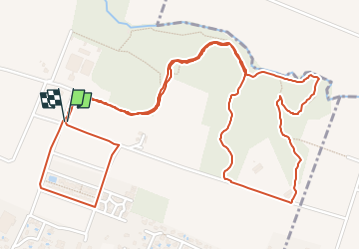
Tour Wandern von 4,4 km verfügbar auf Neu-Aquitanien, Pyrenäen-Atlantik, Idron. Diese Tour wird von mitch1952 vorgeschlagen.
Beschreibung
Passage près du laboratoire FAREVA (Fabrication du vaccin COVID 19), Vue sur le golf, Le Centre Equestre, le Parcours de santé et pour terminer l'EPAHD.
Ort
Land:
France
Region :
Neu-Aquitanien
Abteilung/Provinz :
Pyrenäen-Atlantik
Kommune :
Idron
Standort:
Unknown
Gehen Sie:(Dec)
Gehen Sie:(UTM)
719225 ; 4798201 (30T) N.
Kommentare
Touren in der Umgebung
![Tour Wandern Rontignon - Coteaux de Rontignon - Photo](https://media.geolcdn.com/t/375/260/ext.jpg?maxdim=2&url=https%3A%2F%2Fservices.sitytrail.com%2FGeolivesWS%2FDownloadMedia.ashx%3FTrailID%3D103073%26Media%3D4763_4.jpg)
![Wandern Wandern](https://static1.geolcdn.com/sitytour/trail-icons/101.png)
Coteaux de Rontignon
Wandern
Medium
(3)
Rontignon,
Neu-Aquitanien,
Pyrenäen-Atlantik,
France
![](/images/other/stat-length.png)
7,3 km | 10,1 km-effort
1h 45min
![](https://static1.geolcdn.com/siteimages/upload/files/16400158638029165_repeat_loop_refresh_sync_direction_icon.png)
Ja
![Tour Wandern Idron - Idron golf - Photo](https://media.geolcdn.com/t/375/260/ext.jpg?maxdim=2&url=https%3A%2F%2Fstatic1.geolcdn.com%2Fsiteimages%2Fupload%2Ffiles%2F1553511878bg_sport_marche.png)
![Wandern Wandern](https://static1.geolcdn.com/sitytour/trail-icons/101.png)
Idron golf
Wandern
Sehr leicht
(1)
Idron,
Neu-Aquitanien,
Pyrenäen-Atlantik,
France
![](/images/other/stat-length.png)
3,3 km | 3,6 km-effort
48min
![](https://static1.geolcdn.com/siteimages/upload/files/16400158638029165_repeat_loop_refresh_sync_direction_icon.png)
Ja
![Tour Wandern Pau - PAU RS entre jardins et villa quartier Trespoey](https://media.geolcdn.com/t/375/260/4ef921b3-2e64-48c5-a483-91dfaca18d96.jpg&format=jpg&maxdim=2)
![Wandern Wandern](https://static1.geolcdn.com/sitytour/trail-icons/101.png)
PAU RS entre jardins et villa quartier Trespoey "3644386"
Wandern
Medium
Pau,
Neu-Aquitanien,
Pyrenäen-Atlantik,
France
![](/images/other/stat-length.png)
5,5 km | 6,2 km-effort
1h 24min
![](https://static1.geolcdn.com/siteimages/upload/files/16400158638029165_repeat_loop_refresh_sync_direction_icon.png)
Ja
![Tour Wandern Assat - BALISAGE GR 782 OUSSE / PONT DU14 JUILLET le 4/04/2023](https://media.geolcdn.com/t/375/260/eb1c9c16-be7e-4360-bd65-bc0bfd1108bb.jpg&format=jpg&maxdim=2)
![Wandern Wandern](https://static1.geolcdn.com/sitytour/trail-icons/101.png)
BALISAGE GR 782 OUSSE / PONT DU14 JUILLET le 4/04/2023 "3608855"
Wandern
Schwierig
Assat,
Neu-Aquitanien,
Pyrenäen-Atlantik,
France
![](/images/other/stat-length.png)
11,3 km | 12,9 km-effort
2h 56min
![](https://static1.geolcdn.com/siteimages/upload/files/16400158638029165_repeat_loop_refresh_sync_direction_icon.png)
Nein
![Tour Wandern Bizanos - BIZANOS RANDONNÉE PATRIMOINE 2868740 - Photo](https://media.geolcdn.com/t/375/260/213837b0-04be-4f10-8a02-95ffa46e349c.jpg&format=jpg&maxdim=2)
![Wandern Wandern](https://static1.geolcdn.com/sitytour/trail-icons/101.png)
BIZANOS RANDONNÉE PATRIMOINE 2868740
Wandern
Einfach
Bizanos,
Neu-Aquitanien,
Pyrenäen-Atlantik,
France
![](/images/other/stat-length.png)
7,6 km | 8,6 km-effort
1h 52min
![](https://static1.geolcdn.com/siteimages/upload/files/16400158638029165_repeat_loop_refresh_sync_direction_icon.png)
Nein
![Tour Wandern Assat - OUSSE a la rencontre de Cesar M2 - Photo](https://media.geolcdn.com/t/375/260/be0f19de-b432-4b6e-a08d-e17178e1c230.jpg&format=jpg&maxdim=2)
![Wandern Wandern](https://static1.geolcdn.com/sitytour/trail-icons/101.png)
OUSSE a la rencontre de Cesar M2
Wandern
Einfach
Assat,
Neu-Aquitanien,
Pyrenäen-Atlantik,
France
![](/images/other/stat-length.png)
8,3 km | 10,2 km-effort
2h 5min
![](https://static1.geolcdn.com/siteimages/upload/files/16400158638029165_repeat_loop_refresh_sync_direction_icon.png)
Ja
![Tour Wandern Rontignon - RONTIGNON le chemin des crêtes M2 fait 2644181 - Photo](https://media.geolcdn.com/t/375/260/797f6c13-d1f6-445b-af12-f454d456b125.jpg&format=jpg&maxdim=2)
![Wandern Wandern](https://static1.geolcdn.com/sitytour/trail-icons/101.png)
RONTIGNON le chemin des crêtes M2 fait 2644181
Wandern
Einfach
Rontignon,
Neu-Aquitanien,
Pyrenäen-Atlantik,
France
![](/images/other/stat-length.png)
8,5 km | 12 km-effort
2h 5min
![](https://static1.geolcdn.com/siteimages/upload/files/16400158638029165_repeat_loop_refresh_sync_direction_icon.png)
Ja
![Tour Wandern Uzos - UZOS la boucle de la glandee balisee le 29 07 20 - Photo](https://media.geolcdn.com/t/375/260/e45bec67-f808-4c2a-b223-22164fa7db06.jpg&format=jpg&maxdim=2)
![Wandern Wandern](https://static1.geolcdn.com/sitytour/trail-icons/101.png)
UZOS la boucle de la glandee balisee le 29 07 20
Wandern
Medium
Uzos,
Neu-Aquitanien,
Pyrenäen-Atlantik,
France
![](/images/other/stat-length.png)
13,1 km | 17,3 km-effort
8h 14min
![](https://static1.geolcdn.com/siteimages/upload/files/16400158638029165_repeat_loop_refresh_sync_direction_icon.png)
Ja
![Tour Wandern Idron - IDRON Deconfinement seul - Photo](https://media.geolcdn.com/t/375/260/c0185c73-9332-4a95-b3e0-d63027a94adb.jpg&format=jpg&maxdim=2)
![Wandern Wandern](https://static1.geolcdn.com/sitytour/trail-icons/101.png)
IDRON Deconfinement seul
Wandern
Medium
Idron,
Neu-Aquitanien,
Pyrenäen-Atlantik,
France
![](/images/other/stat-length.png)
9,6 km | 11,1 km-effort
2h 8min
![](https://static1.geolcdn.com/siteimages/upload/files/16400158638029165_repeat_loop_refresh_sync_direction_icon.png)
Ja