![](/images/other/stat-length.png)
![Tour Zu Fuß Baelen - Hautes-Fagnes par les bivouacs, jour 2 - Photo](https://media.geolcdn.com/t/1900/400/ext.pjpeg?maxdim=2&url=https%3A%2F%2Fstatic1.geolcdn.com%2Fsiteimages%2Fupload%2Ffiles%2F1545311037marcheuse_200dpi.jpg)
Hautes-Fagnes par les bivouacs, jour 2
MathieuBourgois
Benutzer
![Länge](/images/other/stat-length.png)
Länge
29 km
![Maximale Höhe](https://static1.geolcdn.com/siteimages/upload/files/1508320355ic_sort_altitude_max_24dp.png)
Maximale Höhe
485 m
![Positive Höhendifferenz](https://static1.geolcdn.com/siteimages/upload/files/1508320355ic_sort_den_pos_24dp.png)
Positive Höhendifferenz
616 m
![Km-Effort](/images/other/stat-length.png)
Km-Effort
36 km
![Min. Höhe](https://static1.geolcdn.com/siteimages/upload/files/1508320355ic_sort_altitude_min_24dp.png)
Min. Höhe
293 m
![Negative Höhendifferenz](https://static1.geolcdn.com/siteimages/upload/files/1508320355ic_sort_den_neg_24dp.png)
Negative Höhendifferenz
456 m
![Boucle](https://static1.geolcdn.com/siteimages/upload/files/16400158638029165_repeat_loop_refresh_sync_direction_icon.png)
Boucle
Nein
Erstellungsdatum :
2021-04-20 11:42:13.722
Letzte Änderung :
2021-04-20 11:44:11.439
![Zu Fuß](https://static1.geolcdn.com/sitytour/trail-icons/100.png)
8h15
Schwierigkeit : Schwierig
![Scannen Sie diesen QR-Code, um die Tour in der SityTrail-Anwendung zu öffnen](https://capi.geolives.com/qq0zvz2zws4bq2lad0pu/sitytour/trails/2754914/qr.png?size=200)
Kostenlosegpshiking-Anwendung
Über SityTrail
Tour Zu Fuß von 29 km verfügbar auf Wallonien, Lüttich, Baelen. Diese Tour wird von MathieuBourgois vorgeschlagen.
Beschreibung
Du Bivouac dde la Gileppe au Bivouac de la Bergerie
28km et 600D
Ravitaillement à Jalhay en début de matinée
Resto-bar au barrage de la Gileppe
Ort
Land:
Belgium
Region :
Wallonien
Abteilung/Provinz :
Lüttich
Kommune :
Baelen
Standort:
Membach
Gehen Sie:(Dec)
Gehen Sie:(UTM)
287928 ; 5606661 (32U) N.
Kommentare
Touren in der Umgebung
![Tour Wandern Limburg - RB-Lg-28_Limbourg - Photo](https://media.geolcdn.com/t/375/260/ext.jpg?maxdim=2&url=https%3A%2F%2Fservices.sitytrail.com%2FGeolivesWS%2FDownloadMedia.ashx%3FTrailID%3D402093%26Media%3D979895a6-f139-4f7a-8335-2e926c1b89c7.jpg)
![Wandern Wandern](https://static1.geolcdn.com/sitytour/trail-icons/101.png)
RB-Lg-28_Limbourg
Wandern
(5)
Limburg,
Wallonien,
Lüttich,
Belgium
![](/images/other/stat-length.png)
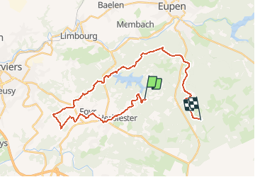
19,9 km | 26 km-effort
5h 49min
![](https://static1.geolcdn.com/siteimages/upload/files/16400158638029165_repeat_loop_refresh_sync_direction_icon.png)
Ja
![Tour Wandern Jalhay - La Gileppe - Bois de la Borchêne - Photo](https://media.geolcdn.com/t/375/260/e6c1c191-9060-48ef-8a65-d77cc5b69a34.jpg&format=jpg&maxdim=2)
![Wandern Wandern](https://static1.geolcdn.com/sitytour/trail-icons/101.png)
La Gileppe - Bois de la Borchêne
Wandern
Einfach
(3)
Jalhay,
Wallonien,
Lüttich,
Belgium
![](/images/other/stat-length.png)
7,6 km | 9,8 km-effort
2h 13min
![](https://static1.geolcdn.com/siteimages/upload/files/16400158638029165_repeat_loop_refresh_sync_direction_icon.png)
Ja
![Tour Wandern Jalhay - 2021-11-16_21h27m43_Cirkwi-Balade_à_Jalhay-Royompré_-_47 - Photo](https://media.geolcdn.com/t/375/260/94c262e0-20e7-4ae2-8b45-01b4c31da73b.jpg&format=jpg&maxdim=2)
![Wandern Wandern](https://static1.geolcdn.com/sitytour/trail-icons/101.png)
2021-11-16_21h27m43_Cirkwi-Balade_à_Jalhay-Royompré_-_47
Wandern
Einfach
(2)
Jalhay,
Wallonien,
Lüttich,
Belgium
![](/images/other/stat-length.png)
11 km | 13,9 km-effort
3h 9min
![](https://static1.geolcdn.com/siteimages/upload/files/16400158638029165_repeat_loop_refresh_sync_direction_icon.png)
Ja
![Tour Wandern Baelen - La Montagne du Dragon - Photo](https://media.geolcdn.com/t/375/260/3a1bc634-7bf5-4748-bbb3-513b265a48b5.jpg&format=jpg&maxdim=2)
![Wandern Wandern](https://static1.geolcdn.com/sitytour/trail-icons/101.png)
La Montagne du Dragon
Wandern
Einfach
(1)
Baelen,
Wallonien,
Lüttich,
Belgium
![](/images/other/stat-length.png)
16,2 km | 21 km-effort
3h 21min
![](https://static1.geolcdn.com/siteimages/upload/files/16400158638029165_repeat_loop_refresh_sync_direction_icon.png)
Ja
![Wandern Wandern](https://static1.geolcdn.com/sitytour/trail-icons/101.png)
20210205 - La Gileppe 7.3 Km
Wandern
Medium
(1)
Jalhay,
Wallonien,
Lüttich,
Belgium
![](/images/other/stat-length.png)
7,6 km | 9,9 km-effort
2h 24min
![](https://static1.geolcdn.com/siteimages/upload/files/16400158638029165_repeat_loop_refresh_sync_direction_icon.png)
Ja
![Tour Wandern Limburg - 20200606 - Hèvremont 8 Km - Photo](https://media.geolcdn.com/t/375/260/8311f513-ce09-455a-b0ac-51a7423b07df.jpg&format=jpg&maxdim=2)
![Wandern Wandern](https://static1.geolcdn.com/sitytour/trail-icons/101.png)
20200606 - Hèvremont 8 Km
Wandern
Schwierig
(1)
Limburg,
Wallonien,
Lüttich,
Belgium
![](/images/other/stat-length.png)
7,9 km | 10,7 km-effort
1h 34min
![](https://static1.geolcdn.com/siteimages/upload/files/16400158638029165_repeat_loop_refresh_sync_direction_icon.png)
Ja
![Tour Wandern Baelen - Hestreux - Circuit Natura 2000 - Lg 23 - Photo](https://media.geolcdn.com/t/375/260/ext.jpg?maxdim=2&url=https%3A%2F%2Fservices.sitytrail.com%2FGeolivesWS%2FDownloadMedia.ashx%3FTrailID%3D543693%26Media%3Db6dc624c-a5db-4eb7-8557-25b4defb2280.JPG)
![Wandern Wandern](https://static1.geolcdn.com/sitytour/trail-icons/101.png)
Hestreux - Circuit Natura 2000 - Lg 23
Wandern
Einfach
(4)
Baelen,
Wallonien,
Lüttich,
Belgium
![](/images/other/stat-length.png)
8,6 km | 10,3 km-effort
3h 0min
![](https://static1.geolcdn.com/siteimages/upload/files/16400158638029165_repeat_loop_refresh_sync_direction_icon.png)
Nein
![Tour Wandern Jalhay - La Gileppe - Photo](https://media.geolcdn.com/t/375/260/9374fc26-a93b-4b0a-b10a-5ceb74ed5a19.jpg&format=jpg&maxdim=2)
![Wandern Wandern](https://static1.geolcdn.com/sitytour/trail-icons/101.png)
La Gileppe
Wandern
Einfach
(1)
Jalhay,
Wallonien,
Lüttich,
Belgium
![](/images/other/stat-length.png)
14,1 km | 18 km-effort
4h 6min
![](https://static1.geolcdn.com/siteimages/upload/files/16400158638029165_repeat_loop_refresh_sync_direction_icon.png)
Ja
![Tour Wandern Jalhay - Chemin des Sources | Etappe Nr. 6 JALHAY - LA GILEPPE - JEHANSTER - Photo](https://media.geolcdn.com/t/375/260/a7a4ff23-971f-4e96-9104-7d3f8188981b.jpg&format=jpg&maxdim=2)
![Wandern Wandern](https://static1.geolcdn.com/sitytour/trail-icons/101.png)
Chemin des Sources | Etappe Nr. 6 JALHAY - LA GILEPPE - JEHANSTER
Wandern
Schwierig
(2)
Jalhay,
Wallonien,
Lüttich,
Belgium
![](/images/other/stat-length.png)
14,3 km | 17,4 km-effort
3h 56min
![](https://static1.geolcdn.com/siteimages/upload/files/16400158638029165_repeat_loop_refresh_sync_direction_icon.png)
Nein