![](/images/other/stat-length.png)
Le grès rouge
houbart
Benutzer
![Länge](/images/other/stat-length.png)
Länge
4,3 km
![Maximale Höhe](https://static1.geolcdn.com/siteimages/upload/files/1508320355ic_sort_altitude_max_24dp.png)
Maximale Höhe
217 m
![Positive Höhendifferenz](https://static1.geolcdn.com/siteimages/upload/files/1508320355ic_sort_den_pos_24dp.png)
Positive Höhendifferenz
110 m
![Km-Effort](/images/other/stat-length.png)
Km-Effort
5,8 km
![Min. Höhe](https://static1.geolcdn.com/siteimages/upload/files/1508320355ic_sort_altitude_min_24dp.png)
Min. Höhe
119 m
![Negative Höhendifferenz](https://static1.geolcdn.com/siteimages/upload/files/1508320355ic_sort_den_neg_24dp.png)
Negative Höhendifferenz
110 m
![Boucle](https://static1.geolcdn.com/siteimages/upload/files/16400158638029165_repeat_loop_refresh_sync_direction_icon.png)
Boucle
Ja
Erstellungsdatum :
2019-03-28 15:47:39.527
Letzte Änderung :
2019-03-28 15:47:39.589
![Wandern](https://static1.geolcdn.com/sitytour/trail-icons/101.png)
1h14
Schwierigkeit : Einfach
![Scannen Sie diesen QR-Code, um die Tour in der SityTrail-Anwendung zu öffnen](https://capi.geolives.com/qq0zvz2zws4bq2lad0pu/sitytour/trails/275332/qr.png?size=200)
Kostenlosegpshiking-Anwendung
Über SityTrail
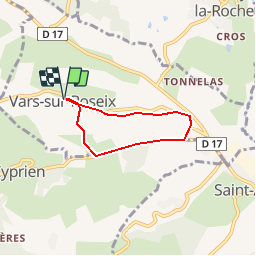
Tour Wandern von 4,3 km verfügbar auf Neu-Aquitanien, Corrèze, Vars-sur-Roseix. Diese Tour wird von houbart vorgeschlagen.
Beschreibung
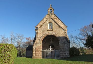
Départ place de l'église à Vars sur Roseix. Eglise des XIIe et XIVe. Belles maisons en brasier.
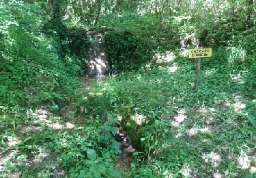
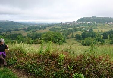
Facile mais grimpette un peu dure sur la fin du trajet.
Ort
Land:
France
Region :
Neu-Aquitanien
Abteilung/Provinz :
Corrèze
Kommune :
Vars-sur-Roseix
Standort:
Unknown
Gehen Sie:(Dec)
Gehen Sie:(UTM)
371618 ; 5013082 (31T) N.
Kommentare
Touren in der Umgebung
![Tour Wandern Ayen - Ayen-160621 - CoteauxAyenSud - Photo](https://media.geolcdn.com/t/375/260/ext.jpg?maxdim=2&url=https%3A%2F%2Fservices.sitytrail.com%2FGeolivesWS%2FDownloadMedia.ashx%3FTrailID%3D587734%26Media%3Dfix__20160621100049.jpg)
![Wandern Wandern](https://static1.geolcdn.com/sitytour/trail-icons/101.png)
Ayen-160621 - CoteauxAyenSud
Wandern
Einfach
(1)
Ayen,
Neu-Aquitanien,
Corrèze,
France
![](/images/other/stat-length.png)
6,4 km | 8,8 km-effort
1h 50min
![](https://static1.geolcdn.com/siteimages/upload/files/16400158638029165_repeat_loop_refresh_sync_direction_icon.png)
Nein
![Tour Wandern Ayen - Ayen - Photo](https://media.geolcdn.com/t/375/260/ext.jpg?maxdim=2&url=https%3A%2F%2Fstatic1.geolcdn.com%2Fsiteimages%2Fupload%2Ffiles%2F1553511878bg_sport_marche.png)
![Wandern Wandern](https://static1.geolcdn.com/sitytour/trail-icons/101.png)
![Tour Wandern Voutezac - Ayen-160623 - Ceyrat-FontaineCrozes - Photo](https://media.geolcdn.com/t/375/260/ext.jpg?maxdim=2&url=https%3A%2F%2Fservices.sitytrail.com%2FGeolivesWS%2FDownloadMedia.ashx%3FTrailID%3D588114%26Media%3Dfix__20160623115501.jpg)
![Wandern Wandern](https://static1.geolcdn.com/sitytour/trail-icons/101.png)
Ayen-160623 - Ceyrat-FontaineCrozes
Wandern
Medium
Voutezac,
Neu-Aquitanien,
Corrèze,
France
![](/images/other/stat-length.png)
7,5 km | 10,7 km-effort
2h 35min
![](https://static1.geolcdn.com/siteimages/upload/files/16400158638029165_repeat_loop_refresh_sync_direction_icon.png)
Ja
![Tour Wandern Ayen - Ayen-160622 - Ayen-SaintCyprien - Photo](https://media.geolcdn.com/t/375/260/ext.jpg?maxdim=2&url=https%3A%2F%2Fservices.sitytrail.com%2FGeolivesWS%2FDownloadMedia.ashx%3FTrailID%3D587739%26Media%3Dfix__20160622105342.jpg)
![Wandern Wandern](https://static1.geolcdn.com/sitytour/trail-icons/101.png)
Ayen-160622 - Ayen-SaintCyprien
Wandern
Einfach
Ayen,
Neu-Aquitanien,
Corrèze,
France
![](/images/other/stat-length.png)
9,3 km | 12,9 km-effort
2h 40min
![](https://static1.geolcdn.com/siteimages/upload/files/16400158638029165_repeat_loop_refresh_sync_direction_icon.png)
Nein
![Tour Wandern Perpezac-le-Blanc - perpezac_3 - Photo](https://media.geolcdn.com/t/375/260/ext.jpg?maxdim=2&url=https%3A%2F%2Fstatic1.geolcdn.com%2Fsiteimages%2Fupload%2Ffiles%2F1553511878bg_sport_marche.png)
![Wandern Wandern](https://static1.geolcdn.com/sitytour/trail-icons/101.png)
perpezac_3
Wandern
Medium
(1)
Perpezac-le-Blanc,
Neu-Aquitanien,
Corrèze,
France
![](/images/other/stat-length.png)
7,4 km | 10,3 km-effort
2h 13min
![](https://static1.geolcdn.com/siteimages/upload/files/16400158638029165_repeat_loop_refresh_sync_direction_icon.png)
Ja
![Tour Wandern Saint-Cyprien - Ruisseaux et côteaux- Saint-Cyprien - Photo](https://media.geolcdn.com/t/375/260/ext.jpg?maxdim=2&url=https%3A%2F%2Fstatic1.geolcdn.com%2Fsiteimages%2Fupload%2Ffiles%2F1553511878bg_sport_marche.png)
![Wandern Wandern](https://static1.geolcdn.com/sitytour/trail-icons/101.png)
Ruisseaux et côteaux- Saint-Cyprien
Wandern
Einfach
(3)
Saint-Cyprien,
Neu-Aquitanien,
Corrèze,
France
![](/images/other/stat-length.png)
6,4 km | 9,1 km-effort
1h 59min
![](https://static1.geolcdn.com/siteimages/upload/files/16400158638029165_repeat_loop_refresh_sync_direction_icon.png)
Ja
![Tour Wandern Ayen - Ayen, lavoirs, châteaux et puys - Photo](https://media.geolcdn.com/t/375/260/ext.jpg?maxdim=2&url=https%3A%2F%2Fservices.sitytrail.com%2FGeolivesWS%2FDownloadMedia.ashx%3FTrailID%3D329157%26Media%3D552f9bfa-df09-44d9-92ec-820d3a3190ab.JPG)
![Wandern Wandern](https://static1.geolcdn.com/sitytour/trail-icons/101.png)
Ayen, lavoirs, châteaux et puys
Wandern
Einfach
Ayen,
Neu-Aquitanien,
Corrèze,
France
![](/images/other/stat-length.png)
5,5 km | 7,6 km-effort
2h 0min
![](https://static1.geolcdn.com/siteimages/upload/files/16400158638029165_repeat_loop_refresh_sync_direction_icon.png)
Ja
![Tour Wandern Objat - Objat-St Cyr la Roche - Photo](https://media.geolcdn.com/t/375/260/ext.jpg?maxdim=2&url=https%3A%2F%2Fservices.sitytrail.com%2FGeolivesWS%2FDownloadMedia.ashx%3FTrailID%3D666310%26Media%3D23b63755-09da-4d45-b084-38737c07ffb3.JPG)
![Wandern Wandern](https://static1.geolcdn.com/sitytour/trail-icons/101.png)
Objat-St Cyr la Roche
Wandern
Einfach
Objat,
Neu-Aquitanien,
Corrèze,
France
![](/images/other/stat-length.png)
8 km | 10,5 km-effort
2h 12min
![](https://static1.geolcdn.com/siteimages/upload/files/16400158638029165_repeat_loop_refresh_sync_direction_icon.png)
Ja
![Tour Wandern Ayen - Ayen-160620 - CoteauxAyenNord - Photo](https://media.geolcdn.com/t/375/260/ext.jpg?maxdim=2&url=https%3A%2F%2Fservices.sitytrail.com%2FGeolivesWS%2FDownloadMedia.ashx%3FTrailID%3D587725%26Media%3Dfix__20160620101558.jpg)
![Wandern Wandern](https://static1.geolcdn.com/sitytour/trail-icons/101.png)
Ayen-160620 - CoteauxAyenNord
Wandern
Einfach
Ayen,
Neu-Aquitanien,
Corrèze,
France
![](/images/other/stat-length.png)
6,4 km | 8,5 km-effort
2h 0min
![](https://static1.geolcdn.com/siteimages/upload/files/16400158638029165_repeat_loop_refresh_sync_direction_icon.png)
Nein