![](/images/other/stat-length.png)
![Tour Wandern Château-l'Évêque - Boucle du bois de Lavergne - Photo](https://media.geolcdn.com/t/1900/400/6537e41d-5ba3-471f-b695-a5c123990690.jpg&format=pjpeg&maxdim=2)
Boucle du bois de Lavergne
CC.RIDER
Benutzer
![Länge](/images/other/stat-length.png)
Länge
14,1 km
![Maximale Höhe](https://static1.geolcdn.com/siteimages/upload/files/1508320355ic_sort_altitude_max_24dp.png)
Maximale Höhe
228 m
![Positive Höhendifferenz](https://static1.geolcdn.com/siteimages/upload/files/1508320355ic_sort_den_pos_24dp.png)
Positive Höhendifferenz
276 m
![Km-Effort](/images/other/stat-length.png)
Km-Effort
17,8 km
![Min. Höhe](https://static1.geolcdn.com/siteimages/upload/files/1508320355ic_sort_altitude_min_24dp.png)
Min. Höhe
101 m
![Negative Höhendifferenz](https://static1.geolcdn.com/siteimages/upload/files/1508320355ic_sort_den_neg_24dp.png)
Negative Höhendifferenz
276 m
![Boucle](https://static1.geolcdn.com/siteimages/upload/files/16400158638029165_repeat_loop_refresh_sync_direction_icon.png)
Boucle
Ja
Erstellungsdatum :
2021-04-15 18:08:12.112
Letzte Änderung :
2021-04-15 18:12:33.737
![Wandern](https://static1.geolcdn.com/sitytour/trail-icons/101.png)
4h02
Schwierigkeit : Schwierig
![Scannen Sie diesen QR-Code, um die Tour in der SityTrail-Anwendung zu öffnen](https://capi.geolives.com/qq0zvz2zws4bq2lad0pu/sitytour/trails/2748756/qr.png?size=200)
Kostenlosegpshiking-Anwendung
Über SityTrail
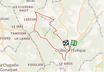
Tour Wandern von 14,1 km verfügbar auf Neu-Aquitanien, Dordogne, Château-l'Évêque. Diese Tour wird von CC.RIDER vorgeschlagen.
Beschreibung
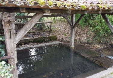
Au départ de Château l'Evêque, une rando par monts et par vaux avec le joli vallon et les étangs de la fontaine de Laguizat.
Ort
Land:
France
Region :
Neu-Aquitanien
Abteilung/Provinz :
Dordogne
Kommune :
Château-l'Évêque
Standort:
Unknown
Gehen Sie:(Dec)
Gehen Sie:(UTM)
318384 ; 5012898 (31T) N.
Kommentare
Touren in der Umgebung
![Tour Wandern Champcevinel - champcevinel - Photo](https://media.geolcdn.com/t/375/260/ee6533d5-1951-437a-84ea-112f8c5e298d.jpg&format=jpg&maxdim=2)
![Wandern Wandern](https://static1.geolcdn.com/sitytour/trail-icons/101.png)
champcevinel
Wandern
Schwierig
Champcevinel,
Neu-Aquitanien,
Dordogne,
France
![](/images/other/stat-length.png)
9,7 km | 12,3 km-effort
2h 48min
![](https://static1.geolcdn.com/siteimages/upload/files/16400158638029165_repeat_loop_refresh_sync_direction_icon.png)
Ja
![Tour Wandern Château-l'Évêque - Preyssac - Photo](https://media.geolcdn.com/t/375/260/88e8b94c-04c3-4391-bcaf-c73b6b33a5ce.jpg&format=jpg&maxdim=2)
![Wandern Wandern](https://static1.geolcdn.com/sitytour/trail-icons/101.png)
Preyssac
Wandern
Schwierig
Château-l'Évêque,
Neu-Aquitanien,
Dordogne,
France
![](/images/other/stat-length.png)
11 km | 14,5 km-effort
3h 17min
![](https://static1.geolcdn.com/siteimages/upload/files/16400158638029165_repeat_loop_refresh_sync_direction_icon.png)
Ja
![Tour Wandern Chancelade - Circuit de l'Abbaye de Chancelade - Photo](https://media.geolcdn.com/t/375/260/16bcd257-155c-4b42-a479-9684c98ab4d4.jpg&format=jpg&maxdim=2)
![Wandern Wandern](https://static1.geolcdn.com/sitytour/trail-icons/101.png)
Circuit de l'Abbaye de Chancelade
Wandern
Schwierig
Chancelade,
Neu-Aquitanien,
Dordogne,
France
![](/images/other/stat-length.png)
12,8 km | 18,3 km-effort
4h 9min
![](https://static1.geolcdn.com/siteimages/upload/files/16400158638029165_repeat_loop_refresh_sync_direction_icon.png)
Ja
![Tour Wandern Chancelade - Boucle des Andrivaux - Photo](https://media.geolcdn.com/t/375/260/3a7f865a-dc4d-41a4-a258-9294003c8232.jpg&format=jpg&maxdim=2)
![Wandern Wandern](https://static1.geolcdn.com/sitytour/trail-icons/101.png)
Boucle des Andrivaux
Wandern
Sehr schwierig
Chancelade,
Neu-Aquitanien,
Dordogne,
France
![](/images/other/stat-length.png)
14,8 km | 19,3 km-effort
4h 23min
![](https://static1.geolcdn.com/siteimages/upload/files/16400158638029165_repeat_loop_refresh_sync_direction_icon.png)
Ja
![Tour Wandern Chancelade - Boucle de la Terrassonnie - Photo](https://media.geolcdn.com/t/375/260/ext.jpg?maxdim=2&url=https%3A%2F%2Fservices.sitytrail.com%2FGeolivesWS%2FDownloadMedia.ashx%3FTrailID%3D1093073%26Media%3Dfix__20190106115620.jpg)
![Wandern Wandern](https://static1.geolcdn.com/sitytour/trail-icons/101.png)
Boucle de la Terrassonnie
Wandern
Einfach
Chancelade,
Neu-Aquitanien,
Dordogne,
France
![](/images/other/stat-length.png)
11,2 km | 14,7 km-effort
3h 37min
![](https://static1.geolcdn.com/siteimages/upload/files/16400158638029165_repeat_loop_refresh_sync_direction_icon.png)
Ja
![Tour Wandern Château-l'Évêque - CHATEAU-LEVEQUE - Boucle de Preyssac courte - Photo](https://media.geolcdn.com/t/375/260/ext.jpg?maxdim=2&url=https%3A%2F%2Fstatic1.geolcdn.com%2Fsiteimages%2Fupload%2Ffiles%2F1553511878bg_sport_marche.png)
![Wandern Wandern](https://static1.geolcdn.com/sitytour/trail-icons/101.png)
CHATEAU-LEVEQUE - Boucle de Preyssac courte
Wandern
Schwierig
Château-l'Évêque,
Neu-Aquitanien,
Dordogne,
France
![](/images/other/stat-length.png)
11,3 km | 15,4 km-effort
3h 29min
![](https://static1.geolcdn.com/siteimages/upload/files/16400158638029165_repeat_loop_refresh_sync_direction_icon.png)
Ja
![Tour Wandern Château-l'Évêque - boucle Chateau l'Eveque - Photo](https://media.geolcdn.com/t/375/260/ext.jpg?maxdim=2&url=https%3A%2F%2Fstatic1.geolcdn.com%2Fsiteimages%2Fupload%2Ffiles%2F1553511878bg_sport_marche.png)
![Wandern Wandern](https://static1.geolcdn.com/sitytour/trail-icons/101.png)
boucle Chateau l'Eveque
Wandern
Medium
Château-l'Évêque,
Neu-Aquitanien,
Dordogne,
France
![](/images/other/stat-length.png)
13,7 km | 18,3 km-effort
3h 28min
![](https://static1.geolcdn.com/siteimages/upload/files/16400158638029165_repeat_loop_refresh_sync_direction_icon.png)
Ja
![Tour Wandern Champcevinel - Boucle Champcevinel par lac Lacroix - Photo](https://media.geolcdn.com/t/375/260/ext.jpg?maxdim=2&url=https%3A%2F%2Fstatic1.geolcdn.com%2Fsiteimages%2Fupload%2Ffiles%2F1553511878bg_sport_marche.png)
![Wandern Wandern](https://static1.geolcdn.com/sitytour/trail-icons/101.png)
Boucle Champcevinel par lac Lacroix
Wandern
Einfach
Champcevinel,
Neu-Aquitanien,
Dordogne,
France
![](/images/other/stat-length.png)
12,1 km | 15,4 km-effort
2h 45min
![](https://static1.geolcdn.com/siteimages/upload/files/16400158638029165_repeat_loop_refresh_sync_direction_icon.png)
Ja
![Tour Wandern Chancelade - Chancelade - Photo](https://media.geolcdn.com/t/375/260/f516afca-a53a-45cf-8602-c47268c2e555.jpg&format=jpg&maxdim=2)
![Wandern Wandern](https://static1.geolcdn.com/sitytour/trail-icons/101.png)
Chancelade
Wandern
Schwierig
Chancelade,
Neu-Aquitanien,
Dordogne,
France
![](/images/other/stat-length.png)
13,7 km | 18,4 km-effort
4h 11min
![](https://static1.geolcdn.com/siteimages/upload/files/16400158638029165_repeat_loop_refresh_sync_direction_icon.png)
Ja