![](/images/other/stat-length.png)
![Tour Wandern Savignac-les-Églises - Boucle du Camp de la Hache - Photo](https://media.geolcdn.com/t/1900/400/7bc93c96-c45e-4e69-becc-481f54185a15.jpg&format=pjpeg&maxdim=2)
Boucle du Camp de la Hache
CC.RIDER
Benutzer
![Länge](/images/other/stat-length.png)
Länge
13,4 km
![Maximale Höhe](https://static1.geolcdn.com/siteimages/upload/files/1508320355ic_sort_altitude_max_24dp.png)
Maximale Höhe
210 m
![Positive Höhendifferenz](https://static1.geolcdn.com/siteimages/upload/files/1508320355ic_sort_den_pos_24dp.png)
Positive Höhendifferenz
204 m
![Km-Effort](/images/other/stat-length.png)
Km-Effort
16,1 km
![Min. Höhe](https://static1.geolcdn.com/siteimages/upload/files/1508320355ic_sort_altitude_min_24dp.png)
Min. Höhe
107 m
![Negative Höhendifferenz](https://static1.geolcdn.com/siteimages/upload/files/1508320355ic_sort_den_neg_24dp.png)
Negative Höhendifferenz
201 m
![Boucle](https://static1.geolcdn.com/siteimages/upload/files/16400158638029165_repeat_loop_refresh_sync_direction_icon.png)
Boucle
Ja
Erstellungsdatum :
2021-04-13 22:54:58.799
Letzte Änderung :
2021-04-13 22:59:40.09
![Wandern](https://static1.geolcdn.com/sitytour/trail-icons/101.png)
3h39
Schwierigkeit : Schwierig
![Scannen Sie diesen QR-Code, um die Tour in der SityTrail-Anwendung zu öffnen](https://capi.geolives.com/qq0zvz2zws4bq2lad0pu/sitytour/trails/2746408/qr.png?size=200)
Kostenlosegpshiking-Anwendung
Über SityTrail
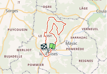
Tour Wandern von 13,4 km verfügbar auf Neu-Aquitanien, Dordogne, Savignac-les-Églises. Diese Tour wird von CC.RIDER vorgeschlagen.
Beschreibung
Au départ de Savignac les églises, monter au Causse, ancien terrain militaire maintenant parfaitement aménagé pour la randonnée, la marche nordique ou le VTT…
Ort
Land:
France
Region :
Neu-Aquitanien
Abteilung/Provinz :
Dordogne
Kommune :
Savignac-les-Églises
Standort:
Unknown
Gehen Sie:(Dec)
Gehen Sie:(UTM)
336425 ; 5015375 (31T) N.
Kommentare
Touren in der Umgebung
![Tour Wandern Sorges et Ligueux en Périgord - Sorges Causses et sous bois 10 km - Photo](https://media.geolcdn.com/t/375/260/ext.jpg?maxdim=2&url=https%3A%2F%2Fstatic1.geolcdn.com%2Fsiteimages%2Fupload%2Ffiles%2F1553511878bg_sport_marche.png)
![Wandern Wandern](https://static1.geolcdn.com/sitytour/trail-icons/101.png)
Sorges Causses et sous bois 10 km
Wandern
Einfach
(1)
Sorges et Ligueux en Périgord,
Neu-Aquitanien,
Dordogne,
France
![](/images/other/stat-length.png)
9,9 km | 12,6 km-effort
1h 49min
![](https://static1.geolcdn.com/siteimages/upload/files/16400158638029165_repeat_loop_refresh_sync_direction_icon.png)
Ja
![Tour Wandern Sorges et Ligueux en Périgord - Sorges Téléthon 2013 11km - Photo](https://media.geolcdn.com/t/375/260/ext.jpg?maxdim=2&url=https%3A%2F%2Fstatic1.geolcdn.com%2Fsiteimages%2Fupload%2Ffiles%2F1553511878bg_sport_marche.png)
![Wandern Wandern](https://static1.geolcdn.com/sitytour/trail-icons/101.png)
Sorges Téléthon 2013 11km
Wandern
Einfach
(1)
Sorges et Ligueux en Périgord,
Neu-Aquitanien,
Dordogne,
France
![](/images/other/stat-length.png)
11 km | 13,2 km-effort
2h 57min
![](https://static1.geolcdn.com/siteimages/upload/files/16400158638029165_repeat_loop_refresh_sync_direction_icon.png)
Ja
![Tour Wandern Sorges et Ligueux en Périgord - De Sorges à Perigueux sur la voie de Compostelle - Photo](https://media.geolcdn.com/t/375/260/4aaf4236-90c5-474d-8de9-7f6175f80c96.jpeg&format=jpg&maxdim=2)
![Wandern Wandern](https://static1.geolcdn.com/sitytour/trail-icons/101.png)
De Sorges à Perigueux sur la voie de Compostelle
Wandern
Sehr schwierig
Sorges et Ligueux en Périgord,
Neu-Aquitanien,
Dordogne,
France
![](/images/other/stat-length.png)
25 km | 31 km-effort
5h 26min
![](https://static1.geolcdn.com/siteimages/upload/files/16400158638029165_repeat_loop_refresh_sync_direction_icon.png)
Nein
![Tour Wandern Savignac-les-Églises - Causse de Savignac Artistique étendu 8km - Photo](https://media.geolcdn.com/t/375/260/ext.jpg?maxdim=2&url=https%3A%2F%2Fservices.sitytrail.com%2FGeolivesWS%2FDownloadMedia.ashx%3FTrailID%3D258421%26Media%3Dfix__20140318104035.jpg)
![Wandern Wandern](https://static1.geolcdn.com/sitytour/trail-icons/101.png)
Causse de Savignac Artistique étendu 8km
Wandern
Einfach
Savignac-les-Églises,
Neu-Aquitanien,
Dordogne,
France
![](/images/other/stat-length.png)
8,3 km | 10 km-effort
2h 18min
![](https://static1.geolcdn.com/siteimages/upload/files/16400158638029165_repeat_loop_refresh_sync_direction_icon.png)
Ja
![Tour Nordic Walking Saint-Vincent-sur-l'Isle - Saint Vincent sur l'Isle MN - Photo](https://media.geolcdn.com/t/375/260/e2b39c52-2522-47fc-9680-cd801e16f5c3.jpg&format=jpg&maxdim=2)
![Nordic Walking Nordic Walking](https://static1.geolcdn.com/sitytour/trail-icons/102.png)
Saint Vincent sur l'Isle MN
Nordic Walking
Medium
Saint-Vincent-sur-l'Isle,
Neu-Aquitanien,
Dordogne,
France
![](/images/other/stat-length.png)
10,3 km | 12,6 km-effort
Unbekannt
![](https://static1.geolcdn.com/siteimages/upload/files/16400158638029165_repeat_loop_refresh_sync_direction_icon.png)
Ja
![Tour Wandern Sorges et Ligueux en Périgord - Boucle des châteaux - Photo](https://media.geolcdn.com/t/375/260/ba5fb264-42c9-43e2-90fa-f6bdc036a39c.jpg&format=jpg&maxdim=2)
![Wandern Wandern](https://static1.geolcdn.com/sitytour/trail-icons/101.png)
Boucle des châteaux
Wandern
Schwierig
Sorges et Ligueux en Périgord,
Neu-Aquitanien,
Dordogne,
France
![](/images/other/stat-length.png)
14,4 km | 17,2 km-effort
3h 54min
![](https://static1.geolcdn.com/siteimages/upload/files/16400158638029165_repeat_loop_refresh_sync_direction_icon.png)
Ja
![Tour Wandern Mayac - Mayac - Photo](https://media.geolcdn.com/t/375/260/12dd5d1c-8883-4d4e-906f-957f8a8d0ac4.jpg&format=jpg&maxdim=2)
![Wandern Wandern](https://static1.geolcdn.com/sitytour/trail-icons/101.png)
Mayac
Wandern
Schwierig
Mayac,
Neu-Aquitanien,
Dordogne,
France
![](/images/other/stat-length.png)
11,4 km | 14,1 km-effort
3h 10min
![](https://static1.geolcdn.com/siteimages/upload/files/16400158638029165_repeat_loop_refresh_sync_direction_icon.png)
Ja
![Tour Wandern Sorges et Ligueux en Périgord - Sorges en Périgord - Photo](https://media.geolcdn.com/t/375/260/ext.jpg?maxdim=2&url=https%3A%2F%2Fservices.sitytrail.com%2FGeolivesWS%2FDownloadMedia.ashx%3FTrailID%3D104808%26Media%3D8292_2.jpg)
![Wandern Wandern](https://static1.geolcdn.com/sitytour/trail-icons/101.png)
Sorges en Périgord
Wandern
Medium
(1)
Sorges et Ligueux en Périgord,
Neu-Aquitanien,
Dordogne,
France
![](/images/other/stat-length.png)
10,3 km | 12,2 km-effort
2h 15min
![](https://static1.geolcdn.com/siteimages/upload/files/16400158638029165_repeat_loop_refresh_sync_direction_icon.png)
Ja