![](/images/other/stat-length.png)
![Tour Zu Fuß La Bourboule - La randonnée de Lilia - Photo](https://media.geolcdn.com/t/1900/400/a6ff0882-8b46-4bed-a3bc-d28b36fc4e35.jpg&format=pjpeg&maxdim=2)
La randonnée de Lilia
v.rabot
Benutzer
![Länge](/images/other/stat-length.png)
![Maximale Höhe](https://static1.geolcdn.com/siteimages/upload/files/1508320355ic_sort_altitude_max_24dp.png)
![Positive Höhendifferenz](https://static1.geolcdn.com/siteimages/upload/files/1508320355ic_sort_den_pos_24dp.png)
![Km-Effort](/images/other/stat-length.png)
![Min. Höhe](https://static1.geolcdn.com/siteimages/upload/files/1508320355ic_sort_altitude_min_24dp.png)
![Negative Höhendifferenz](https://static1.geolcdn.com/siteimages/upload/files/1508320355ic_sort_den_neg_24dp.png)
![Boucle](https://static1.geolcdn.com/siteimages/upload/files/16400158638029165_repeat_loop_refresh_sync_direction_icon.png)
![Zu Fuß](https://static1.geolcdn.com/sitytour/trail-icons/100.png)
5h25
Schwierigkeit : Medium
![Scannen Sie diesen QR-Code, um die Tour in der SityTrail-Anwendung zu öffnen](https://capi.geolives.com/qq0zvz2zws4bq2lad0pu/sitytour/trails/2744077/qr.png?size=200)
Kostenlosegpshiking-Anwendung
Über SityTrail
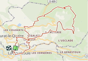
Tour Zu Fuß von 14,1 km verfügbar auf Auvergne-Rhone-Alpen, Puy-de-Dôme, La Bourboule. Diese Tour wird von v.rabot vorgeschlagen.
Beschreibung
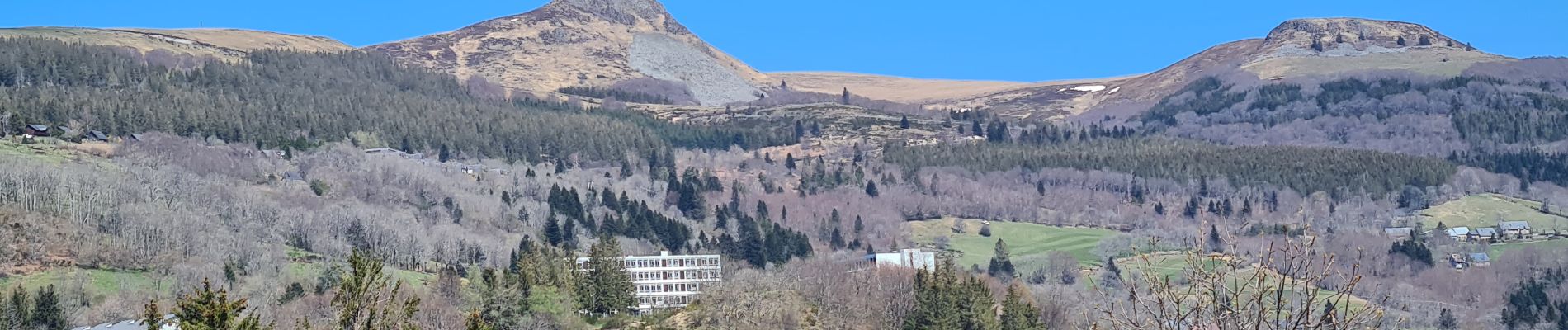
Nous devions faire un jour cette randonnée avec Lilia, la vie ne l'a pas permis, je l'ai donc effectué seul, c'est une des plus belle randonnées que j'ai effectuée. Magnifique vue sur la Bourboule depuis la Roche des fées, passage dans une belle forêt de pins près du parcours sportif, magnifique vue de la Banne d'Ordanche qui vous permet d'admirer le sancy, le puy de Dôme, etc.., pensez à vous retourner pour admirer le paysage, passage dans une forêt de hêtres, retour sur la Bourboule par un chemin goudronnée sans circulation mais qui permet d'admirer la vue sans trop de risque, méfiez vous cependant du gravillon qui peut ripper sous les pieds. Au final éclairage différent sur La Bourboule.
Ort
Kommentare
Touren in der Umgebung
![Tour Wandern Saint-Sauves-d'Auvergne - St_Sauves_Chateauneuf - Photo](https://media.geolcdn.com/t/375/260/5b40d0cb-0279-49d3-aedd-b2d33d081712.jpg&format=jpg&maxdim=2)
![Wandern Wandern](https://static1.geolcdn.com/sitytour/trail-icons/101.png)
Wandern
![](/images/other/stat-length.png)
![](https://static1.geolcdn.com/siteimages/upload/files/16400158638029165_repeat_loop_refresh_sync_direction_icon.png)
![Tour Wandern La Tour-d'Auvergne - Tour_Auvergne_Chambourguet - Photo](https://media.geolcdn.com/t/375/260/89f1026c-dcfd-4eec-ac48-a164d692d4ad.jpg&format=jpg&maxdim=2)
![Wandern Wandern](https://static1.geolcdn.com/sitytour/trail-icons/101.png)
Wandern
![](/images/other/stat-length.png)
![](https://static1.geolcdn.com/siteimages/upload/files/16400158638029165_repeat_loop_refresh_sync_direction_icon.png)
![Tour Wandern Murat-le-Quaire - De Murat le Quaire au Puy Gros - Photo](https://media.geolcdn.com/t/375/260/ext.jpg?maxdim=2&url=https%3A%2F%2Fservices.sitytrail.com%2FGeolivesWS%2FDownloadMedia.ashx%3FTrailID%3D173047%26Media%3D14567_5.jpg)
![Wandern Wandern](https://static1.geolcdn.com/sitytour/trail-icons/101.png)
Wandern
![](/images/other/stat-length.png)
![](https://static1.geolcdn.com/siteimages/upload/files/16400158638029165_repeat_loop_refresh_sync_direction_icon.png)
![Tour Wandern La Bourboule - Bourboule_Vendeix_Charlannes - Photo](https://media.geolcdn.com/t/375/260/974b84fb-245b-4e5c-88f2-976a8059b2eb.jpg&format=jpg&maxdim=2)
![Wandern Wandern](https://static1.geolcdn.com/sitytour/trail-icons/101.png)
Wandern
![](/images/other/stat-length.png)
![](https://static1.geolcdn.com/siteimages/upload/files/16400158638029165_repeat_loop_refresh_sync_direction_icon.png)
![Tour Wandern Murat-le-Quaire - Murat_Quaire_Ordanche - Photo](https://media.geolcdn.com/t/375/260/b09d93ea-88df-4f42-8ffa-b565d95a8b44.jpg&format=jpg&maxdim=2)
![Wandern Wandern](https://static1.geolcdn.com/sitytour/trail-icons/101.png)
Wandern
![](/images/other/stat-length.png)
![](https://static1.geolcdn.com/siteimages/upload/files/16400158638029165_repeat_loop_refresh_sync_direction_icon.png)
![Tour Wandern Murat-le-Quaire - La Banne d'Ordanche - Photo](https://media.geolcdn.com/t/375/260/ext.jpg?maxdim=2&url=https%3A%2F%2Fservices.sitytrail.com%2FGeolivesWS%2FDownloadMedia.ashx%3FTrailID%3D147717%26Media%3D20120817123608.jpg)
![Wandern Wandern](https://static1.geolcdn.com/sitytour/trail-icons/101.png)
Wandern
![](/images/other/stat-length.png)
![](https://static1.geolcdn.com/siteimages/upload/files/16400158638029165_repeat_loop_refresh_sync_direction_icon.png)
![Tour Wandern Murat-le-Quaire - Banne d’Ordanches - Photo](https://media.geolcdn.com/t/375/260/d96c37de-8bd1-4492-8cba-24f6951ae64e.jpg&format=jpg&maxdim=2)
![Wandern Wandern](https://static1.geolcdn.com/sitytour/trail-icons/101.png)
Wandern
![](/images/other/stat-length.png)
![](https://static1.geolcdn.com/siteimages/upload/files/16400158638029165_repeat_loop_refresh_sync_direction_icon.png)
![Tour Zu Fuß La Tour-d'Auvergne - Chambourguet - Photo](https://media.geolcdn.com/t/375/260/cae5925b-61ac-47d4-b021-c5bfebecd2dc.jpeg&format=jpg&maxdim=2)
![Zu Fuß Zu Fuß](https://static1.geolcdn.com/sitytour/trail-icons/100.png)
Zu Fuß
![](/images/other/stat-length.png)
![](https://static1.geolcdn.com/siteimages/upload/files/16400158638029165_repeat_loop_refresh_sync_direction_icon.png)
![Tour Zu Fuß Saint-Sauves-d'Auvergne - De la Dordogne aux volcans - Photo](https://media.geolcdn.com/t/375/260/ae8fc4f5-d959-4ad2-96df-a2429d0f6cda.jpeg&format=jpg&maxdim=2)
![Zu Fuß Zu Fuß](https://static1.geolcdn.com/sitytour/trail-icons/100.png)
Zu Fuß
![](/images/other/stat-length.png)
![](https://static1.geolcdn.com/siteimages/upload/files/16400158638029165_repeat_loop_refresh_sync_direction_icon.png)