![](/images/other/stat-length.png)
![Tour Wandern Revin - Laifour-Montherme - Photo](https://media.geolcdn.com/t/1900/400/ext.pjpeg?maxdim=2&url=https%3A%2F%2Fstatic1.geolcdn.com%2Fsiteimages%2Fupload%2Ffiles%2F1553511878bg_sport_marche.png)
Laifour-Montherme
Eric_Alu
Benutzer
![Länge](/images/other/stat-length.png)
Länge
21 km
![Maximale Höhe](https://static1.geolcdn.com/siteimages/upload/files/1508320355ic_sort_altitude_max_24dp.png)
Maximale Höhe
374 m
![Positive Höhendifferenz](https://static1.geolcdn.com/siteimages/upload/files/1508320355ic_sort_den_pos_24dp.png)
Positive Höhendifferenz
657 m
![Km-Effort](/images/other/stat-length.png)
Km-Effort
30 km
![Min. Höhe](https://static1.geolcdn.com/siteimages/upload/files/1508320355ic_sort_altitude_min_24dp.png)
Min. Höhe
131 m
![Negative Höhendifferenz](https://static1.geolcdn.com/siteimages/upload/files/1508320355ic_sort_den_neg_24dp.png)
Negative Höhendifferenz
657 m
![Boucle](https://static1.geolcdn.com/siteimages/upload/files/16400158638029165_repeat_loop_refresh_sync_direction_icon.png)
Boucle
Nein
Erstellungsdatum :
2014-12-10 00:00:00.0
Letzte Änderung :
2014-12-10 00:00:00.0
![Wandern](https://static1.geolcdn.com/sitytour/trail-icons/101.png)
8h08
Schwierigkeit : Schwierig
![Scannen Sie diesen QR-Code, um die Tour in der SityTrail-Anwendung zu öffnen](https://capi.geolives.com/qq0zvz2zws4bq2lad0pu/sitytour/trails/273073/qr.png?size=200)
Kostenlosegpshiking-Anwendung
Über SityTrail
Tour Wandern von 21 km verfügbar auf Großer Osten, Ardennes, Revin. Diese Tour wird von Eric_Alu vorgeschlagen.
Beschreibung
Petite commune Revin (Laifour )
Monthermé, St Remy Laval Dieu, Quatre fils Aymon, Chateau Regnault, Roches aux sept villages, Port Fluviale Monthermé.
Ort
Land:
France
Region :
Großer Osten
Abteilung/Provinz :
Ardennes
Kommune :
Revin
Standort:
Unknown
Gehen Sie:(Dec)
Gehen Sie:(UTM)
622521 ; 5529659 (31U) N.
Kommentare
Touren in der Umgebung
![Tour Wandern Monthermé - De Monthermé à Bogny sur Meuse par les sentiers de crêtes - Photo](https://media.geolcdn.com/t/375/260/ext.jpg?maxdim=2&url=https%3A%2F%2Fservices.sitytrail.com%2FGeolivesWS%2FDownloadMedia.ashx%3FTrailID%3D109030%26Media%3D2990_6.jpg)
![Wandern Wandern](https://static1.geolcdn.com/sitytour/trail-icons/101.png)
De Monthermé à Bogny sur Meuse par les sentiers de crêtes
Wandern
Schwierig
(2)
Monthermé,
Großer Osten,
Ardennes,
France
![](/images/other/stat-length.png)
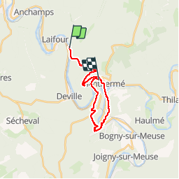
14,6 km | 23 km-effort
5h 0min
![](https://static1.geolcdn.com/siteimages/upload/files/16400158638029165_repeat_loop_refresh_sync_direction_icon.png)
Ja
![Tour Wandern Monthermé - La roche 7H Monthermé - Photo](https://media.geolcdn.com/t/375/260/9f5bae53-ca7e-45f9-9b5d-eda45fb0ca79.jpg&format=jpg&maxdim=2)
![Wandern Wandern](https://static1.geolcdn.com/sitytour/trail-icons/101.png)
La roche 7H Monthermé
Wandern
Medium
Monthermé,
Großer Osten,
Ardennes,
France
![](/images/other/stat-length.png)
5,9 km | 9 km-effort
2h 24min
![](https://static1.geolcdn.com/siteimages/upload/files/16400158638029165_repeat_loop_refresh_sync_direction_icon.png)
Ja
![Tour Wandern Monthermé - les woiries mercredi - Photo](https://media.geolcdn.com/t/375/260/d0196d84-41f0-4a44-947d-440912977a47.jpg&format=jpg&maxdim=2)
![Wandern Wandern](https://static1.geolcdn.com/sitytour/trail-icons/101.png)
les woiries mercredi
Wandern
Medium
Monthermé,
Großer Osten,
Ardennes,
France
![](/images/other/stat-length.png)
9,6 km | 12,7 km-effort
3h 37min
![](https://static1.geolcdn.com/siteimages/upload/files/16400158638029165_repeat_loop_refresh_sync_direction_icon.png)
Nein
![Tour Wandern Monthermé - Monthermé 22,7 km tour des rochers - Photo](https://media.geolcdn.com/t/375/260/6faf8d21-8c16-4737-b87b-be715fc8c814.jpg&format=jpg&maxdim=2)
![Wandern Wandern](https://static1.geolcdn.com/sitytour/trail-icons/101.png)
Monthermé 22,7 km tour des rochers
Wandern
Schwierig
Monthermé,
Großer Osten,
Ardennes,
France
![](/images/other/stat-length.png)
23 km | 36 km-effort
8h 20min
![](https://static1.geolcdn.com/siteimages/upload/files/16400158638029165_repeat_loop_refresh_sync_direction_icon.png)
Ja
![Tour Wandern Monthermé - Monthermé - Photo](https://media.geolcdn.com/t/375/260/1167704e-b918-4908-a8da-997965903325.jpg&format=jpg&maxdim=2)
![Wandern Wandern](https://static1.geolcdn.com/sitytour/trail-icons/101.png)
![Tour Wandern Revin - de Layfour à Anchamps - Photo](https://media.geolcdn.com/t/375/260/6644a90b-6b10-4064-893f-3442ceb4d9e6.jpg&format=jpg&maxdim=2)
![Wandern Wandern](https://static1.geolcdn.com/sitytour/trail-icons/101.png)
de Layfour à Anchamps
Wandern
Sehr schwierig
Revin,
Großer Osten,
Ardennes,
France
![](/images/other/stat-length.png)
15,2 km | 20 km-effort
4h 1min
![](https://static1.geolcdn.com/siteimages/upload/files/16400158638029165_repeat_loop_refresh_sync_direction_icon.png)
Nein
![Tour Wandern Monthermé - AUTOUR DE MONTHERMÉ, la boucle de la Meuse - Photo](https://media.geolcdn.com/t/375/260/7078bc98-043e-41d8-8080-5c4275522860.jpg&format=jpg&maxdim=2)
![Wandern Wandern](https://static1.geolcdn.com/sitytour/trail-icons/101.png)
AUTOUR DE MONTHERMÉ, la boucle de la Meuse
Wandern
Sehr schwierig
Monthermé,
Großer Osten,
Ardennes,
France
![](/images/other/stat-length.png)
14,9 km | 24 km-effort
5h 5min
![](https://static1.geolcdn.com/siteimages/upload/files/16400158638029165_repeat_loop_refresh_sync_direction_icon.png)
Ja
![Tour Wandern Les Mazures - 2022-05-16_12h48m40_SityTrail - 3244407 - dm-par-la-meuse-2022 - Photo](https://media.geolcdn.com/t/375/260/ext.jpg?maxdim=2&url=https%3A%2F%2Fstatic1.geolcdn.com%2Fsiteimages%2Fupload%2Ffiles%2F1553511878bg_sport_marche.png)
![Wandern Wandern](https://static1.geolcdn.com/sitytour/trail-icons/101.png)
2022-05-16_12h48m40_SityTrail - 3244407 - dm-par-la-meuse-2022
Wandern
Sehr schwierig
(1)
Les Mazures,
Großer Osten,
Ardennes,
France
![](/images/other/stat-length.png)
14,1 km | 19,2 km-effort
4h 21min
![](https://static1.geolcdn.com/siteimages/upload/files/16400158638029165_repeat_loop_refresh_sync_direction_icon.png)
Ja
![Tour Wandern Revin - 2022-04-25_16h18m48_SityTrail - 2733173 - revinxmalgre-tout4x2021x04x03 (1) (1) - Photo](https://media.geolcdn.com/t/375/260/ext.jpg?maxdim=2&url=https%3A%2F%2Fstatic1.geolcdn.com%2Fsiteimages%2Fupload%2Ffiles%2F1553511878bg_sport_marche.png)
![Wandern Wandern](https://static1.geolcdn.com/sitytour/trail-icons/101.png)
2022-04-25_16h18m48_SityTrail - 2733173 - revinxmalgre-tout4x2021x04x03 (1) (1)
Wandern
Schwierig
(1)
Revin,
Großer Osten,
Ardennes,
France
![](/images/other/stat-length.png)
9,5 km | 12,1 km-effort
2h 44min
![](https://static1.geolcdn.com/siteimages/upload/files/16400158638029165_repeat_loop_refresh_sync_direction_icon.png)
Ja
trop pratique, complètement convaincu après 5 jours d'usage