![](/images/other/stat-length.png)
![Tour Zu Fuß Auriol - encanaux infernets cauvin - Photo](https://media.geolcdn.com/t/1900/400/230b04a2-6e92-4920-ae74-dab2a091f8ef.jpg&format=pjpeg&maxdim=2)
encanaux infernets cauvin
cdanielrando
Benutzer
![Länge](/images/other/stat-length.png)
Länge
12,8 km
![Maximale Höhe](https://static1.geolcdn.com/siteimages/upload/files/1508320355ic_sort_altitude_max_24dp.png)
Maximale Höhe
793 m
![Positive Höhendifferenz](https://static1.geolcdn.com/siteimages/upload/files/1508320355ic_sort_den_pos_24dp.png)
Positive Höhendifferenz
643 m
![Km-Effort](/images/other/stat-length.png)
Km-Effort
21 km
![Min. Höhe](https://static1.geolcdn.com/siteimages/upload/files/1508320355ic_sort_altitude_min_24dp.png)
Min. Höhe
275 m
![Negative Höhendifferenz](https://static1.geolcdn.com/siteimages/upload/files/1508320355ic_sort_den_neg_24dp.png)
Negative Höhendifferenz
643 m
![Boucle](https://static1.geolcdn.com/siteimages/upload/files/16400158638029165_repeat_loop_refresh_sync_direction_icon.png)
Boucle
Ja
Erstellungsdatum :
2021-04-01 06:22:49.921
Letzte Änderung :
2021-04-01 06:28:50.342
![Zu Fuß](https://static1.geolcdn.com/sitytour/trail-icons/100.png)
4h50
Schwierigkeit : Medium
![Scannen Sie diesen QR-Code, um die Tour in der SityTrail-Anwendung zu öffnen](https://capi.geolives.com/qq0zvz2zws4bq2lad0pu/sitytour/trails/2730031/qr.png?size=200)
Kostenlosegpshiking-Anwendung
Über SityTrail
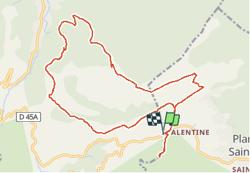
Tour Zu Fuß von 12,8 km verfügbar auf Provence-Alpes-Côte d'Azur, Bouches-du-Rhône, Auriol. Diese Tour wird von cdanielrando vorgeschlagen.
Beschreibung
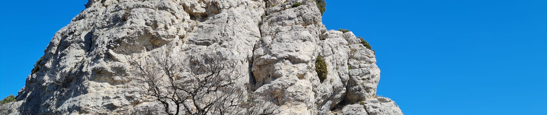
Belle randonnée, avec vue sur Le Garlaban, la ste Victoire; le mt Olympe, la chaine de la ste Baume. De la tour de Cauvin, on peut voir la presque totalité du circuit, l'effort est bien récompensé
Ort
Land:
France
Region :
Provence-Alpes-Côte d'Azur
Abteilung/Provinz :
Bouches-du-Rhône
Kommune :
Auriol
Standort:
Unknown
Gehen Sie:(Dec)
Gehen Sie:(UTM)
718077 ; 4801121 (31T) N.
Kommentare
Touren in der Umgebung
![Tour Wandern Gémenos - St Pons Le Fauge Glacière - Photo](https://media.geolcdn.com/t/375/260/ext.jpg?maxdim=2&url=https%3A%2F%2Fservices.sitytrail.com%2FGeolivesWS%2FDownloadMedia.ashx%3FTrailID%3D954893%26Media%3Dfix__20180430171638.jpg)
![Wandern Wandern](https://static1.geolcdn.com/sitytour/trail-icons/101.png)
St Pons Le Fauge Glacière
Wandern
Schwierig
(1)
Gémenos,
Provence-Alpes-Côte d'Azur,
Bouches-du-Rhône,
France
![](/images/other/stat-length.png)
11,7 km | 18,6 km-effort
3h 56min
![](https://static1.geolcdn.com/siteimages/upload/files/16400158638029165_repeat_loop_refresh_sync_direction_icon.png)
Ja
![Tour Wandern Gémenos - dent de roque forcade. cauvin.bertagne. 2 avril 2018 - Photo](https://media.geolcdn.com/t/375/260/ext.jpg?maxdim=2&url=https%3A%2F%2Fservices.sitytrail.com%2FGeolivesWS%2FDownloadMedia.ashx%3FTrailID%3D935467%26Media%3Dfix__20180402124207.jpg)
![Wandern Wandern](https://static1.geolcdn.com/sitytour/trail-icons/101.png)
dent de roque forcade. cauvin.bertagne. 2 avril 2018
Wandern
Medium
(1)
Gémenos,
Provence-Alpes-Côte d'Azur,
Bouches-du-Rhône,
France
![](/images/other/stat-length.png)
12,7 km | 20 km-effort
4h 31min
![](https://static1.geolcdn.com/siteimages/upload/files/16400158638029165_repeat_loop_refresh_sync_direction_icon.png)
Ja
![Tour Wandern Auriol - la crete des infernets - Photo](https://media.geolcdn.com/t/375/260/ext.jpg?maxdim=2&url=https%3A%2F%2Fservices.sitytrail.com%2FGeolivesWS%2FDownloadMedia.ashx%3FTrailID%3D867921%26Media%3Dfix__20171126111949.jpg)
![Wandern Wandern](https://static1.geolcdn.com/sitytour/trail-icons/101.png)
la crete des infernets
Wandern
Schwierig
(1)
Auriol,
Provence-Alpes-Côte d'Azur,
Bouches-du-Rhône,
France
![](/images/other/stat-length.png)
8,6 km | 14 km-effort
3h 22min
![](https://static1.geolcdn.com/siteimages/upload/files/16400158638029165_repeat_loop_refresh_sync_direction_icon.png)
Ja
![Tour Wandern Gémenos - autour de Saint pons - Photo](https://media.geolcdn.com/t/375/260/ext.jpg?maxdim=2&url=https%3A%2F%2Fservices.sitytrail.com%2FGeolivesWS%2FDownloadMedia.ashx%3FTrailID%3D723506%26Media%3Dfix__20170330154755.jpg)
![Wandern Wandern](https://static1.geolcdn.com/sitytour/trail-icons/101.png)
autour de Saint pons
Wandern
Einfach
(1)
Gémenos,
Provence-Alpes-Côte d'Azur,
Bouches-du-Rhône,
France
![](/images/other/stat-length.png)
11,6 km | 16,1 km-effort
3h 46min
![](https://static1.geolcdn.com/siteimages/upload/files/16400158638029165_repeat_loop_refresh_sync_direction_icon.png)
Ja
![Tour Wandern Gémenos - Autour des Dents de Roque Forcade, Tour de Cauvin - Photo](https://media.geolcdn.com/t/375/260/ext.jpg?maxdim=2&url=https%3A%2F%2Fservices.sitytrail.com%2FGeolivesWS%2FDownloadMedia.ashx%3FTrailID%3D107626%26Media%3D12610_1.jpg)
![Wandern Wandern](https://static1.geolcdn.com/sitytour/trail-icons/101.png)
Autour des Dents de Roque Forcade, Tour de Cauvin
Wandern
Schwierig
(1)
Gémenos,
Provence-Alpes-Côte d'Azur,
Bouches-du-Rhône,
France
![](/images/other/stat-length.png)
7,6 km | 11,7 km-effort
3h 15min
![](https://static1.geolcdn.com/siteimages/upload/files/16400158638029165_repeat_loop_refresh_sync_direction_icon.png)
Ja
![Tour Mountainbike Gémenos - Gémenos - La Grande Baume - Photo](https://media.geolcdn.com/t/375/260/ext.jpg?maxdim=2&url=https%3A%2F%2Fservices.sitytrail.com%2FGeolivesWS%2FDownloadMedia.ashx%3FTrailID%3D104196%26Media%3D7328_1.jpg)
![Mountainbike Mountainbike](https://static1.geolcdn.com/sitytour/trail-icons/202.png)
Gémenos - La Grande Baume
Mountainbike
Schwierig
(1)
Gémenos,
Provence-Alpes-Côte d'Azur,
Bouches-du-Rhône,
France
![](/images/other/stat-length.png)
18,4 km | 29 km-effort
3h 30min
![](https://static1.geolcdn.com/siteimages/upload/files/16400158638029165_repeat_loop_refresh_sync_direction_icon.png)
Ja
![Tour Wandern Plan-d'Aups-Sainte-Baume - La Grotte aux oiseaux - Plan d'Aups - Photo](https://media.geolcdn.com/t/375/260/ext.jpg?maxdim=2&url=https%3A%2F%2Fservices.sitytrail.com%2FGeolivesWS%2FDownloadMedia.ashx%3FTrailID%3D103826%26Media%3D6600_1.jpg)
![Wandern Wandern](https://static1.geolcdn.com/sitytour/trail-icons/101.png)
La Grotte aux oiseaux - Plan d'Aups
Wandern
Medium
(1)
Plan-d'Aups-Sainte-Baume,
Provence-Alpes-Côte d'Azur,
Var,
France
![](/images/other/stat-length.png)
8,8 km | 12,5 km-effort
2h 30min
![](https://static1.geolcdn.com/siteimages/upload/files/16400158638029165_repeat_loop_refresh_sync_direction_icon.png)
Ja
![Tour Wandern Gémenos - Parc de St Pons anc. Glacière - Photo](https://media.geolcdn.com/t/375/260/01d544fc-e25f-41ba-b83a-9276d30a703d.jpg&format=jpg&maxdim=2)
![Wandern Wandern](https://static1.geolcdn.com/sitytour/trail-icons/101.png)
Parc de St Pons anc. Glacière
Wandern
Medium
Gémenos,
Provence-Alpes-Côte d'Azur,
Bouches-du-Rhône,
France
![](/images/other/stat-length.png)
14,1 km | 23 km-effort
4h 2min
![](https://static1.geolcdn.com/siteimages/upload/files/16400158638029165_repeat_loop_refresh_sync_direction_icon.png)
Ja
![Tour Wandern Saint-Zacharie - Sources des Nayes - Photo](https://media.geolcdn.com/t/375/260/f10876bf-7b9c-4295-a050-83953c85f7a8.jpg&format=jpg&maxdim=2)
![Wandern Wandern](https://static1.geolcdn.com/sitytour/trail-icons/101.png)
Sources des Nayes
Wandern
Medium
Saint-Zacharie,
Provence-Alpes-Côte d'Azur,
Var,
France
![](/images/other/stat-length.png)
7,6 km | 9,6 km-effort
1h 47min
![](https://static1.geolcdn.com/siteimages/upload/files/16400158638029165_repeat_loop_refresh_sync_direction_icon.png)
Ja