![](/images/other/stat-length.png)
![Tour Wandern Flassans-sur-Issole - flassans-sur-issole - Photo](https://media.geolcdn.com/t/1900/400/272127f8-651e-43b0-864e-2373ba32a41c.jpg&format=pjpeg&maxdim=2)
flassans-sur-issole
affinetataille
Benutzer GUIDE
![Länge](/images/other/stat-length.png)
Länge
13,5 km
![Maximale Höhe](https://static1.geolcdn.com/siteimages/upload/files/1508320355ic_sort_altitude_max_24dp.png)
Maximale Höhe
318 m
![Positive Höhendifferenz](https://static1.geolcdn.com/siteimages/upload/files/1508320355ic_sort_den_pos_24dp.png)
Positive Höhendifferenz
216 m
![Km-Effort](/images/other/stat-length.png)
Km-Effort
16,4 km
![Min. Höhe](https://static1.geolcdn.com/siteimages/upload/files/1508320355ic_sort_altitude_min_24dp.png)
Min. Höhe
204 m
![Negative Höhendifferenz](https://static1.geolcdn.com/siteimages/upload/files/1508320355ic_sort_den_neg_24dp.png)
Negative Höhendifferenz
215 m
![Boucle](https://static1.geolcdn.com/siteimages/upload/files/16400158638029165_repeat_loop_refresh_sync_direction_icon.png)
Boucle
Ja
Erstellungsdatum :
2021-03-31 21:17:26.265
Letzte Änderung :
2021-06-03 23:10:21.693
![Wandern](https://static1.geolcdn.com/sitytour/trail-icons/101.png)
5h30
Schwierigkeit : Einfach
![Scannen Sie diesen QR-Code, um die Tour in der SityTrail-Anwendung zu öffnen](https://capi.geolives.com/qq0zvz2zws4bq2lad0pu/sitytour/trails/2729967/qr.png?size=200)
Kostenlosegpshiking-Anwendung
Über SityTrail
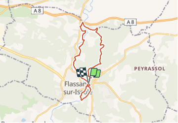
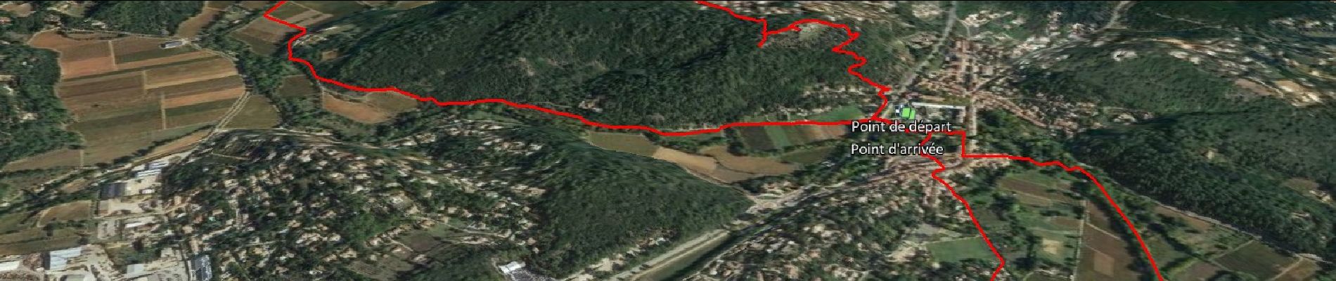
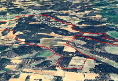
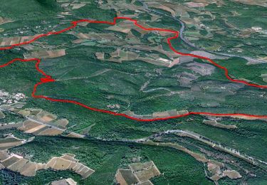
Tour Wandern von 13,5 km verfügbar auf Provence-Alpes-Côte d'Azur, Var, Flassans-sur-Issole. Diese Tour wird von affinetataille vorgeschlagen.
Beschreibung
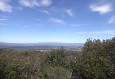
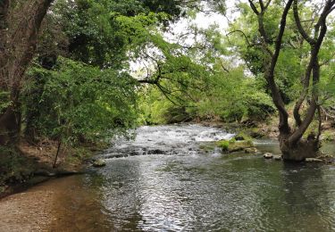
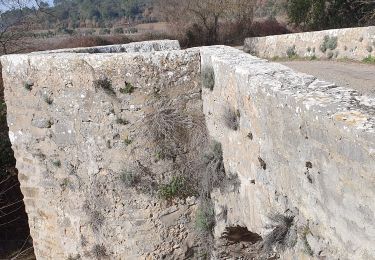
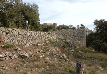
Promenade au bord de l'Issole puis à travers les vignes pour finir par la visite des ruines du Chateau de Pontevès.
Tracé très facile ... Une seule cote avant le chateau de Ponteves
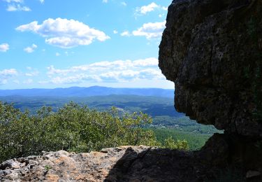
Ort
Land:
France
Region :
Provence-Alpes-Côte d'Azur
Abteilung/Provinz :
Var
Kommune :
Flassans-sur-Issole
Standort:
Unknown
Gehen Sie:(Dec)
Gehen Sie:(UTM)
274876 ; 4805641 (32T) N.
Kommentare
Touren in der Umgebung
![Tour Wandern Flassans-sur-Issole - SityTrail - Flassans rando Redon 2 - Photo](https://media.geolcdn.com/t/375/260/269bbef5-fac1-44bc-8839-608da7882967.jpg&format=jpg&maxdim=2)
![Wandern Wandern](https://static1.geolcdn.com/sitytour/trail-icons/101.png)
SityTrail - Flassans rando Redon 2
Wandern
Einfach
(1)
Flassans-sur-Issole,
Provence-Alpes-Côte d'Azur,
Var,
France
![](/images/other/stat-length.png)
15,5 km | 19,3 km-effort
6h 0min
![](https://static1.geolcdn.com/siteimages/upload/files/16400158638029165_repeat_loop_refresh_sync_direction_icon.png)
Ja
![Tour Wandern Flassans-sur-Issole - SityTrail - Flassans Chau de Pontéves - Photo](https://media.geolcdn.com/t/375/260/f6b89427-8dbe-40a1-8c27-01bf04e99ddc.jpg&format=jpg&maxdim=2)
![Wandern Wandern](https://static1.geolcdn.com/sitytour/trail-icons/101.png)
SityTrail - Flassans Chau de Pontéves
Wandern
Sehr schwierig
(1)
Flassans-sur-Issole,
Provence-Alpes-Côte d'Azur,
Var,
France
![](/images/other/stat-length.png)
15,3 km | 19,9 km-effort
4h 31min
![](https://static1.geolcdn.com/siteimages/upload/files/16400158638029165_repeat_loop_refresh_sync_direction_icon.png)
Ja
![Tour Wandern Besse-sur-Issole - Ermitage de Saint Quinis 16.3.24 - Photo](https://media.geolcdn.com/t/375/260/dc71aa2c-2a52-4e81-901f-c8126950b626.jpg&format=jpg&maxdim=2)
![Wandern Wandern](https://static1.geolcdn.com/sitytour/trail-icons/101.png)
Ermitage de Saint Quinis 16.3.24
Wandern
Einfach
Besse-sur-Issole,
Provence-Alpes-Côte d'Azur,
Var,
France
![](/images/other/stat-length.png)
10 km | 15,2 km-effort
3h 0min
![](https://static1.geolcdn.com/siteimages/upload/files/16400158638029165_repeat_loop_refresh_sync_direction_icon.png)
Ja
![Tour Wandern Besse-sur-Issole - Boucle entre Besse et Ste Anastasie sur Issole - Photo](https://media.geolcdn.com/t/375/260/06e3e46b-800e-4c1c-9551-df99b428495c.jpg&format=jpg&maxdim=2)
![Wandern Wandern](https://static1.geolcdn.com/sitytour/trail-icons/101.png)
Boucle entre Besse et Ste Anastasie sur Issole
Wandern
Medium
Besse-sur-Issole,
Provence-Alpes-Côte d'Azur,
Var,
France
![](/images/other/stat-length.png)
14,8 km | 18,9 km-effort
4h 17min
![](https://static1.geolcdn.com/siteimages/upload/files/16400158638029165_repeat_loop_refresh_sync_direction_icon.png)
Ja
![Tour Wandern Flassans-sur-Issole - Chateau de Ponteves - Flassans - Photo](https://media.geolcdn.com/t/375/260/ext.jpg?maxdim=2&url=https%3A%2F%2Fstatic1.geolcdn.com%2Fsiteimages%2Fupload%2Ffiles%2F1553511878bg_sport_marche.png)
![Wandern Wandern](https://static1.geolcdn.com/sitytour/trail-icons/101.png)
Chateau de Ponteves - Flassans
Wandern
Einfach
(2)
Flassans-sur-Issole,
Provence-Alpes-Côte d'Azur,
Var,
France
![](/images/other/stat-length.png)
11,3 km | 13,9 km-effort
3h 37min
![](https://static1.geolcdn.com/siteimages/upload/files/16400158638029165_repeat_loop_refresh_sync_direction_icon.png)
Ja
![Tour Wandern Flassans-sur-Issole - flassans sur Issole - Photo](https://media.geolcdn.com/t/375/260/3227ace2-07fe-4c77-83e9-c6eb636bf68c.jpg&format=jpg&maxdim=2)
![Wandern Wandern](https://static1.geolcdn.com/sitytour/trail-icons/101.png)
flassans sur Issole
Wandern
Medium
Flassans-sur-Issole,
Provence-Alpes-Côte d'Azur,
Var,
France
![](/images/other/stat-length.png)
11,4 km | 13,9 km-effort
2h 53min
![](https://static1.geolcdn.com/siteimages/upload/files/16400158638029165_repeat_loop_refresh_sync_direction_icon.png)
Ja
![Tour Wandern Flassans-sur-Issole - Château des PONTEVES-12-12-22 - Photo](https://media.geolcdn.com/t/375/260/29de5f3f-3457-4257-8be5-b4f3b9815fc2.jpg&format=jpg&maxdim=2)
![Wandern Wandern](https://static1.geolcdn.com/sitytour/trail-icons/101.png)
Château des PONTEVES-12-12-22
Wandern
Medium
Flassans-sur-Issole,
Provence-Alpes-Côte d'Azur,
Var,
France
![](/images/other/stat-length.png)
16,8 km | 22 km-effort
4h 27min
![](https://static1.geolcdn.com/siteimages/upload/files/16400158638029165_repeat_loop_refresh_sync_direction_icon.png)
Ja
![Wandern Wandern](https://static1.geolcdn.com/sitytour/trail-icons/101.png)
Besse sur Issole - Lac - Barre et Chapelle de St Quinis
Wandern
Einfach
Besse-sur-Issole,
Provence-Alpes-Côte d'Azur,
Var,
France
![](/images/other/stat-length.png)
16,7 km | 24 km-effort
4h 35min
![](https://static1.geolcdn.com/siteimages/upload/files/16400158638029165_repeat_loop_refresh_sync_direction_icon.png)
Ja
![Tour Wandern Flassans-sur-Issole - Flassans - Photo](https://media.geolcdn.com/t/375/260/00c25a40-8d62-4837-a8af-47e610d2320c.jpg&format=jpg&maxdim=2)
![Wandern Wandern](https://static1.geolcdn.com/sitytour/trail-icons/101.png)
Flassans
Wandern
Sehr schwierig
Flassans-sur-Issole,
Provence-Alpes-Côte d'Azur,
Var,
France
![](/images/other/stat-length.png)
16,4 km | 19,7 km-effort
4h 48min
![](https://static1.geolcdn.com/siteimages/upload/files/16400158638029165_repeat_loop_refresh_sync_direction_icon.png)
Ja