![](/images/other/stat-length.png)
![Tour Wandern Trooz - Magnée par le Bois des jonquilles - Photo](https://media.geolcdn.com/t/1900/400/8df2e005-047b-4f0e-98a7-f24779628e2e.jpg&format=pjpeg&maxdim=2)
Magnée par le Bois des jonquilles
amyrose
Benutzer
![Länge](/images/other/stat-length.png)
Länge
8,4 km
![Maximale Höhe](https://static1.geolcdn.com/siteimages/upload/files/1508320355ic_sort_altitude_max_24dp.png)
Maximale Höhe
259 m
![Positive Höhendifferenz](https://static1.geolcdn.com/siteimages/upload/files/1508320355ic_sort_den_pos_24dp.png)
Positive Höhendifferenz
244 m
![Km-Effort](/images/other/stat-length.png)
Km-Effort
11,7 km
![Min. Höhe](https://static1.geolcdn.com/siteimages/upload/files/1508320355ic_sort_altitude_min_24dp.png)
Min. Höhe
120 m
![Negative Höhendifferenz](https://static1.geolcdn.com/siteimages/upload/files/1508320355ic_sort_den_neg_24dp.png)
Negative Höhendifferenz
247 m
![Boucle](https://static1.geolcdn.com/siteimages/upload/files/16400158638029165_repeat_loop_refresh_sync_direction_icon.png)
Boucle
Ja
Erstellungsdatum :
2021-03-30 07:32:16.0
Letzte Änderung :
2021-04-16 16:03:33.075
![Wandern](https://static1.geolcdn.com/sitytour/trail-icons/101.png)
2h05
Schwierigkeit : Unbekannt
![Scannen Sie diesen QR-Code, um die Tour in der SityTrail-Anwendung zu öffnen](https://capi.geolives.com/qq0zvz2zws4bq2lad0pu/sitytour/trails/2727688/qr.png?size=200)
Kostenlosegpshiking-Anwendung
Über SityTrail
Tour Wandern von 8,4 km verfügbar auf Wallonien, Lüttich, Trooz. Diese Tour wird von amyrose vorgeschlagen.
Beschreibung
Départ Forêt
Descendre à saint hadelin par le bois de Jonquilles aller à la route du bay bonnet en contournant la carrière remonter à magnée jusqu'au serres revenir à Forêt.
Ort
Land:
Belgium
Region :
Wallonien
Abteilung/Provinz :
Lüttich
Kommune :
Trooz
Standort:
Forêt
Gehen Sie:(Dec)
Gehen Sie:(UTM)
691138 ; 5607055 (31U) N.
Kommentare
Touren in der Umgebung
![Tour Wandern Chaudfontaine - RB-Lg-21_Chaudfontaine_via-racc-1-et-2 - Photo](https://media.geolcdn.com/t/375/260/ext.jpg?maxdim=2&url=https%3A%2F%2Fservices.sitytrail.com%2FGeolivesWS%2FDownloadMedia.ashx%3FTrailID%3D400756%26Media%3Db4e5d748-2e9a-46aa-887f-e41bafbe80d7.jpg)
![Wandern Wandern](https://static1.geolcdn.com/sitytour/trail-icons/101.png)
RB-Lg-21_Chaudfontaine_via-racc-1-et-2
Wandern
Schwierig
(9)
Chaudfontaine,
Wallonien,
Lüttich,
Belgium
![](/images/other/stat-length.png)
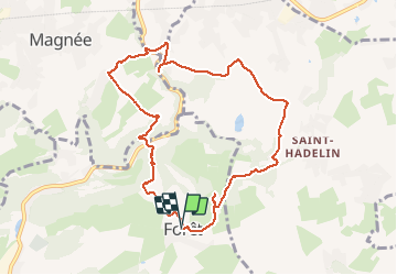
11,6 km | 16,5 km-effort
3h 45min
![](https://static1.geolcdn.com/siteimages/upload/files/16400158638029165_repeat_loop_refresh_sync_direction_icon.png)
Ja
![Tour Wandern Chaudfontaine - RB-Lg-21_Chaudfontaine - Photo](https://media.geolcdn.com/t/375/260/ext.jpg?maxdim=2&url=https%3A%2F%2Fservices.sitytrail.com%2FGeolivesWS%2FDownloadMedia.ashx%3FTrailID%3D400753%26Media%3D0173f844-fd8a-4443-984d-43fa65695365.jpg)
![Wandern Wandern](https://static1.geolcdn.com/sitytour/trail-icons/101.png)
RB-Lg-21_Chaudfontaine
Wandern
(14)
Chaudfontaine,
Wallonien,
Lüttich,
Belgium
![](/images/other/stat-length.png)
18 km | 26 km-effort
5h 56min
![](https://static1.geolcdn.com/siteimages/upload/files/16400158638029165_repeat_loop_refresh_sync_direction_icon.png)
Ja
![Tour Wandern Chaudfontaine - Chaudfontaine, Natura 2000 - Des sites qui valent le détour, Lg7 - Photo](https://media.geolcdn.com/t/375/260/ext.jpg?maxdim=2&url=https%3A%2F%2Fservices.sitytrail.com%2FGeolivesWS%2FDownloadMedia.ashx%3FTrailID%3D188128%26Media%3Df5c5efa3-ad1d-47ec-bc6a-d75c5f96ada1.JPG)
![Wandern Wandern](https://static1.geolcdn.com/sitytour/trail-icons/101.png)
Chaudfontaine, Natura 2000 - Des sites qui valent le détour, Lg7
Wandern
Schwierig
(14)
Chaudfontaine,
Wallonien,
Lüttich,
Belgium
![](/images/other/stat-length.png)
5,3 km | 8,7 km-effort
1h 48min
![](https://static1.geolcdn.com/siteimages/upload/files/16400158638029165_repeat_loop_refresh_sync_direction_icon.png)
Ja
![Tour Wandern Trooz - RB-Lg-03 - Entre Vesdre et Hoëgne - Photo](https://media.geolcdn.com/t/375/260/ext.jpg?maxdim=2&url=https%3A%2F%2Fservices.sitytrail.com%2FGeolivesWS%2FDownloadMedia.ashx%3FTrailID%3D179559%26Media%3Dcef2de81-7d4f-4fcd-9e9d-f315370fe61f.jpg)
![Wandern Wandern](https://static1.geolcdn.com/sitytour/trail-icons/101.png)
RB-Lg-03 - Entre Vesdre et Hoëgne
Wandern
Medium
(12)
Trooz,
Wallonien,
Lüttich,
Belgium
![](/images/other/stat-length.png)
22 km | 29 km-effort
6h 9min
![](https://static1.geolcdn.com/siteimages/upload/files/16400158638029165_repeat_loop_refresh_sync_direction_icon.png)
Ja
![Tour Wandern Fléron - 2024-06-16_18h18m53_1402.gpx.xml - Photo](https://media.geolcdn.com/t/375/260/65875cd7-f353-4090-b6ef-a8656311fae6.jpg&format=jpg&maxdim=2)
![Wandern Wandern](https://static1.geolcdn.com/sitytour/trail-icons/101.png)
2024-06-16_18h18m53_1402.gpx.xml
Wandern
Medium
(1)
Fléron,
Wallonien,
Lüttich,
Belgium
![](/images/other/stat-length.png)
9,8 km | 12,3 km-effort
2h 47min
![](https://static1.geolcdn.com/siteimages/upload/files/16400158638029165_repeat_loop_refresh_sync_direction_icon.png)
Ja
![Wandern Wandern](https://static1.geolcdn.com/sitytour/trail-icons/101.png)
20220307 - Saint-Hadelin 8.8 Km
Wandern
Medium
(1)
Olne,
Wallonien,
Lüttich,
Belgium
![](/images/other/stat-length.png)
8,4 km | 10,9 km-effort
2h 24min
![](https://static1.geolcdn.com/siteimages/upload/files/16400158638029165_repeat_loop_refresh_sync_direction_icon.png)
Ja
![Tour Wandern Trooz - 2022-02-03_17h57m35_BaladedeFraipont - Photo](https://media.geolcdn.com/t/375/260/a22be754-a7d6-4ac7-b88b-6e30a6735908.jpg&format=jpg&maxdim=2)
![Wandern Wandern](https://static1.geolcdn.com/sitytour/trail-icons/101.png)
2022-02-03_17h57m35_BaladedeFraipont
Wandern
Medium
(1)
Trooz,
Wallonien,
Lüttich,
Belgium
![](/images/other/stat-length.png)
12,3 km | 17,3 km-effort
3h 55min
![](https://static1.geolcdn.com/siteimages/upload/files/16400158638029165_repeat_loop_refresh_sync_direction_icon.png)
Ja
![Tour Wandern Trooz - 2021-05-16_08h02m48_1403 - Photo](https://media.geolcdn.com/t/375/260/d573d865-936c-49e5-ac73-8dda0a954532.jpg&format=jpg&maxdim=2)
![Wandern Wandern](https://static1.geolcdn.com/sitytour/trail-icons/101.png)
2021-05-16_08h02m48_1403
Wandern
Schwierig
(1)
Trooz,
Wallonien,
Lüttich,
Belgium
![](/images/other/stat-length.png)
10,1 km | 14,6 km-effort
3h 19min
![](https://static1.geolcdn.com/siteimages/upload/files/16400158638029165_repeat_loop_refresh_sync_direction_icon.png)
Ja
![Tour Wandern Olne - 2021-03-10_16h10m11_1409 - Photo](https://media.geolcdn.com/t/375/260/8c16a020-3972-4fd4-95a4-e68b814bf4ee.jpg&format=jpg&maxdim=2)
![Wandern Wandern](https://static1.geolcdn.com/sitytour/trail-icons/101.png)
2021-03-10_16h10m11_1409
Wandern
Medium
(3)
Olne,
Wallonien,
Lüttich,
Belgium
![](/images/other/stat-length.png)
11,7 km | 16,1 km-effort
3h 39min
![](https://static1.geolcdn.com/siteimages/upload/files/16400158638029165_repeat_loop_refresh_sync_direction_icon.png)
Ja