![](/images/other/stat-length.png)
![Tour Wandern Les Moutiers-en-Retz - De Prigny à la Guérivière - Photo](https://media.geolcdn.com/t/1900/400/732414e1-0d73-4bb4-8cbc-0e2adbd9a7b9.jpg&format=pjpeg&maxdim=2)
De Prigny à la Guérivière
neoroll44
Benutzer
![Länge](/images/other/stat-length.png)
Länge
7,8 km
![Maximale Höhe](https://static1.geolcdn.com/siteimages/upload/files/1508320355ic_sort_altitude_max_24dp.png)
Maximale Höhe
26 m
![Positive Höhendifferenz](https://static1.geolcdn.com/siteimages/upload/files/1508320355ic_sort_den_pos_24dp.png)
Positive Höhendifferenz
72 m
![Km-Effort](/images/other/stat-length.png)
Km-Effort
8,8 km
![Min. Höhe](https://static1.geolcdn.com/siteimages/upload/files/1508320355ic_sort_altitude_min_24dp.png)
Min. Höhe
2 m
![Negative Höhendifferenz](https://static1.geolcdn.com/siteimages/upload/files/1508320355ic_sort_den_neg_24dp.png)
Negative Höhendifferenz
72 m
![Boucle](https://static1.geolcdn.com/siteimages/upload/files/16400158638029165_repeat_loop_refresh_sync_direction_icon.png)
Boucle
Ja
Erstellungsdatum :
2021-03-27 17:38:27.311
Letzte Änderung :
2021-04-03 16:07:10.742
![Wandern](https://static1.geolcdn.com/sitytour/trail-icons/101.png)
2h00
Schwierigkeit : Einfach
![Scannen Sie diesen QR-Code, um die Tour in der SityTrail-Anwendung zu öffnen](https://capi.geolives.com/qq0zvz2zws4bq2lad0pu/sitytour/trails/2723845/qr.png?size=200)
Kostenlosegpshiking-Anwendung
Über SityTrail
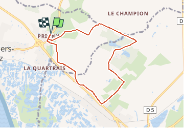
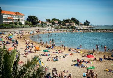
Tour Wandern von 7,8 km verfügbar auf Pays de la Loire, Loire-Atlantique, Les Moutiers-en-Retz. Diese Tour wird von neoroll44 vorgeschlagen.
Beschreibung
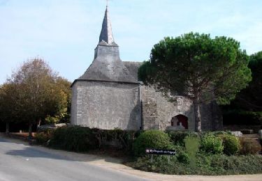
Balade facile de la chapelle de Prigny au camping de la Guerivière.
Départ du parking 150 m au nord de la chapelle (toilettes).
Ort
Land:
France
Region :
Pays de la Loire
Abteilung/Provinz :
Loire-Atlantique
Kommune :
Les Moutiers-en-Retz
Standort:
Unknown
Gehen Sie:(Dec)
Gehen Sie:(UTM)
577427 ; 5213138 (30T) N.
Kommentare
Touren in der Umgebung
![Tour Zu Fuß Villeneuve-en-Retz - PDIPR:1224 - Photo](https://media.geolcdn.com/t/375/260/1a57d417-9132-4bf4-870f-21ad0636d79e.jpeg&format=jpg&maxdim=2)
![Zu Fuß Zu Fuß](https://static1.geolcdn.com/sitytour/trail-icons/100.png)
PDIPR:1224
Zu Fuß
Einfach
Villeneuve-en-Retz,
Pays de la Loire,
Loire-Atlantique,
France
![](/images/other/stat-length.png)
16,4 km | 17,8 km-effort
4h 2min
![](https://static1.geolcdn.com/siteimages/upload/files/16400158638029165_repeat_loop_refresh_sync_direction_icon.png)
Nein
![Tour Zu Fuß Les Moutiers-en-Retz - Le Collet - Photo](https://media.geolcdn.com/t/375/260/1a57d417-9132-4bf4-870f-21ad0636d79e.jpeg&format=jpg&maxdim=2)
![Zu Fuß Zu Fuß](https://static1.geolcdn.com/sitytour/trail-icons/100.png)
Le Collet
Zu Fuß
Einfach
Les Moutiers-en-Retz,
Pays de la Loire,
Loire-Atlantique,
France
![](/images/other/stat-length.png)
9,9 km | 10,5 km-effort
2h 22min
![](https://static1.geolcdn.com/siteimages/upload/files/16400158638029165_repeat_loop_refresh_sync_direction_icon.png)
Ja
![Tour Wandern La Bernerie-en-Retz - Bernerie_Trou de l'enfer - Photo](https://media.geolcdn.com/t/375/260/ext.jpg?maxdim=2&url=https%3A%2F%2Fstatic1.geolcdn.com%2Fsiteimages%2Fupload%2Ffiles%2F1553511878bg_sport_marche.png)
![Wandern Wandern](https://static1.geolcdn.com/sitytour/trail-icons/101.png)
Bernerie_Trou de l'enfer
Wandern
Einfach
(1)
La Bernerie-en-Retz,
Pays de la Loire,
Loire-Atlantique,
France
![](/images/other/stat-length.png)
8,4 km | 9,5 km-effort
2h 10min
![](https://static1.geolcdn.com/siteimages/upload/files/16400158638029165_repeat_loop_refresh_sync_direction_icon.png)
Ja
![Tour Wandern Villeneuve-en-Retz - Bourgneuf - Photo](https://media.geolcdn.com/t/375/260/ext.jpg?maxdim=2&url=https%3A%2F%2Fservices.sitytrail.com%2FGeolivesWS%2FDownloadMedia.ashx%3FTrailID%3D242333%26Media%3D004523e4-4d0d-4608-bfa3-e711e62ed1cc.jpg)
![Wandern Wandern](https://static1.geolcdn.com/sitytour/trail-icons/101.png)
Bourgneuf
Wandern
Medium
Villeneuve-en-Retz,
Pays de la Loire,
Loire-Atlantique,
France
![](/images/other/stat-length.png)
14,4 km | 15,5 km-effort
3h 20min
![](https://static1.geolcdn.com/siteimages/upload/files/16400158638029165_repeat_loop_refresh_sync_direction_icon.png)
Ja
![Tour Wandern La Bernerie-en-Retz - La BERNERIE en RETZ - Photo](https://media.geolcdn.com/t/375/260/54207d45-9ea7-4a75-9cd9-948582a4f765.jpg&format=jpg&maxdim=2)
![Wandern Wandern](https://static1.geolcdn.com/sitytour/trail-icons/101.png)
La BERNERIE en RETZ
Wandern
Einfach
La Bernerie-en-Retz,
Pays de la Loire,
Loire-Atlantique,
France
![](/images/other/stat-length.png)
9,3 km | 10,7 km-effort
2h 24min
![](https://static1.geolcdn.com/siteimages/upload/files/16400158638029165_repeat_loop_refresh_sync_direction_icon.png)
Ja
![Tour Rennrad Les Moutiers-en-Retz - 2023-06-25 port du collet -port des champs - port du bec A.R - Photo](https://media.geolcdn.com/t/375/260/239f987b-fb5d-4c97-a07a-46e1d6ee0353.jpg&format=jpg&maxdim=2)
![Rennrad Rennrad](https://static1.geolcdn.com/sitytour/trail-icons/201.png)
2023-06-25 port du collet -port des champs - port du bec A.R
Rennrad
Medium
Les Moutiers-en-Retz,
Pays de la Loire,
Loire-Atlantique,
France
![](/images/other/stat-length.png)
37 km | 39 km-effort
2h 52min
![](https://static1.geolcdn.com/siteimages/upload/files/16400158638029165_repeat_loop_refresh_sync_direction_icon.png)
Ja
![Tour Wandern Villeneuve-en-Retz - 2023-05-14 circuit des migrateurs - Bourgneuf en Retz - Villeneuve en Retz - Photo](https://media.geolcdn.com/t/375/260/1be5e16d-e40a-4440-a96a-f4180087ba32.jpg&format=jpg&maxdim=2)
![Wandern Wandern](https://static1.geolcdn.com/sitytour/trail-icons/101.png)
2023-05-14 circuit des migrateurs - Bourgneuf en Retz - Villeneuve en Retz
Wandern
Einfach
Villeneuve-en-Retz,
Pays de la Loire,
Loire-Atlantique,
France
![](/images/other/stat-length.png)
10,5 km | 11 km-effort
2h 23min
![](https://static1.geolcdn.com/siteimages/upload/files/16400158638029165_repeat_loop_refresh_sync_direction_icon.png)
Ja
![Tour Wandern Villeneuve-en-Retz - Bourgneuf - Pornic - Photo](https://media.geolcdn.com/t/375/260/990b9ccf-eba1-4846-b79b-2e31a5fdc003.jpg&format=jpg&maxdim=2)
![Wandern Wandern](https://static1.geolcdn.com/sitytour/trail-icons/101.png)
Bourgneuf - Pornic
Wandern
Medium
Villeneuve-en-Retz,
Pays de la Loire,
Loire-Atlantique,
France
![](/images/other/stat-length.png)
21 km | 23 km-effort
4h 15min
![](https://static1.geolcdn.com/siteimages/upload/files/16400158638029165_repeat_loop_refresh_sync_direction_icon.png)
Nein
![Tour Wandern La Bernerie-en-Retz - La Bernerie _ Tréans - Photo](https://media.geolcdn.com/t/375/260/237fba22-9579-41b1-b654-509627a6628f.jpg&format=jpg&maxdim=2)
![Wandern Wandern](https://static1.geolcdn.com/sitytour/trail-icons/101.png)
La Bernerie _ Tréans
Wandern
Einfach
La Bernerie-en-Retz,
Pays de la Loire,
Loire-Atlantique,
France
![](/images/other/stat-length.png)
9,9 km | 10,7 km-effort
2h 30min
![](https://static1.geolcdn.com/siteimages/upload/files/16400158638029165_repeat_loop_refresh_sync_direction_icon.png)
Ja