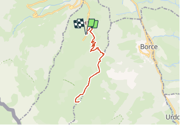
![](/images/other/stat-length.png)
![Tour Wandern Accous - pic labigouer 2175m - Photo](https://media.geolcdn.com/t/1900/400/ec4caccd-66da-42df-9285-f84ea2cc27b7.jpg&format=pjpeg&maxdim=2)
pic labigouer 2175m
neoroll44
Benutzer
![Länge](/images/other/stat-length.png)
![Maximale Höhe](https://static1.geolcdn.com/siteimages/upload/files/1508320355ic_sort_altitude_max_24dp.png)
![Positive Höhendifferenz](https://static1.geolcdn.com/siteimages/upload/files/1508320355ic_sort_den_pos_24dp.png)
![Km-Effort](/images/other/stat-length.png)
![Min. Höhe](https://static1.geolcdn.com/siteimages/upload/files/1508320355ic_sort_altitude_min_24dp.png)
![Negative Höhendifferenz](https://static1.geolcdn.com/siteimages/upload/files/1508320355ic_sort_den_neg_24dp.png)
![Boucle](https://static1.geolcdn.com/siteimages/upload/files/16400158638029165_repeat_loop_refresh_sync_direction_icon.png)
![Wandern](https://static1.geolcdn.com/sitytour/trail-icons/101.png)
7h30
Schwierigkeit : Schwierig
![Scannen Sie diesen QR-Code, um die Tour in der SityTrail-Anwendung zu öffnen](https://capi.geolives.com/qq0zvz2zws4bq2lad0pu/sitytour/trails/2719869/qr.png?size=200)
Kostenlosegpshiking-Anwendung
Über SityTrail
Tour Wandern von 16,7 km verfügbar auf Neu-Aquitanien, Pyrenäen-Atlantik, Accous. Diese Tour wird von neoroll44 vorgeschlagen.
Beschreibung
Quitter la N134 (route de somport) six km au sud de Bédous pour franchir le pont de Lescun (487m), et monter au sud-ouest la D239 (route de Lescun), prendre la direction de Lhers, 800m après Lhers arrêtez-vous à l’embranchement de la route forestière du Tuquet, (500m avant le gite d’étape).
Difficultés: Aucune par temps clair et en l’absence de neige.
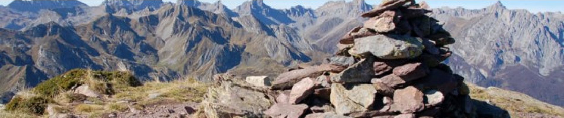
Le cirque de Lescun est séparé de la vallée d’Aspe par une crête que le GR10 franchit au col de Barrancq (1601m) avant de plonger sur Etsau, 1000m en contrebas… du col de Barrancq, il est facile de poursuivre la crête au sud-ouest, jusqu’au Pic de Labigouer 2175m, remarquable belvédère, avec possibilité de revenir en circuit par le col de souperret 1920m.
Malgré le balisage GR, la montée au col de Barrancq demande un peu de vigilance: les travaux forestiers peuvent modifier l’état des chemins et faire sauter des balises, d’autre part, des marques rouges sur fond blanc peuvent préter à confusion avec la signalisation du GR.
Ort
Kommentare
Touren in der Umgebung
![Tour Schneeschuhwandern Borce - Refuge et lac d’Arlet - Photo](https://media.geolcdn.com/t/375/260/a5cc868f-a627-4b9d-939f-bef0d8443aec.jpg&format=jpg&maxdim=2)
![Schneeschuhwandern Schneeschuhwandern](https://static1.geolcdn.com/sitytour/trail-icons/504.png)
Schneeschuhwandern
![](/images/other/stat-length.png)
![](https://static1.geolcdn.com/siteimages/upload/files/16400158638029165_repeat_loop_refresh_sync_direction_icon.png)
![Tour Wandern Etsaut - CHEMIN DE LA MATURE - Photo](https://media.geolcdn.com/t/375/260/ext.jpg?maxdim=2&url=https%3A%2F%2Fservices.sitytrail.com%2FGeolivesWS%2FDownloadMedia.ashx%3FTrailID%3D330343%26Media%3Dfix__20140727111121.jpg)
![Wandern Wandern](https://static1.geolcdn.com/sitytour/trail-icons/101.png)
Wandern
![](/images/other/stat-length.png)
![](https://static1.geolcdn.com/siteimages/upload/files/16400158638029165_repeat_loop_refresh_sync_direction_icon.png)
![Tour Wandern Lescun - Le plateau de Sanchèse - Lescun - Photo](https://media.geolcdn.com/t/375/260/ext.jpg?maxdim=2&url=https%3A%2F%2Fservices.sitytrail.com%2FGeolivesWS%2FDownloadMedia.ashx%3FTrailID%3D111284%26Media%3D6928_1.jpg)
![Wandern Wandern](https://static1.geolcdn.com/sitytour/trail-icons/101.png)
Wandern
![](/images/other/stat-length.png)
![](https://static1.geolcdn.com/siteimages/upload/files/16400158638029165_repeat_loop_refresh_sync_direction_icon.png)
![Tour Wandern Etsaut - Chemin de la Mâture en vallée d'Aspe - Photo](https://media.geolcdn.com/t/375/260/ext.jpg?maxdim=2&url=https%3A%2F%2Fservices.sitytrail.com%2FGeolivesWS%2FDownloadMedia.ashx%3FTrailID%3D109346%26Media%3D3629_1.jpg)
![Wandern Wandern](https://static1.geolcdn.com/sitytour/trail-icons/101.png)
Wandern
![](/images/other/stat-length.png)
![](https://static1.geolcdn.com/siteimages/upload/files/16400158638029165_repeat_loop_refresh_sync_direction_icon.png)
![Tour Wandern Lescun - Lac de Lhurs - Photo](https://media.geolcdn.com/t/375/260/ext.jpg?maxdim=2&url=https%3A%2F%2Fservices.sitytrail.com%2FGeolivesWS%2FDownloadMedia.ashx%3FTrailID%3D106243%26Media%3D10574_1.jpg)
![Wandern Wandern](https://static1.geolcdn.com/sitytour/trail-icons/101.png)
Wandern
![](/images/other/stat-length.png)
![](https://static1.geolcdn.com/siteimages/upload/files/16400158638029165_repeat_loop_refresh_sync_direction_icon.png)
![Tour Zu Fuß Cette-Eygun - Granges de Cette asp56 - Photo](https://media.geolcdn.com/t/375/260/45ec37bb-ebfa-4fac-a648-b2e50bb11731.jpeg&format=jpg&maxdim=2)
![Zu Fuß Zu Fuß](https://static1.geolcdn.com/sitytour/trail-icons/100.png)
Zu Fuß
![](/images/other/stat-length.png)
![](https://static1.geolcdn.com/siteimages/upload/files/16400158638029165_repeat_loop_refresh_sync_direction_icon.png)
![Tour Zu Fuß Cette-Eygun - Cabane de Lhèze asp116 - Photo](https://media.geolcdn.com/t/375/260/45ec37bb-ebfa-4fac-a648-b2e50bb11731.jpeg&format=jpg&maxdim=2)
![Zu Fuß Zu Fuß](https://static1.geolcdn.com/sitytour/trail-icons/100.png)
Zu Fuß
![](/images/other/stat-length.png)
![](https://static1.geolcdn.com/siteimages/upload/files/16400158638029165_repeat_loop_refresh_sync_direction_icon.png)
![Tour Zu Fuß Cette-Eygun - Cabanes de Narbèze asp117 - Photo](https://media.geolcdn.com/t/375/260/45ec37bb-ebfa-4fac-a648-b2e50bb11731.jpeg&format=jpg&maxdim=2)
![Zu Fuß Zu Fuß](https://static1.geolcdn.com/sitytour/trail-icons/100.png)
Zu Fuß
![](/images/other/stat-length.png)
![](https://static1.geolcdn.com/siteimages/upload/files/16400158638029165_repeat_loop_refresh_sync_direction_icon.png)
![Tour Zu Fuß Cette-Eygun - Tour de Lasies asp115 - Photo](https://media.geolcdn.com/t/375/260/c7bf7b32-3f7c-4bff-b706-8b021e3df474.jpeg&format=jpg&maxdim=2)
![Zu Fuß Zu Fuß](https://static1.geolcdn.com/sitytour/trail-icons/100.png)
Zu Fuß
![](/images/other/stat-length.png)
![](https://static1.geolcdn.com/siteimages/upload/files/16400158638029165_repeat_loop_refresh_sync_direction_icon.png)