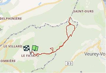
![](/images/other/stat-length.png)
![Tour Wandern Montaud - La dent de Moirans - Photo](https://media.geolcdn.com/t/1900/400/c31d5ba7-98c1-4d2c-8f51-1281362b0eb5.jpg&format=pjpeg&maxdim=2)
La dent de Moirans
crocau
Benutzer
![Länge](/images/other/stat-length.png)
![Maximale Höhe](https://static1.geolcdn.com/siteimages/upload/files/1508320355ic_sort_altitude_max_24dp.png)
![Positive Höhendifferenz](https://static1.geolcdn.com/siteimages/upload/files/1508320355ic_sort_den_pos_24dp.png)
![Km-Effort](/images/other/stat-length.png)
![Min. Höhe](https://static1.geolcdn.com/siteimages/upload/files/1508320355ic_sort_altitude_min_24dp.png)
![Negative Höhendifferenz](https://static1.geolcdn.com/siteimages/upload/files/1508320355ic_sort_den_neg_24dp.png)
![Boucle](https://static1.geolcdn.com/siteimages/upload/files/16400158638029165_repeat_loop_refresh_sync_direction_icon.png)
![Wandern](https://static1.geolcdn.com/sitytour/trail-icons/101.png)
2h57
Schwierigkeit : Sehr leicht
![Scannen Sie diesen QR-Code, um die Tour in der SityTrail-Anwendung zu öffnen](https://capi.geolives.com/qq0zvz2zws4bq2lad0pu/sitytour/trails/2715958/qr.png?size=200)
Kostenlosegpshiking-Anwendung
Über SityTrail
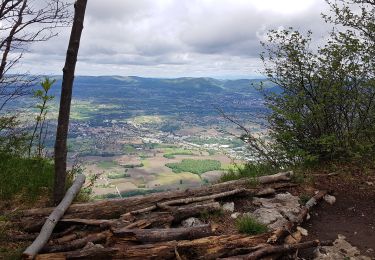
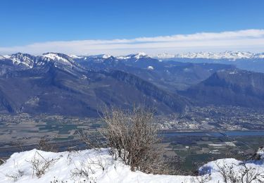
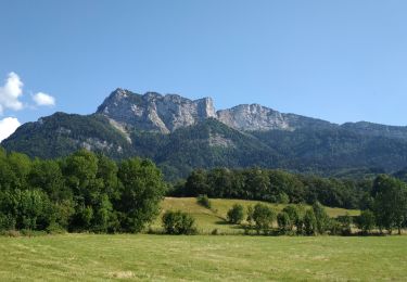
Tour Wandern von 8,9 km verfügbar auf Auvergne-Rhone-Alpen, Isère, Montaud. Diese Tour wird von crocau vorgeschlagen.
Beschreibung
Nous avons fait le parcours indiqué par Eric Merlen ( 52 balades autour de Grenoble, éditions Didier Guichard) .
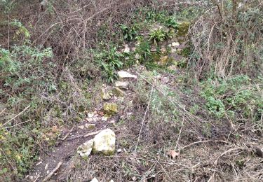
On trouve facilement le point de départ, le tracé est bien fait . ATTENTION la boucle de retour entre la dent elle même et le chemin aller n'est qu'une trace noire sur le GPS ..et vous ne trouverez aucune trace sur les arbres mais un sentier visible. Par contre beaucoup de traces d'animaux y compris celle d'un loup.
Ort
Kommentare
Touren in der Umgebung
![Tour Wandern Voreppe - 38 voreppe - Photo](https://media.geolcdn.com/t/375/260/ae534631-eaae-45ff-8bde-8ca8e28aadbe.jpg&format=jpg&maxdim=2)
![Wandern Wandern](https://static1.geolcdn.com/sitytour/trail-icons/101.png)
Wandern
![](/images/other/stat-length.png)
![](https://static1.geolcdn.com/siteimages/upload/files/16400158638029165_repeat_loop_refresh_sync_direction_icon.png)
![Tour Wandern Saint-Quentin-sur-Isère - 38 St Quentin sur isere - Photo](https://media.geolcdn.com/t/375/260/a8213203-4838-4b30-a9a1-6f63f9fa0c7f.jpg&format=jpg&maxdim=2)
![Wandern Wandern](https://static1.geolcdn.com/sitytour/trail-icons/101.png)
Wandern
![](/images/other/stat-length.png)
![](https://static1.geolcdn.com/siteimages/upload/files/16400158638029165_repeat_loop_refresh_sync_direction_icon.png)
![Tour Elektrofahrrad Voreppe - voreppe saint julien le grand raz voreppe - Photo](https://media.geolcdn.com/t/375/260/ext.jpg?maxdim=2&url=https%3A%2F%2Fstatic1.geolcdn.com%2Fsiteimages%2Fupload%2Ffiles%2F1524743154velo.jpg)
![Elektrofahrrad Elektrofahrrad](https://static1.geolcdn.com/sitytour/trail-icons/205.png)
Elektrofahrrad
![](/images/other/stat-length.png)
![](https://static1.geolcdn.com/siteimages/upload/files/16400158638029165_repeat_loop_refresh_sync_direction_icon.png)
![Tour Wandern Voreppe - le trou au loup - Photo](https://media.geolcdn.com/t/375/260/4be90cdf-26f4-4d2a-b22f-02f0baa87490.jpg&format=jpg&maxdim=2)
![Wandern Wandern](https://static1.geolcdn.com/sitytour/trail-icons/101.png)
Wandern
![](/images/other/stat-length.png)
![](https://static1.geolcdn.com/siteimages/upload/files/16400158638029165_repeat_loop_refresh_sync_direction_icon.png)
![Tour Wandern Saint-Quentin-sur-Isère - Dent de Moirans - Photo](https://media.geolcdn.com/t/375/260/cc5b3296-26ad-4d08-b80e-e1eedf7283f6.jpg&format=jpg&maxdim=2)
![Wandern Wandern](https://static1.geolcdn.com/sitytour/trail-icons/101.png)
Wandern
![](/images/other/stat-length.png)
![](https://static1.geolcdn.com/siteimages/upload/files/16400158638029165_repeat_loop_refresh_sync_direction_icon.png)
![Tour Wandern Saint-Quentin-sur-Isère - 38 carrières echaillon - Photo](https://media.geolcdn.com/t/375/260/728d4589-2ee2-49ea-a83d-3257b1bf0904.jpg&format=jpg&maxdim=2)
![Wandern Wandern](https://static1.geolcdn.com/sitytour/trail-icons/101.png)
Wandern
![](/images/other/stat-length.png)
![](https://static1.geolcdn.com/siteimages/upload/files/16400158638029165_repeat_loop_refresh_sync_direction_icon.png)
![Tour Wandern Montaud - La Dent de Moirans - Photo](https://media.geolcdn.com/t/375/260/42159542-0525-485e-906a-e99c0c2c152d.jpg&format=jpg&maxdim=2)
![Wandern Wandern](https://static1.geolcdn.com/sitytour/trail-icons/101.png)
Wandern
![](/images/other/stat-length.png)
![](https://static1.geolcdn.com/siteimages/upload/files/16400158638029165_repeat_loop_refresh_sync_direction_icon.png)
![Tour Wandern Autrans-Méaudre en Vercors - boucle la Buffe - la Sure - Photo](https://media.geolcdn.com/t/375/260/9d650f75-523f-40ee-a83c-0bfaf17ae3cc.jpg&format=jpg&maxdim=2)
![Wandern Wandern](https://static1.geolcdn.com/sitytour/trail-icons/101.png)
Wandern
![](/images/other/stat-length.png)
![](https://static1.geolcdn.com/siteimages/upload/files/16400158638029165_repeat_loop_refresh_sync_direction_icon.png)
![Tour Wandern Montaud - BOUCLE MONTAUD DE T DE MOIRANS - Photo](https://media.geolcdn.com/t/375/260/e130ea2b-4587-4c00-ae7c-a57eb66385d6.jpg&format=jpg&maxdim=2)
![Wandern Wandern](https://static1.geolcdn.com/sitytour/trail-icons/101.png)
Wandern
![](/images/other/stat-length.png)
![](https://static1.geolcdn.com/siteimages/upload/files/16400158638029165_repeat_loop_refresh_sync_direction_icon.png)