![](/images/other/stat-length.png)
![Tour Wandern Aix-les-Bains - MONT DE CORSUET: FORET DE CORSUET - GROTTE DES FEES - Photo](https://media.geolcdn.com/t/1900/400/1a223c80-4114-47f3-bd56-ce772312e154.jpg&format=pjpeg&maxdim=2)
MONT DE CORSUET: FORET DE CORSUET - GROTTE DES FEES
djeepee74
Benutzer
![Länge](/images/other/stat-length.png)
![Maximale Höhe](https://static1.geolcdn.com/siteimages/upload/files/1508320355ic_sort_altitude_max_24dp.png)
![Positive Höhendifferenz](https://static1.geolcdn.com/siteimages/upload/files/1508320355ic_sort_den_pos_24dp.png)
![Km-Effort](/images/other/stat-length.png)
![Min. Höhe](https://static1.geolcdn.com/siteimages/upload/files/1508320355ic_sort_altitude_min_24dp.png)
![Negative Höhendifferenz](https://static1.geolcdn.com/siteimages/upload/files/1508320355ic_sort_den_neg_24dp.png)
![Boucle](https://static1.geolcdn.com/siteimages/upload/files/16400158638029165_repeat_loop_refresh_sync_direction_icon.png)
![Wandern](https://static1.geolcdn.com/sitytour/trail-icons/101.png)
3h15
Schwierigkeit : Einfach
![Scannen Sie diesen QR-Code, um die Tour in der SityTrail-Anwendung zu öffnen](https://capi.geolives.com/qq0zvz2zws4bq2lad0pu/sitytour/trails/2711757/qr.png?size=200)
Kostenlosegpshiking-Anwendung
Über SityTrail
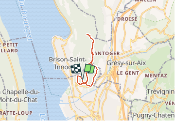
Tour Wandern von 9,1 km verfügbar auf Auvergne-Rhone-Alpen, Savoyen, Aix-les-Bains. Diese Tour wird von djeepee74 vorgeschlagen.
Beschreibung
BOUCLE... live 20210318
Départ parking central (45.713184 ; 5.900838).
Au retour (km 4.9), pour éviter le sentier des crêtes glissant, ne pas remonter les "escaliers" mais prendre à gauche, juste avant, le chemin de chez Raymond... pour le quitter, aussitôt, par une grosse ornière et plonger dans le pré sur la droite.
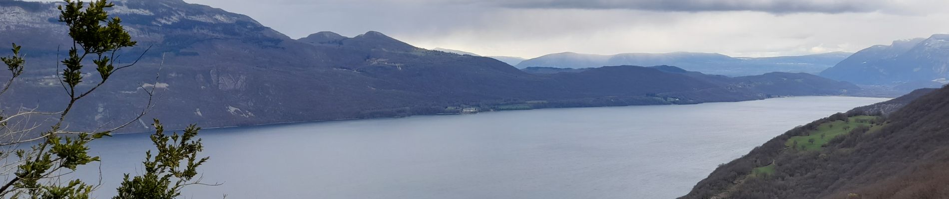
Le belvédère de Corsuet (Km 6) donne une vue sur le Revard... l'été, avec les feuilles, on ne doit pas voir grand chose !
La partie finale (boucle bitumée) avant de retrouver le parking) n'a pas grand intérêt.
Ort
Kommentare
Touren in der Umgebung
![Tour Wandern Brison-Saint-Innocent - La Croix de Meyrieu, retour par la Grotte des Fées, depuis les Combes - Photo](https://media.geolcdn.com/t/375/260/ext.jpg?maxdim=2&url=https%3A%2F%2Fservices.sitytrail.com%2FGeolivesWS%2FDownloadMedia.ashx%3FTrailID%3D317495%26Media%3D16730_1.jpg)
![Wandern Wandern](https://static1.geolcdn.com/sitytour/trail-icons/101.png)
Wandern
![](/images/other/stat-length.png)
![](https://static1.geolcdn.com/siteimages/upload/files/16400158638029165_repeat_loop_refresh_sync_direction_icon.png)
![Tour Mountainbike Aix-les-Bains - Randolac 2008 - Epine Chat Chambotte - Photo](https://media.geolcdn.com/t/375/260/ext.jpg?maxdim=2&url=https%3A%2F%2Fservices.sitytrail.com%2FGeolivesWS%2FDownloadMedia.ashx%3FTrailID%3D102831%26Media%3D3994_2.jpg)
![Mountainbike Mountainbike](https://static1.geolcdn.com/sitytour/trail-icons/202.png)
Mountainbike
![](/images/other/stat-length.png)
![](https://static1.geolcdn.com/siteimages/upload/files/16400158638029165_repeat_loop_refresh_sync_direction_icon.png)
![Tour Wandern Brison-Saint-Innocent - Grotte des fées, Croix de Meyrieu, Mont Corsuet 843m 1.7.24 - Photo](https://media.geolcdn.com/t/375/260/40c03b1e-7ecc-48c9-b0a4-5c8c250e48e1.jpg&format=jpg&maxdim=2)
![Wandern Wandern](https://static1.geolcdn.com/sitytour/trail-icons/101.png)
Wandern
![](/images/other/stat-length.png)
![](https://static1.geolcdn.com/siteimages/upload/files/16400158638029165_repeat_loop_refresh_sync_direction_icon.png)
![Tour Elektrofahrrad Aix-les-Bains - Aix les bains tour lac de Bourget abbaye Hautecombes - Photo](https://media.geolcdn.com/t/375/260/6de4fae3-0815-4d48-bb94-d895cfa7b1bb.jpg&format=jpg&maxdim=2)
![Elektrofahrrad Elektrofahrrad](https://static1.geolcdn.com/sitytour/trail-icons/205.png)
Elektrofahrrad
![](/images/other/stat-length.png)
![](https://static1.geolcdn.com/siteimages/upload/files/16400158638029165_repeat_loop_refresh_sync_direction_icon.png)
![Tour Wandern Mouxy - Sentier du Perthuiset - Photo](https://media.geolcdn.com/t/375/260/ext.jpg?maxdim=2&url=https%3A%2F%2Fstatic1.geolcdn.com%2Fsiteimages%2Fupload%2Ffiles%2F1553511878bg_sport_marche.png)
![Wandern Wandern](https://static1.geolcdn.com/sitytour/trail-icons/101.png)
Wandern
![](/images/other/stat-length.png)
![](https://static1.geolcdn.com/siteimages/upload/files/16400158638029165_repeat_loop_refresh_sync_direction_icon.png)
![Tour Wandern Saint-Jean-de-Chevelu - La dent du chat - Photo](https://media.geolcdn.com/t/375/260/ext.jpg?maxdim=2&url=https%3A%2F%2Fstatic1.geolcdn.com%2Fsiteimages%2Fupload%2Ffiles%2F1553511878bg_sport_marche.png)
![Wandern Wandern](https://static1.geolcdn.com/sitytour/trail-icons/101.png)
Wandern
![](/images/other/stat-length.png)
![](https://static1.geolcdn.com/siteimages/upload/files/16400158638029165_repeat_loop_refresh_sync_direction_icon.png)
![Tour Klettersteig La Chapelle-du-Mont-du-Chat - 2011-04-03 via ferrata Col du chat - Photo](https://media.geolcdn.com/t/375/260/ext.jpg?maxdim=2&url=https%3A%2F%2Fstatic1.geolcdn.com%2Fsiteimages%2Fupload%2Ffiles%2F1545311037marcheuse_200dpi.jpg)
![Klettersteig Klettersteig](https://static1.geolcdn.com/sitytour/trail-icons/902.png)
Klettersteig
![](/images/other/stat-length.png)
![](https://static1.geolcdn.com/siteimages/upload/files/16400158638029165_repeat_loop_refresh_sync_direction_icon.png)
![Tour sport Aix-les-Bains - Colline du poète - Photo](https://media.geolcdn.com/t/375/260/52193566-3029-4655-87e0-73eaaebe11d3.jpg&format=jpg&maxdim=2)
sport
![](/images/other/stat-length.png)
![](https://static1.geolcdn.com/siteimages/upload/files/16400158638029165_repeat_loop_refresh_sync_direction_icon.png)
![Tour Wandern La Chapelle-du-Mont-du-Chat - 270523 Tour et Dent du Chat - Photo](https://media.geolcdn.com/t/375/260/0a1b231b-4827-4287-a183-6427b560c2c1.jpg&format=jpg&maxdim=2)
![Wandern Wandern](https://static1.geolcdn.com/sitytour/trail-icons/101.png)
Wandern
![](/images/other/stat-length.png)
![](https://static1.geolcdn.com/siteimages/upload/files/16400158638029165_repeat_loop_refresh_sync_direction_icon.png)