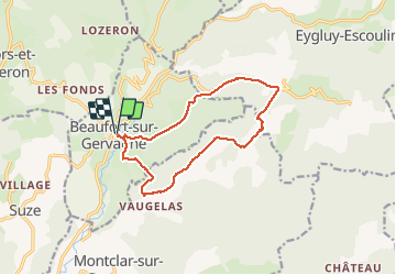
![](/images/other/stat-length.png)
![Tour Wandern Beaufort-sur-Gervanne - Beaufort sur gervanne - Photo](https://media.geolcdn.com/t/1900/400/168346e1-28da-47c8-828b-b860d95a2e5d.jpg&format=pjpeg&maxdim=2)
Beaufort sur gervanne
AIGUIER
Benutzer
![Länge](/images/other/stat-length.png)
![Maximale Höhe](https://static1.geolcdn.com/siteimages/upload/files/1508320355ic_sort_altitude_max_24dp.png)
![Positive Höhendifferenz](https://static1.geolcdn.com/siteimages/upload/files/1508320355ic_sort_den_pos_24dp.png)
![Km-Effort](/images/other/stat-length.png)
![Min. Höhe](https://static1.geolcdn.com/siteimages/upload/files/1508320355ic_sort_altitude_min_24dp.png)
![Negative Höhendifferenz](https://static1.geolcdn.com/siteimages/upload/files/1508320355ic_sort_den_neg_24dp.png)
![Boucle](https://static1.geolcdn.com/siteimages/upload/files/16400158638029165_repeat_loop_refresh_sync_direction_icon.png)
![Wandern](https://static1.geolcdn.com/sitytour/trail-icons/101.png)
4h40
Schwierigkeit : Medium
![Scannen Sie diesen QR-Code, um die Tour in der SityTrail-Anwendung zu öffnen](https://capi.geolives.com/qq0zvz2zws4bq2lad0pu/sitytour/trails/2704040/qr.png?size=200)
Kostenlosegpshiking-Anwendung
Über SityTrail
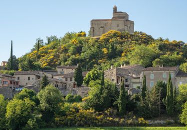
Tour Wandern von 13,4 km verfügbar auf Auvergne-Rhone-Alpen, Drôme, Beaufort-sur-Gervanne. Diese Tour wird von AIGUIER vorgeschlagen.
Beschreibung
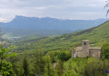
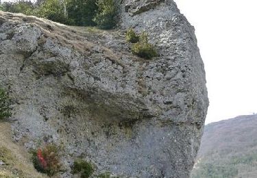
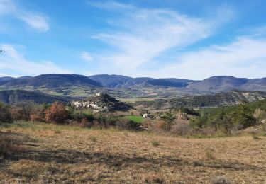
Belle randonnée, avec de magnifiques sentiers boisés ; Un bon groupe (15) décidé à se défouler dans cette belle nature. Regard sur la somptueuse Falaise de Plan de Baix. Un bon champ pour notre casse croûte. Vue sur le Massif de la Forêt de Saou. Grande piste forestière pour le retour. Magnifique rivière de La Gervanne et son village de Beaufort.
Ort
Kommentare
Touren in der Umgebung
![Tour Wandern Gigors-et-Lozeron - Gigors - Saint-Supière - Photo](https://media.geolcdn.com/t/375/260/7a89f170-854d-4e76-988d-32a2f6e427fd.jpg&format=jpg&maxdim=2)
![Wandern Wandern](https://static1.geolcdn.com/sitytour/trail-icons/101.png)
Wandern
![](/images/other/stat-length.png)
![](https://static1.geolcdn.com/siteimages/upload/files/16400158638029165_repeat_loop_refresh_sync_direction_icon.png)
![Tour Wandern Gigors-et-Lozeron - St Supière et Savel à Gigors et Lozeron - Photo](https://media.geolcdn.com/t/375/260/ext.jpg?maxdim=2&url=https%3A%2F%2Fservices.sitytrail.com%2FGeolivesWS%2FDownloadMedia.ashx%3FTrailID%3D103208%26Media%3D5080_3.jpg)
![Wandern Wandern](https://static1.geolcdn.com/sitytour/trail-icons/101.png)
Wandern
![](/images/other/stat-length.png)
![](https://static1.geolcdn.com/siteimages/upload/files/16400158638029165_repeat_loop_refresh_sync_direction_icon.png)
![Tour Wandern Montclar-sur-Gervanne - Montclar sur Gervanne-Col Gerbe-Chple St Christophe 17km - Photo](https://media.geolcdn.com/t/375/260/1c8b8899-04e8-4a27-b14a-14d516682923.jpg&format=jpg&maxdim=2)
![Wandern Wandern](https://static1.geolcdn.com/sitytour/trail-icons/101.png)
Wandern
![](/images/other/stat-length.png)
![](https://static1.geolcdn.com/siteimages/upload/files/16400158638029165_repeat_loop_refresh_sync_direction_icon.png)
![Tour Wandern Montclar-sur-Gervanne - 2023-02-26_18h25m27_Montclar sur Gervanne 16km - Photo](https://media.geolcdn.com/t/375/260/ebf5c7b8-3682-4aaf-a165-5eb68ffb7b11.jpg&format=jpg&maxdim=2)
![Wandern Wandern](https://static1.geolcdn.com/sitytour/trail-icons/101.png)
Wandern
![](/images/other/stat-length.png)
![](https://static1.geolcdn.com/siteimages/upload/files/16400158638029165_repeat_loop_refresh_sync_direction_icon.png)
![Tour Wandern Beaufort-sur-Gervanne - 26 gervanne druise plan de baix - Photo](https://media.geolcdn.com/t/375/260/cef04867-033e-4aa7-8c70-c5079a2317fe.jpg&format=jpg&maxdim=2)
![Wandern Wandern](https://static1.geolcdn.com/sitytour/trail-icons/101.png)
Wandern
![](/images/other/stat-length.png)
![](https://static1.geolcdn.com/siteimages/upload/files/16400158638029165_repeat_loop_refresh_sync_direction_icon.png)
![Tour Wandern Beaufort-sur-Gervanne - Beaufort St Pancrace 17km - Photo](https://media.geolcdn.com/t/375/260/ext.jpg?maxdim=2&url=https%3A%2F%2Fstatic1.geolcdn.com%2Fsiteimages%2Fupload%2Ffiles%2F1553511878bg_sport_marche.png)
![Wandern Wandern](https://static1.geolcdn.com/sitytour/trail-icons/101.png)
Wandern
![](/images/other/stat-length.png)
![](https://static1.geolcdn.com/siteimages/upload/files/16400158638029165_repeat_loop_refresh_sync_direction_icon.png)
![Tour Wandern Gigors-et-Lozeron - 26 st supporte gigors - Photo](https://media.geolcdn.com/t/375/260/c169c5cd-1ed9-4b41-908c-c962ab944e47.jpg&format=jpg&maxdim=2)
![Wandern Wandern](https://static1.geolcdn.com/sitytour/trail-icons/101.png)
Wandern
![](/images/other/stat-length.png)
![](https://static1.geolcdn.com/siteimages/upload/files/16400158638029165_repeat_loop_refresh_sync_direction_icon.png)
![Tour Wandern Gigors-et-Lozeron - 26 gigors zel 24.01.25 - Photo](https://media.geolcdn.com/t/375/260/6d773d26-45d9-491c-869c-836081a35829.jpg&format=jpg&maxdim=2)
![Wandern Wandern](https://static1.geolcdn.com/sitytour/trail-icons/101.png)
Wandern
![](/images/other/stat-length.png)
![](https://static1.geolcdn.com/siteimages/upload/files/16400158638029165_repeat_loop_refresh_sync_direction_icon.png)
![Tour Wandern Beaufort-sur-Gervanne - Beaufort - Gigors - Lozeron - Photo](https://media.geolcdn.com/t/375/260/8cacbdb2-dbdb-432d-83ba-9c60bb3f8279.jpg&format=jpg&maxdim=2)
![Wandern Wandern](https://static1.geolcdn.com/sitytour/trail-icons/101.png)
Wandern
![](/images/other/stat-length.png)
![](https://static1.geolcdn.com/siteimages/upload/files/16400158638029165_repeat_loop_refresh_sync_direction_icon.png)