![](/images/other/stat-length.png)
MAULEON-BAROUSSE la boucle des 2 ourses G3 2703781
marmotte65
Benutzer GUIDE
![Länge](/images/other/stat-length.png)
![Maximale Höhe](https://static1.geolcdn.com/siteimages/upload/files/1508320355ic_sort_altitude_max_24dp.png)
![Positive Höhendifferenz](https://static1.geolcdn.com/siteimages/upload/files/1508320355ic_sort_den_pos_24dp.png)
![Km-Effort](/images/other/stat-length.png)
![Min. Höhe](https://static1.geolcdn.com/siteimages/upload/files/1508320355ic_sort_altitude_min_24dp.png)
![Negative Höhendifferenz](https://static1.geolcdn.com/siteimages/upload/files/1508320355ic_sort_den_neg_24dp.png)
![Boucle](https://static1.geolcdn.com/siteimages/upload/files/16400158638029165_repeat_loop_refresh_sync_direction_icon.png)
![Wandern](https://static1.geolcdn.com/sitytour/trail-icons/101.png)
2h50
Schwierigkeit : Einfach
![Scannen Sie diesen QR-Code, um die Tour in der SityTrail-Anwendung zu öffnen](https://capi.geolives.com/qq0zvz2zws4bq2lad0pu/sitytour/trails/2703781/qr.png?size=200)
Kostenlosegpshiking-Anwendung
Über SityTrail
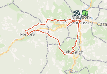
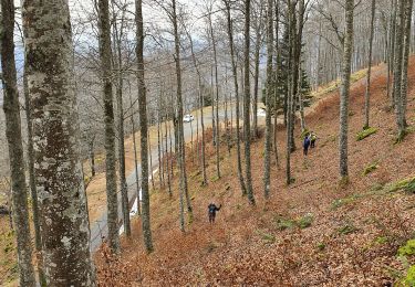
Tour Wandern von 9,5 km verfügbar auf Okzitanien, Hautes-Pyrénées, Mauléon-Barousse. Diese Tour wird von marmotte65 vorgeschlagen.
Beschreibung
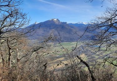
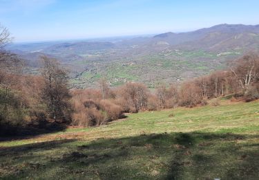
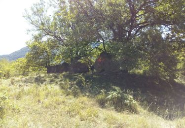
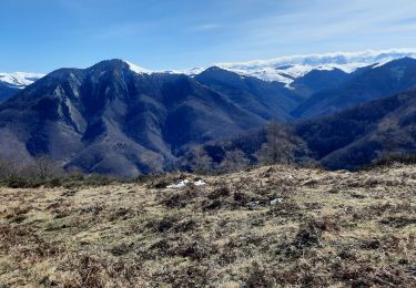
C'est une magnifique balade sans difficulté la traversée de ces villages de piemont qui sont Mauleon - Ferrere et Ourdé sont offre une délicieuse envie d'en faire le tour. Juste une precaution a prendre .
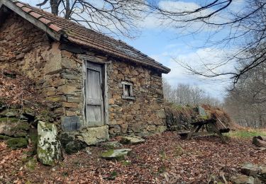
Dans Ferrere une maison est en train de s'effondrée elle est étayée mais il vaut mieux prendre un autre itinéraire dans Ferrere.
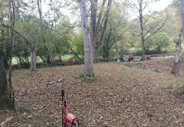
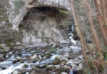
Le PN sera pris au niveau de la traversée a gué d'un petit ruisseau qui offre suffisemment de plats pour recevoir une quinzaine de personnes
Mais assez de bla bla allez-y .vous m'n direz des nouvelles.
Ort
Kommentare
Touren in der Umgebung
![Tour Wandern Antichan - sommet d'Herbe Rouge en boucle depuis Antichan - Photo](https://media.geolcdn.com/t/375/260/2676d141-2d54-4591-a0ca-fc3fcbbbc6ad.jpg&format=jpg&maxdim=2)
![Wandern Wandern](https://static1.geolcdn.com/sitytour/trail-icons/101.png)
Wandern
![](/images/other/stat-length.png)
![](https://static1.geolcdn.com/siteimages/upload/files/16400158638029165_repeat_loop_refresh_sync_direction_icon.png)
![Tour Wandern Mauléon-Barousse - MAULEON BAROUSSE la rando de Payremilla (G3) faite le 23/10/2020 - Photo](https://media.geolcdn.com/t/375/260/f54aedb7-7843-4cd9-8363-8502c158108a.jpg&format=jpg&maxdim=2)
![Wandern Wandern](https://static1.geolcdn.com/sitytour/trail-icons/101.png)
Wandern
![](/images/other/stat-length.png)
![](https://static1.geolcdn.com/siteimages/upload/files/16400158638029165_repeat_loop_refresh_sync_direction_icon.png)
![Tour Wandern Bramevaque - randonnée sur le Touroc depuis Bramevaque - Photo](https://media.geolcdn.com/t/375/260/11044ee2-ac3e-40d6-87ed-897d2a6f400f.jpg&format=jpg&maxdim=2)
![Wandern Wandern](https://static1.geolcdn.com/sitytour/trail-icons/101.png)
Wandern
![](/images/other/stat-length.png)
![](https://static1.geolcdn.com/siteimages/upload/files/16400158638029165_repeat_loop_refresh_sync_direction_icon.png)
![Tour Wandern Mauléon-Barousse - MAULEON BAROUSSE Circuit des amis du Lac](https://media.geolcdn.com/t/375/260/514ad499-f66e-4243-b144-7abeb20a1a25.jpg&format=jpg&maxdim=2)
![Wandern Wandern](https://static1.geolcdn.com/sitytour/trail-icons/101.png)
Wandern
![](/images/other/stat-length.png)
![](https://static1.geolcdn.com/siteimages/upload/files/16400158638029165_repeat_loop_refresh_sync_direction_icon.png)
![Tour Wandern Ferrère - pic de Douly en boucle depuis Ferrère - Photo](https://media.geolcdn.com/t/375/260/c7147a1a-6f87-4c7b-aaa1-5f3c152be715.jpg&format=jpg&maxdim=2)
![Wandern Wandern](https://static1.geolcdn.com/sitytour/trail-icons/101.png)
Wandern
![](/images/other/stat-length.png)
![](https://static1.geolcdn.com/siteimages/upload/files/16400158638029165_repeat_loop_refresh_sync_direction_icon.png)
![Tour Wandern Sacoué - marrouye depuis le pied du Touroc - Photo](https://media.geolcdn.com/t/375/260/0ada9eb7-2f86-4640-922c-3c6782533cb1.jpg&format=jpg&maxdim=2)
![Wandern Wandern](https://static1.geolcdn.com/sitytour/trail-icons/101.png)
Wandern
![](/images/other/stat-length.png)
![](https://static1.geolcdn.com/siteimages/upload/files/16400158638029165_repeat_loop_refresh_sync_direction_icon.png)
![Tour Wandern Mauléon-Barousse - MauleonB G3 - Photo](https://media.geolcdn.com/t/375/260/c6a44a1e-be52-4b9c-a0d4-31ef4d7cae02.jpg&format=jpg&maxdim=2)
![Wandern Wandern](https://static1.geolcdn.com/sitytour/trail-icons/101.png)
Wandern
![](/images/other/stat-length.png)
![](https://static1.geolcdn.com/siteimages/upload/files/16400158638029165_repeat_loop_refresh_sync_direction_icon.png)
![Tour Zu Fuß Mauléon-Barousse - Mauleon Barousse-Esbareich-Ourde - Photo](https://media.geolcdn.com/t/375/260/ext.jpg?maxdim=2&url=https%3A%2F%2Fstatic1.geolcdn.com%2Fsiteimages%2Fupload%2Ffiles%2F1545311037marcheuse_200dpi.jpg)
![Zu Fuß Zu Fuß](https://static1.geolcdn.com/sitytour/trail-icons/100.png)
Zu Fuß
![](/images/other/stat-length.png)
![](https://static1.geolcdn.com/siteimages/upload/files/16400158638029165_repeat_loop_refresh_sync_direction_icon.png)
![Tour Wandern Sacoué - Le Tourroc depuis Sacoué 65 - Photo](https://media.geolcdn.com/t/375/260/7ba7724c-13d4-4836-aef8-3b8f3c620269.jpg&format=jpg&maxdim=2)
![Wandern Wandern](https://static1.geolcdn.com/sitytour/trail-icons/101.png)
Wandern
![](/images/other/stat-length.png)
![](https://static1.geolcdn.com/siteimages/upload/files/16400158638029165_repeat_loop_refresh_sync_direction_icon.png)