![](/images/other/stat-length.png)
![Tour Wandern Sault-Brénaz - 2021-03-02 Saulx Brenaz - Grassonnet - Photo](https://media.geolcdn.com/t/1900/400/ext.pjpeg?maxdim=2&url=https%3A%2F%2Fstatic1.geolcdn.com%2Fsiteimages%2Fupload%2Ffiles%2F1553511878bg_sport_marche.png)
2021-03-02 Saulx Brenaz - Grassonnet
patpounet73
Benutzer
![Länge](/images/other/stat-length.png)
![Maximale Höhe](https://static1.geolcdn.com/siteimages/upload/files/1508320355ic_sort_altitude_max_24dp.png)
![Positive Höhendifferenz](https://static1.geolcdn.com/siteimages/upload/files/1508320355ic_sort_den_pos_24dp.png)
![Km-Effort](/images/other/stat-length.png)
![Min. Höhe](https://static1.geolcdn.com/siteimages/upload/files/1508320355ic_sort_altitude_min_24dp.png)
![Negative Höhendifferenz](https://static1.geolcdn.com/siteimages/upload/files/1508320355ic_sort_den_neg_24dp.png)
![Boucle](https://static1.geolcdn.com/siteimages/upload/files/16400158638029165_repeat_loop_refresh_sync_direction_icon.png)
![Wandern](https://static1.geolcdn.com/sitytour/trail-icons/101.png)
4h17
Schwierigkeit : Medium
![Scannen Sie diesen QR-Code, um die Tour in der SityTrail-Anwendung zu öffnen](https://capi.geolives.com/qq0zvz2zws4bq2lad0pu/sitytour/trails/2692089/qr.png?size=200)
Kostenlosegpshiking-Anwendung
Über SityTrail
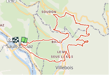
Tour Wandern von 14,3 km verfügbar auf Auvergne-Rhone-Alpen, Ain, Sault-Brénaz. Diese Tour wird von patpounet73 vorgeschlagen.
Beschreibung
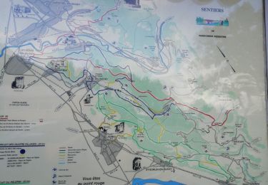
Randonnée sans grandes difficultés exceptés la traversée des 2 ruisseaux, au niveau de Les Choux, qui peut s'avérer compliquée après des pluies.
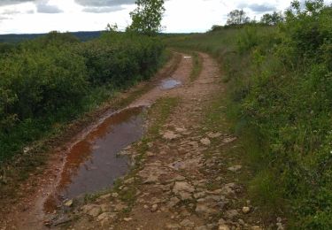
Après Soudon, le chemin des Vignes du Crêt s'éboule. Obstacle pouvant être contourné en allant directement sur le Crêt.
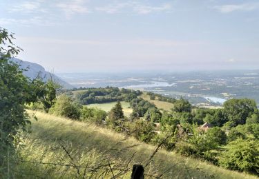
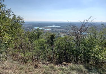
Très belle vue sur le Rhône et la plaine au niveau du belvédère de la Croix de Grassonnet.
Ort
Kommentare
Touren in der Umgebung
![Tour Wandern Saint-Sorlin-en-Bugey - 20140331 Tour de Saint Sorlin - Photo](https://media.geolcdn.com/t/375/260/ext.jpg?maxdim=2&url=https%3A%2F%2Fstatic1.geolcdn.com%2Fsiteimages%2Fupload%2Ffiles%2F1553511878bg_sport_marche.png)
![Wandern Wandern](https://static1.geolcdn.com/sitytour/trail-icons/101.png)
Wandern
![](/images/other/stat-length.png)
![](https://static1.geolcdn.com/siteimages/upload/files/16400158638029165_repeat_loop_refresh_sync_direction_icon.png)
![Tour Wandern Souclin - 01 st sorlin en bugey - Photo](https://media.geolcdn.com/t/375/260/cf490a6f-a08f-4140-856b-a9dab8df298c.jpg&format=jpg&maxdim=2)
![Wandern Wandern](https://static1.geolcdn.com/sitytour/trail-icons/101.png)
Wandern
![](/images/other/stat-length.png)
![](https://static1.geolcdn.com/siteimages/upload/files/16400158638029165_repeat_loop_refresh_sync_direction_icon.png)
![Tour Wandern Souclin - 01-soudon-cleyzieu-20km825m - Photo](https://media.geolcdn.com/t/375/260/0346293c-b114-4c04-91d5-976f9c67f4c8.jpg&format=jpg&maxdim=2)
![Wandern Wandern](https://static1.geolcdn.com/sitytour/trail-icons/101.png)
Wandern
![](/images/other/stat-length.png)
![](https://static1.geolcdn.com/siteimages/upload/files/16400158638029165_repeat_loop_refresh_sync_direction_icon.png)
![Tour Wandern Sault-Brénaz - 18 novembre 2022 Sault Brenat - Photo](https://media.geolcdn.com/t/375/260/aa92b50a-0f25-45d5-b589-dc4b5b0164e0.jpg&format=jpg&maxdim=2)
![Wandern Wandern](https://static1.geolcdn.com/sitytour/trail-icons/101.png)
Wandern
![](/images/other/stat-length.png)
![](https://static1.geolcdn.com/siteimages/upload/files/16400158638029165_repeat_loop_refresh_sync_direction_icon.png)
![Tour Wandern Villebois - les balcons de souclin hameau de buis - Photo](https://media.geolcdn.com/t/375/260/3b5f007f-b409-4554-ba2e-def6bfe006e4.jpg&format=jpg&maxdim=2)
![Wandern Wandern](https://static1.geolcdn.com/sitytour/trail-icons/101.png)
Wandern
![](/images/other/stat-length.png)
![](https://static1.geolcdn.com/siteimages/upload/files/16400158638029165_repeat_loop_refresh_sync_direction_icon.png)
![Tour Wandern Sault-Brénaz - 01-Sault-Brenaz-18.5km-740m-sept22 - Photo](https://media.geolcdn.com/t/375/260/b5bf9773-a9dc-4a2f-9fba-5d304d03ce5e.jpg&format=jpg&maxdim=2)
![Wandern Wandern](https://static1.geolcdn.com/sitytour/trail-icons/101.png)
Wandern
![](/images/other/stat-length.png)
![](https://static1.geolcdn.com/siteimages/upload/files/16400158638029165_repeat_loop_refresh_sync_direction_icon.png)
![Tour Wandern Saint-Sorlin-en-Bugey - 01-St-Sorlin-Bugey-17km-680m-aout21 - Photo](https://media.geolcdn.com/t/375/260/aaf32497-5de5-4642-befb-7c29012fe28b.jpg&format=jpg&maxdim=2)
![Wandern Wandern](https://static1.geolcdn.com/sitytour/trail-icons/101.png)
Wandern
![](/images/other/stat-length.png)
![](https://static1.geolcdn.com/siteimages/upload/files/16400158638029165_repeat_loop_refresh_sync_direction_icon.png)
![Tour Mountainbike Parmilieu - Parmilieu 10 2014 - Photo](https://media.geolcdn.com/t/375/260/ext.jpg?maxdim=2&url=https%3A%2F%2Fstatic1.geolcdn.com%2Fsiteimages%2Fupload%2Ffiles%2F1524743154velo.jpg)
![Mountainbike Mountainbike](https://static1.geolcdn.com/sitytour/trail-icons/202.png)
Mountainbike
![](/images/other/stat-length.png)
![](https://static1.geolcdn.com/siteimages/upload/files/16400158638029165_repeat_loop_refresh_sync_direction_icon.png)
![Tour Elektrofahrrad Montalieu-Vercieu - Le Tour de la Vallée Bleue en VAE - Photo](https://media.geolcdn.com/t/375/260/9253f46c-1312-4f3d-b4d2-f49e4324aa30.jpg&format=jpg&maxdim=2)
![Elektrofahrrad Elektrofahrrad](https://static1.geolcdn.com/sitytour/trail-icons/205.png)
Elektrofahrrad
![](/images/other/stat-length.png)
![](https://static1.geolcdn.com/siteimages/upload/files/16400158638029165_repeat_loop_refresh_sync_direction_icon.png)