![](/images/other/stat-length.png)
![Tour Zu Fuß Houyet - Gendron-Celles - Photo](https://media.geolcdn.com/t/1900/400/ext.pjpeg?maxdim=2&url=https%3A%2F%2Fstatic1.geolcdn.com%2Fsiteimages%2Fupload%2Ffiles%2F1545311037marcheuse_200dpi.jpg)
Gendron-Celles
r.genette
Benutzer
![Länge](/images/other/stat-length.png)
Länge
9,1 km
![Maximale Höhe](https://static1.geolcdn.com/siteimages/upload/files/1508320355ic_sort_altitude_max_24dp.png)
Maximale Höhe
240 m
![Positive Höhendifferenz](https://static1.geolcdn.com/siteimages/upload/files/1508320355ic_sort_den_pos_24dp.png)
Positive Höhendifferenz
228 m
![Km-Effort](/images/other/stat-length.png)
Km-Effort
12,1 km
![Min. Höhe](https://static1.geolcdn.com/siteimages/upload/files/1508320355ic_sort_altitude_min_24dp.png)
Min. Höhe
109 m
![Negative Höhendifferenz](https://static1.geolcdn.com/siteimages/upload/files/1508320355ic_sort_den_neg_24dp.png)
Negative Höhendifferenz
235 m
![Boucle](https://static1.geolcdn.com/siteimages/upload/files/16400158638029165_repeat_loop_refresh_sync_direction_icon.png)
Boucle
Ja
Erstellungsdatum :
2021-03-01 12:38:44.045
Letzte Änderung :
2021-03-02 09:33:16.692
![Zu Fuß](https://static1.geolcdn.com/sitytour/trail-icons/100.png)
3h00
Schwierigkeit : Medium
![Scannen Sie diesen QR-Code, um die Tour in der SityTrail-Anwendung zu öffnen](https://capi.geolives.com/qq0zvz2zws4bq2lad0pu/sitytour/trails/2691056/qr.png?size=200)
Kostenlosegpshiking-Anwendung
Über SityTrail
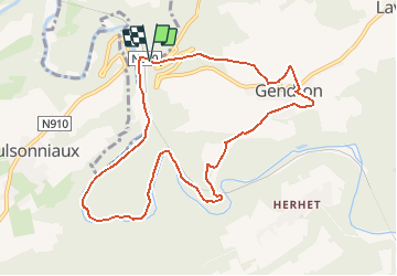
Tour Zu Fuß von 9,1 km verfügbar auf Wallonien, Namur, Houyet. Diese Tour wird von r.genette vorgeschlagen.
Beschreibung
Depuis parking hôtel restaurant Auberge de la Lesse.. vers Gendron.. la vallée de la Lesse.. et retour..
Des dénivelés, des chemins où la prudence s'impose.... mais assez faciles
Ort
Land:
Belgium
Region :
Wallonien
Abteilung/Provinz :
Namur
Kommune :
Houyet
Standort:
Celles
Gehen Sie:(Dec)
Gehen Sie:(UTM)
640254 ; 5563949 (31U) N.
Kommentare
Touren in der Umgebung
![Wandern Wandern](https://static1.geolcdn.com/sitytour/trail-icons/101.png)
RB-Na-24-Entre Lesse et Meuse
Wandern
Sehr schwierig
(15)
Dinant,
Wallonien,
Namur,
Belgium
![](/images/other/stat-length.png)
19,3 km | 26 km-effort
5h 57min
![](https://static1.geolcdn.com/siteimages/upload/files/16400158638029165_repeat_loop_refresh_sync_direction_icon.png)
Ja
![Tour Wandern Houyet - Nature - The Payenne trail (Houyet) - Photo](https://media.geolcdn.com/t/375/260/ext.jpg?maxdim=2&url=https%3A%2F%2Fservices.sitytrail.com%2FGeolivesWS%2FDownloadMedia.ashx%3FTrailID%3D247221%26Media%3D4a1116e4-3cc3-4f81-a279-87cb261b0cef.jpg)
![Wandern Wandern](https://static1.geolcdn.com/sitytour/trail-icons/101.png)
Nature - The Payenne trail (Houyet)
Wandern
Schwierig
(5)
Houyet,
Wallonien,
Namur,
Belgium
![](/images/other/stat-length.png)
14,3 km | 19 km-effort
4h 18min
![](https://static1.geolcdn.com/siteimages/upload/files/16400158638029165_repeat_loop_refresh_sync_direction_icon.png)
Ja
![Tour Wandern Houyet - Nature - Royal Park walk - Houyet - Photo](https://media.geolcdn.com/t/375/260/ext.jpg?maxdim=2&url=https%3A%2F%2Fservices.sitytrail.com%2FGeolivesWS%2FDownloadMedia.ashx%3FTrailID%3D193546%26Media%3D0a2a8593-cf69-475f-a9b0-b2a4af4f959b.jpg)
![Wandern Wandern](https://static1.geolcdn.com/sitytour/trail-icons/101.png)
Nature - Royal Park walk - Houyet
Wandern
Schwierig
(14)
Houyet,
Wallonien,
Namur,
Belgium
![](/images/other/stat-length.png)
5,7 km | 7,8 km-effort
1h 47min
![](https://static1.geolcdn.com/siteimages/upload/files/16400158638029165_repeat_loop_refresh_sync_direction_icon.png)
Ja
![Tour Wandern Houyet - Houyet - Pî-sinte po tortos - Walk for everyone - On foot, by bicycle, on horseback, wheelchair accessible - Photo](https://media.geolcdn.com/t/375/260/ext.jpg?maxdim=2&url=https%3A%2F%2Fservices.sitytrail.com%2FGeolivesWS%2FDownloadMedia.ashx%3FTrailID%3D193539%26Media%3D6b85272b-deee-4a79-9526-05b6bf74491c.jpg)
![Wandern Wandern](https://static1.geolcdn.com/sitytour/trail-icons/101.png)
Houyet - Pî-sinte po tortos - Walk for everyone - On foot, by bicycle, on ho...
Wandern
(6)
Houyet,
Wallonien,
Namur,
Belgium
![](/images/other/stat-length.png)
4,3 km | 4,9 km-effort
1h 0min
![](https://static1.geolcdn.com/siteimages/upload/files/16400158638029165_repeat_loop_refresh_sync_direction_icon.png)
Ja
![Tour Wandern Houyet - La Lesse, Natura 2000 - Des sites qui valent le détour, Na07 - Photo](https://media.geolcdn.com/t/375/260/ext.jpg?maxdim=2&url=https%3A%2F%2Fservices.sitytrail.com%2FGeolivesWS%2FDownloadMedia.ashx%3FTrailID%3D188163%26Media%3Df0b29f0e-e19a-4fa8-a869-5ab27b1769d7.JPG)
![Wandern Wandern](https://static1.geolcdn.com/sitytour/trail-icons/101.png)
La Lesse, Natura 2000 - Des sites qui valent le détour, Na07
Wandern
Schwierig
(9)
Houyet,
Wallonien,
Namur,
Belgium
![](/images/other/stat-length.png)
8,8 km | 11,5 km-effort
2h 33min
![](https://static1.geolcdn.com/siteimages/upload/files/16400158638029165_repeat_loop_refresh_sync_direction_icon.png)
Ja
![Tour Wandern Houyet - RB-Na-05 Hauts lieux de la basse Lesse - Photo](https://media.geolcdn.com/t/375/260/ext.jpg?maxdim=2&url=https%3A%2F%2Fservices.sitytrail.com%2FGeolivesWS%2FDownloadMedia.ashx%3FTrailID%3D179631%26Media%3D95d7547e-2b07-4681-8a2a-4a37901ae9c7.jpg)
![Wandern Wandern](https://static1.geolcdn.com/sitytour/trail-icons/101.png)
RB-Na-05 Hauts lieux de la basse Lesse
Wandern
Medium
(9)
Houyet,
Wallonien,
Namur,
Belgium
![](/images/other/stat-length.png)
24 km | 31 km-effort
6h 33min
![](https://static1.geolcdn.com/siteimages/upload/files/16400158638029165_repeat_loop_refresh_sync_direction_icon.png)
Ja
![Tour Wandern Houyet - Nature - Houyet, a royal municipality - Photo](https://media.geolcdn.com/t/375/260/ext.jpg?maxdim=2&url=https%3A%2F%2Fservices.sitytrail.com%2FGeolivesWS%2FDownloadMedia.ashx%3FTrailID%3D166040%26Media%3D0a2a8593-cf69-475f-a9b0-b2a4af4f959b.jpg)
![Wandern Wandern](https://static1.geolcdn.com/sitytour/trail-icons/101.png)
Nature - Houyet, a royal municipality
Wandern
Schwierig
(14)
Houyet,
Wallonien,
Namur,
Belgium
![](/images/other/stat-length.png)
8,3 km | 11,5 km-effort
2h 33min
![](https://static1.geolcdn.com/siteimages/upload/files/16400158638029165_repeat_loop_refresh_sync_direction_icon.png)
Ja
![Tour Wandern Houyet - RB-Na-05 Raccourci 1 - Hauts lieux de la basse Lesse - Photo](https://media.geolcdn.com/t/375/260/ext.jpg?maxdim=2&url=https%3A%2F%2Fservices.sitytrail.com%2FGeolivesWS%2FDownloadMedia.ashx%3FTrailID%3D213753%26Media%3D8bab1d47-4651-4050-8b88-78bf90d52eb5.jpg)
![Wandern Wandern](https://static1.geolcdn.com/sitytour/trail-icons/101.png)
RB-Na-05 Raccourci 1 - Hauts lieux de la basse Lesse
Wandern
Einfach
(5)
Houyet,
Wallonien,
Namur,
Belgium
![](/images/other/stat-length.png)
21 km | 26 km-effort
5h 37min
![](https://static1.geolcdn.com/siteimages/upload/files/16400158638029165_repeat_loop_refresh_sync_direction_icon.png)
Ja
![Tour Wandern Houyet - Nature & heritage in Celles, one of the Most Beautiful Villages of Wallonia - Photo](https://media.geolcdn.com/t/375/260/ac9d387c-3f8d-401d-bffe-044b71ce3eff.jpg&format=jpg&maxdim=2)
![Wandern Wandern](https://static1.geolcdn.com/sitytour/trail-icons/101.png)
Nature & heritage in Celles, one of the Most Beautiful Villages of Wallonia
Wandern
Medium
(6)
Houyet,
Wallonien,
Namur,
Belgium
![](/images/other/stat-length.png)
9,6 km | 12,7 km-effort
2h 52min
![](https://static1.geolcdn.com/siteimages/upload/files/16400158638029165_repeat_loop_refresh_sync_direction_icon.png)
Ja