![](/images/other/stat-length.png)
![Tour Wandern La Cadière-d'Azur - la Cadière d azur st Cyr sur mer - Photo](https://media.geolcdn.com/t/1900/400/b00cc7e2-7f7e-4a9b-a4d4-f87c129068bf.jpg&format=pjpeg&maxdim=2)
la Cadière d azur st Cyr sur mer
chrifor
Benutzer
![Länge](/images/other/stat-length.png)
Länge
16,4 km
![Maximale Höhe](https://static1.geolcdn.com/siteimages/upload/files/1508320355ic_sort_altitude_max_24dp.png)
Maximale Höhe
226 m
![Positive Höhendifferenz](https://static1.geolcdn.com/siteimages/upload/files/1508320355ic_sort_den_pos_24dp.png)
Positive Höhendifferenz
481 m
![Km-Effort](/images/other/stat-length.png)
Km-Effort
23 km
![Min. Höhe](https://static1.geolcdn.com/siteimages/upload/files/1508320355ic_sort_altitude_min_24dp.png)
Min. Höhe
22 m
![Negative Höhendifferenz](https://static1.geolcdn.com/siteimages/upload/files/1508320355ic_sort_den_neg_24dp.png)
Negative Höhendifferenz
481 m
![Boucle](https://static1.geolcdn.com/siteimages/upload/files/16400158638029165_repeat_loop_refresh_sync_direction_icon.png)
Boucle
Ja
Erstellungsdatum :
2021-02-24 08:39:31.413
Letzte Änderung :
2021-02-25 10:34:40.132
![Wandern](https://static1.geolcdn.com/sitytour/trail-icons/101.png)
5h52
Schwierigkeit : Medium
![Scannen Sie diesen QR-Code, um die Tour in der SityTrail-Anwendung zu öffnen](https://capi.geolives.com/qq0zvz2zws4bq2lad0pu/sitytour/trails/2683484/qr.png?size=200)
Kostenlosegpshiking-Anwendung
Über SityTrail
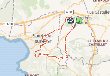
Tour Wandern von 16,4 km verfügbar auf Provence-Alpes-Côte d'Azur, Var, La Cadière-d'Azur. Diese Tour wird von chrifor vorgeschlagen.
Beschreibung
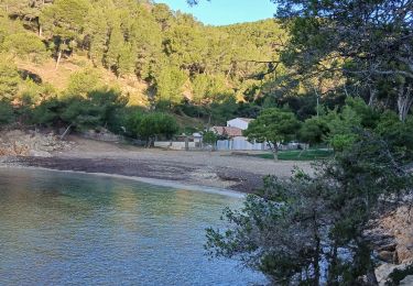
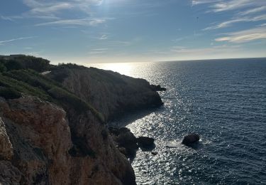
Randonnée (parcourue) agréable entre pinède, vignes et vue sur la sainte Baume et la mer ...si la brume marine n'est pas de la fête!
Ort
Land:
France
Region :
Provence-Alpes-Côte d'Azur
Abteilung/Provinz :
Var
Kommune :
La Cadière-d'Azur
Standort:
Unknown
Gehen Sie:(Dec)
Gehen Sie:(UTM)
723277 ; 4785568 (31T) N.
Kommentare
Touren in der Umgebung
![Tour Wandern Saint-Cyr-sur-Mer - St Cyr - Bandol - Photo](https://media.geolcdn.com/t/375/260/ext.jpg?maxdim=2&url=https%3A%2F%2Fservices.sitytrail.com%2FGeolivesWS%2FDownloadMedia.ashx%3FTrailID%3D746530%26Media%3Dfix__20170505150639.jpg)
![Wandern Wandern](https://static1.geolcdn.com/sitytour/trail-icons/101.png)
St Cyr - Bandol
Wandern
Medium
(1)
Saint-Cyr-sur-Mer,
Provence-Alpes-Côte d'Azur,
Var,
France
![](/images/other/stat-length.png)
16,1 km | 21 km-effort
4h 53min
![](https://static1.geolcdn.com/siteimages/upload/files/16400158638029165_repeat_loop_refresh_sync_direction_icon.png)
Nein
![Tour Wandern Saint-Cyr-sur-Mer - Port d'Alon - Bandol - Port d'Alon - Photo](https://media.geolcdn.com/t/375/260/ext.jpg?maxdim=2&url=https%3A%2F%2Fservices.sitytrail.com%2FGeolivesWS%2FDownloadMedia.ashx%3FTrailID%3D103920%26Media%3D6771_1.jpg)
![Wandern Wandern](https://static1.geolcdn.com/sitytour/trail-icons/101.png)
Port d'Alon - Bandol - Port d'Alon
Wandern
Medium
(1)
Saint-Cyr-sur-Mer,
Provence-Alpes-Côte d'Azur,
Var,
France
![](/images/other/stat-length.png)
7,7 km | 9,9 km-effort
2h 0min
![](https://static1.geolcdn.com/siteimages/upload/files/16400158638029165_repeat_loop_refresh_sync_direction_icon.png)
Ja
![Tour Wandern Saint-Cyr-sur-Mer - Le Port d'Alon - Photo](https://media.geolcdn.com/t/375/260/ext.jpg?maxdim=2&url=https%3A%2F%2Fservices.sitytrail.com%2FGeolivesWS%2FDownloadMedia.ashx%3FTrailID%3D103916%26Media%3D6764_1.jpg)
![Wandern Wandern](https://static1.geolcdn.com/sitytour/trail-icons/101.png)
Le Port d'Alon
Wandern
Medium
(2)
Saint-Cyr-sur-Mer,
Provence-Alpes-Côte d'Azur,
Var,
France
![](/images/other/stat-length.png)
9,4 km | 12,8 km-effort
3h 0min
![](https://static1.geolcdn.com/siteimages/upload/files/16400158638029165_repeat_loop_refresh_sync_direction_icon.png)
Ja
![Tour Nordic Walking La Cadière-d'Azur - 20220329_La Cadière d'Azur - Photo](https://media.geolcdn.com/t/375/260/ext.jpg?maxdim=2&url=https%3A%2F%2Fstatic1.geolcdn.com%2Fsiteimages%2Fupload%2Ffiles%2F1545311037marcheuse_200dpi.jpg)
![Nordic Walking Nordic Walking](https://static1.geolcdn.com/sitytour/trail-icons/102.png)
20220329_La Cadière d'Azur
Nordic Walking
Sehr leicht
(1)
La Cadière-d'Azur,
Provence-Alpes-Côte d'Azur,
Var,
France
![](/images/other/stat-length.png)
6,8 km | 8,6 km-effort
1h 30min
![](https://static1.geolcdn.com/siteimages/upload/files/16400158638029165_repeat_loop_refresh_sync_direction_icon.png)
Ja
![Tour Wandern Saint-Cyr-sur-Mer - le sentier littoral de la Madrague et la colline de sable - Photo](https://media.geolcdn.com/t/375/260/ext.jpg?maxdim=2&url=https%3A%2F%2Fservices.sitytrail.com%2FGeolivesWS%2FDownloadMedia.ashx%3FTrailID%3D485513%26Media%3D21ba94d9-fd64-486b-9460-9884fbc5235d.JPG)
![Wandern Wandern](https://static1.geolcdn.com/sitytour/trail-icons/101.png)
le sentier littoral de la Madrague et la colline de sable
Wandern
Einfach
(1)
Saint-Cyr-sur-Mer,
Provence-Alpes-Côte d'Azur,
Var,
France
![](/images/other/stat-length.png)
13 km | 18,7 km-effort
5h 20min
![](https://static1.geolcdn.com/siteimages/upload/files/16400158638029165_repeat_loop_refresh_sync_direction_icon.png)
Ja
![Tour Wandern Saint-Cyr-sur-Mer - La Gâche- St Cyr sur Mer- 29-11-2024 - Photo](https://media.geolcdn.com/t/375/260/74b3ee85-6261-4e61-be67-fc3bcc2f98f4.jpg&format=jpg&maxdim=2)
![Wandern Wandern](https://static1.geolcdn.com/sitytour/trail-icons/101.png)
La Gâche- St Cyr sur Mer- 29-11-2024
Wandern
Medium
Saint-Cyr-sur-Mer,
Provence-Alpes-Côte d'Azur,
Var,
France
![](/images/other/stat-length.png)
12,9 km | 19 km-effort
3h 46min
![](https://static1.geolcdn.com/siteimages/upload/files/16400158638029165_repeat_loop_refresh_sync_direction_icon.png)
Ja
![Tour Wandern Saint-Cyr-sur-Mer - Port d Alon - Photo](https://media.geolcdn.com/t/375/260/1c13af96-833f-419a-8687-a5f0fa702766.jpg&format=jpg&maxdim=2)
![Wandern Wandern](https://static1.geolcdn.com/sitytour/trail-icons/101.png)
Port d Alon
Wandern
Medium
Saint-Cyr-sur-Mer,
Provence-Alpes-Côte d'Azur,
Var,
France
![](/images/other/stat-length.png)
11,8 km | 16,6 km-effort
3h 54min
![](https://static1.geolcdn.com/siteimages/upload/files/16400158638029165_repeat_loop_refresh_sync_direction_icon.png)
Ja
![Tour Wandern La Cadière-d'Azur - LA CADIERE - Photo](https://media.geolcdn.com/t/375/260/a2408c77-3028-41f8-8edb-6dd660fdfb6a.jpg&format=jpg&maxdim=2)
![Wandern Wandern](https://static1.geolcdn.com/sitytour/trail-icons/101.png)
LA CADIERE
Wandern
Medium
(1)
La Cadière-d'Azur,
Provence-Alpes-Côte d'Azur,
Var,
France
![](/images/other/stat-length.png)
10,4 km | 14,4 km-effort
3h 16min
![](https://static1.geolcdn.com/siteimages/upload/files/16400158638029165_repeat_loop_refresh_sync_direction_icon.png)
Ja