![](/images/other/stat-length.png)
![Tour Wandern Vresse-sur-Semois - Alle Cornimont Chairière via le Mont d'Aule 11 km 460 m DP - Photo](https://media.geolcdn.com/t/1900/400/4d157215-b5cc-4db4-96e1-cb550c72e465.jpg&format=pjpeg&maxdim=2)
Alle Cornimont Chairière via le Mont d'Aule 11 km 460 m DP
ramagufa
Benutzer
![Länge](/images/other/stat-length.png)
Länge
11,4 km
![Maximale Höhe](https://static1.geolcdn.com/siteimages/upload/files/1508320355ic_sort_altitude_max_24dp.png)
Maximale Höhe
432 m
![Positive Höhendifferenz](https://static1.geolcdn.com/siteimages/upload/files/1508320355ic_sort_den_pos_24dp.png)
Positive Höhendifferenz
460 m
![Km-Effort](/images/other/stat-length.png)
Km-Effort
17,5 km
![Min. Höhe](https://static1.geolcdn.com/siteimages/upload/files/1508320355ic_sort_altitude_min_24dp.png)
Min. Höhe
185 m
![Negative Höhendifferenz](https://static1.geolcdn.com/siteimages/upload/files/1508320355ic_sort_den_neg_24dp.png)
Negative Höhendifferenz
462 m
![Boucle](https://static1.geolcdn.com/siteimages/upload/files/16400158638029165_repeat_loop_refresh_sync_direction_icon.png)
Boucle
Ja
Erstellungsdatum :
2021-02-24 13:26:39.633
Letzte Änderung :
2021-02-24 19:18:16.863
![Wandern](https://static1.geolcdn.com/sitytour/trail-icons/101.png)
1h17
Schwierigkeit : Schwierig
![Scannen Sie diesen QR-Code, um die Tour in der SityTrail-Anwendung zu öffnen](https://capi.geolives.com/qq0zvz2zws4bq2lad0pu/sitytour/trails/2683291/qr.png?size=200)
Kostenlosegpshiking-Anwendung
Über SityTrail
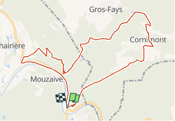
Tour Wandern von 11,4 km verfügbar auf Wallonien, Namur, Vresse-sur-Semois. Diese Tour wird von ramagufa vorgeschlagen.
Beschreibung
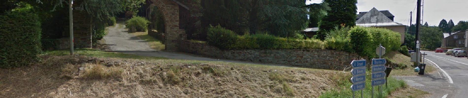
Aa carrefour de la route de Alle et celle de Rochehaut, prendre la rando sous le porche en pierre qui vous envoie vers le bois du Fief de Liboichamps.
Ort
Land:
Belgium
Region :
Wallonien
Abteilung/Provinz :
Namur
Kommune :
Vresse-sur-Semois
Standort:
Chairière
Gehen Sie:(Dec)
Gehen Sie:(UTM)
641598 ; 5523456 (31U) N.
Kommentare
Touren in der Umgebung
![Tour Wandern Bouillon - RB-Lu-12 - Premier contact avec la Semois au Tombeau du Géant - Photo](https://media.geolcdn.com/t/375/260/ext.jpg?maxdim=2&url=https%3A%2F%2Fservices.sitytrail.com%2FGeolivesWS%2FDownloadMedia.ashx%3FTrailID%3D179617%26Media%3Dd1ff11f2-43fb-4a27-8679-182dbfec36f0.jpg)
![Wandern Wandern](https://static1.geolcdn.com/sitytour/trail-icons/101.png)
RB-Lu-12 - Premier contact avec la Semois au Tombeau du Géant
Wandern
Sehr schwierig
(6)
Bouillon,
Wallonien,
Luxemburg,
Belgium
![](/images/other/stat-length.png)
19,1 km | 27 km-effort
6h 7min
![](https://static1.geolcdn.com/siteimages/upload/files/16400158638029165_repeat_loop_refresh_sync_direction_icon.png)
Ja
![Wandern Wandern](https://static1.geolcdn.com/sitytour/trail-icons/101.png)
Rb-Na-32-Racc_Sur-les-rampes-escarpées-de-la-vallée-de-la-Semois
Wandern
Sehr schwierig
(2)
Vresse-sur-Semois,
Wallonien,
Namur,
Belgium
![](/images/other/stat-length.png)
14,7 km | 23 km-effort
5h 14min
![](https://static1.geolcdn.com/siteimages/upload/files/16400158638029165_repeat_loop_refresh_sync_direction_icon.png)
Ja
![Wandern Wandern](https://static1.geolcdn.com/sitytour/trail-icons/101.png)
Rb-Na-32_Sur les rampes escarpées de la vallée de la Semois
Wandern
Sehr schwierig
(2)
Vresse-sur-Semois,
Wallonien,
Namur,
Belgium
![](/images/other/stat-length.png)
19,8 km | 31 km-effort
7h 5min
![](https://static1.geolcdn.com/siteimages/upload/files/16400158638029165_repeat_loop_refresh_sync_direction_icon.png)
Ja
![Tour Wandern Vresse-sur-Semois - RB-Na-09 Variante estivale - L Ardenne des eaux vives - Photo](https://media.geolcdn.com/t/375/260/ext.jpg?maxdim=2&url=https%3A%2F%2Fservices.sitytrail.com%2FGeolivesWS%2FDownloadMedia.ashx%3FTrailID%3D794164%26Media%3D60b701e1-87e7-4c45-96c1-6064d8879e37.jpg)
![Wandern Wandern](https://static1.geolcdn.com/sitytour/trail-icons/101.png)
RB-Na-09 Variante estivale - L Ardenne des eaux vives
Wandern
Medium
(3)
Vresse-sur-Semois,
Wallonien,
Namur,
Belgium
![](/images/other/stat-length.png)
23 km | 33 km-effort
6h 41min
![](https://static1.geolcdn.com/siteimages/upload/files/16400158638029165_repeat_loop_refresh_sync_direction_icon.png)
Ja
![Tour Wandern Vresse-sur-Semois - RB-Na-09 Raccourci - L Ardenne des eaux vives - Photo](https://media.geolcdn.com/t/375/260/ext.jpg?maxdim=2&url=https%3A%2F%2Fservices.sitytrail.com%2FGeolivesWS%2FDownloadMedia.ashx%3FTrailID%3D262313%26Media%3D60b701e1-87e7-4c45-96c1-6064d8879e37.jpg)
![Wandern Wandern](https://static1.geolcdn.com/sitytour/trail-icons/101.png)
RB-Na-09 Raccourci - L Ardenne des eaux vives
Wandern
Medium
(2)
Vresse-sur-Semois,
Wallonien,
Namur,
Belgium
![](/images/other/stat-length.png)
17 km | 24 km-effort
5h 7min
![](https://static1.geolcdn.com/siteimages/upload/files/16400158638029165_repeat_loop_refresh_sync_direction_icon.png)
Ja
![Tour Wandern Vresse-sur-Semois - RB-Na-09 L'Ardenne des eaux vives - Photo](https://media.geolcdn.com/t/375/260/ext.jpg?maxdim=2&url=https%3A%2F%2Fservices.sitytrail.com%2FGeolivesWS%2FDownloadMedia.ashx%3FTrailID%3D260987%26Media%3Db97841e8-b1a3-4e80-a9b6-aaa2b671bafd.jpg)
![Wandern Wandern](https://static1.geolcdn.com/sitytour/trail-icons/101.png)
RB-Na-09 L'Ardenne des eaux vives
Wandern
Medium
(4)
Vresse-sur-Semois,
Wallonien,
Namur,
Belgium
![](/images/other/stat-length.png)
22 km | 32 km-effort
6h 41min
![](https://static1.geolcdn.com/siteimages/upload/files/16400158638029165_repeat_loop_refresh_sync_direction_icon.png)
Ja
![Tour Wandern Vresse-sur-Semois - La Semois. Natura 2000, des sites qui valent le détour. Na3 - Photo](https://media.geolcdn.com/t/375/260/ext.jpg?maxdim=2&url=https%3A%2F%2Fservices.sitytrail.com%2FGeolivesWS%2FDownloadMedia.ashx%3FTrailID%3D163715%26Media%3Dda40f5b3-1e4b-4509-ae3e-d9dafa1466cc.JPG)
![Wandern Wandern](https://static1.geolcdn.com/sitytour/trail-icons/101.png)
La Semois. Natura 2000, des sites qui valent le détour. Na3
Wandern
Medium
(3)
Vresse-sur-Semois,
Wallonien,
Namur,
Belgium
![](/images/other/stat-length.png)
13 km | 17,5 km-effort
3h 46min
![](https://static1.geolcdn.com/siteimages/upload/files/16400158638029165_repeat_loop_refresh_sync_direction_icon.png)
Ja
![Tour Wandern Vresse-sur-Semois - Vresse-sur-Semois. Natura 2000, des fiches qui valent le détour ! Na1 - Photo](https://media.geolcdn.com/t/375/260/ext.jpg?maxdim=2&url=https%3A%2F%2Fservices.sitytrail.com%2FGeolivesWS%2FDownloadMedia.ashx%3FTrailID%3D161419%26Media%3D7f9dfac9-cf3f-4279-ae43-0aba8e08a963.JPG)
![Wandern Wandern](https://static1.geolcdn.com/sitytour/trail-icons/101.png)
Vresse-sur-Semois. Natura 2000, des fiches qui valent le détour ! Na1
Wandern
Medium
(3)
Vresse-sur-Semois,
Wallonien,
Namur,
Belgium
![](/images/other/stat-length.png)
9,3 km | 14 km-effort
2h 56min
![](https://static1.geolcdn.com/siteimages/upload/files/16400158638029165_repeat_loop_refresh_sync_direction_icon.png)
Ja
![Tour Wandern Bouillon - De Poupehan à Frahan par le sentier des crêtes - Photo](https://media.geolcdn.com/t/375/260/ext.jpg?maxdim=2&url=https%3A%2F%2Fservices.sitytrail.com%2FGeolivesWS%2FDownloadMedia.ashx%3FTrailID%3D138478%26Media%3Db86d13b9-d40b-4a52-ab60-15a552c97303.JPG)
![Wandern Wandern](https://static1.geolcdn.com/sitytour/trail-icons/101.png)
De Poupehan à Frahan par le sentier des crêtes
Wandern
Medium
(3)
Bouillon,
Wallonien,
Luxemburg,
Belgium
![](/images/other/stat-length.png)
8,8 km | 12,5 km-effort
3h 0min
![](https://static1.geolcdn.com/siteimages/upload/files/16400158638029165_repeat_loop_refresh_sync_direction_icon.png)
Ja