![](/images/other/stat-length.png)
![Tour Zu Fuß Servon - L 26 5.82 km Eglise de Santeny, châteaux de Choigny et Villemenon - Photo](https://media.geolcdn.com/t/1900/400/ext.pjpeg?maxdim=2&url=https%3A%2F%2Fstatic1.geolcdn.com%2Fsiteimages%2Fupload%2Ffiles%2F1545311037marcheuse_200dpi.jpg)
L 26 5.82 km Eglise de Santeny, châteaux de Choigny et Villemenon
Les 1000 pattes
Club randonnées SERVON
![Länge](/images/other/stat-length.png)
Länge
5,6 km
![Maximale Höhe](https://static1.geolcdn.com/siteimages/upload/files/1508320355ic_sort_altitude_max_24dp.png)
Maximale Höhe
94 m
![Positive Höhendifferenz](https://static1.geolcdn.com/siteimages/upload/files/1508320355ic_sort_den_pos_24dp.png)
Positive Höhendifferenz
61 m
![Km-Effort](/images/other/stat-length.png)
Km-Effort
6,4 km
![Min. Höhe](https://static1.geolcdn.com/siteimages/upload/files/1508320355ic_sort_altitude_min_24dp.png)
Min. Höhe
66 m
![Negative Höhendifferenz](https://static1.geolcdn.com/siteimages/upload/files/1508320355ic_sort_den_neg_24dp.png)
Negative Höhendifferenz
61 m
![Boucle](https://static1.geolcdn.com/siteimages/upload/files/16400158638029165_repeat_loop_refresh_sync_direction_icon.png)
Boucle
Ja
Erstellungsdatum :
2021-02-23 15:55:26.499
Letzte Änderung :
2024-11-27 09:54:08.908
![Zu Fuß](https://static1.geolcdn.com/sitytour/trail-icons/100.png)
1h27
Schwierigkeit : Sehr leicht
![Scannen Sie diesen QR-Code, um die Tour in der SityTrail-Anwendung zu öffnen](https://capi.geolives.com/qq0zvz2zws4bq2lad0pu/sitytour/trails/2682330/qr.png?size=200)
Kostenlosegpshiking-Anwendung
Über SityTrail
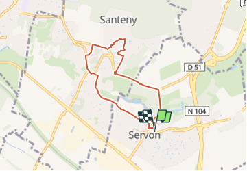
Tour Zu Fuß von 5,6 km verfügbar auf Île-de-France, Seine-et-Marne, Servon. Diese Tour wird von Les 1000 pattes vorgeschlagen.
Beschreibung
la dehors, Santeny : rue de la cavette, rue de l'église, Domaine de Santeny, allée du Grand Duc, Château de Choigny, Château de Villemenon, Coeur Servon.
Ort
Land:
France
Region :
Île-de-France
Abteilung/Provinz :
Seine-et-Marne
Kommune :
Servon
Standort:
Unknown
Gehen Sie:(Dec)
Gehen Sie:(UTM)
469693 ; 5395986 (31U) N.
Kommentare
Touren in der Umgebung
![Tour Zu Fuß Marolles-en-Brie - L 48 Les Bagaudes et parcours sportif de Sucy 5,7 km - Photo](https://media.geolcdn.com/t/375/260/ext.jpg?maxdim=2&url=https%3A%2F%2Fstatic1.geolcdn.com%2Fsiteimages%2Fupload%2Ffiles%2F1545311037marcheuse_200dpi.jpg)
![Zu Fuß Zu Fuß](https://static1.geolcdn.com/sitytour/trail-icons/100.png)
L 48 Les Bagaudes et parcours sportif de Sucy 5,7 km
Zu Fuß
Sehr leicht
(5)
Marolles-en-Brie,
Île-de-France,
Val-de-Marne,
France
![](/images/other/stat-length.png)
6 km | 6,6 km-effort
1h 29min
![](https://static1.geolcdn.com/siteimages/upload/files/16400158638029165_repeat_loop_refresh_sync_direction_icon.png)
Ja
![Tour Wandern Servon - J 22 12.00 km Lésigny intempéries - Photo](https://media.geolcdn.com/t/375/260/ext.jpg?maxdim=2&url=https%3A%2F%2Fstatic1.geolcdn.com%2Fsiteimages%2Fupload%2Ffiles%2F1553511878bg_sport_marche.png)
![Wandern Wandern](https://static1.geolcdn.com/sitytour/trail-icons/101.png)
J 22 12.00 km Lésigny intempéries
Wandern
Medium
(5)
Servon,
Île-de-France,
Seine-et-Marne,
France
![](/images/other/stat-length.png)
12,6 km | 14,2 km-effort
3h 10min
![](https://static1.geolcdn.com/siteimages/upload/files/16400158638029165_repeat_loop_refresh_sync_direction_icon.png)
Ja
![Tour Zu Fuß Lésigny - L 14 5.5 km boucle autour de L'orée de lésigny - Photo](https://media.geolcdn.com/t/375/260/ext.jpg?maxdim=2&url=https%3A%2F%2Fstatic1.geolcdn.com%2Fsiteimages%2Fupload%2Ffiles%2F1545311037marcheuse_200dpi.jpg)
![Zu Fuß Zu Fuß](https://static1.geolcdn.com/sitytour/trail-icons/100.png)
L 14 5.5 km boucle autour de L'orée de lésigny
Zu Fuß
Sehr leicht
(5)
Lésigny,
Île-de-France,
Seine-et-Marne,
France
![](/images/other/stat-length.png)
5,8 km | 6,2 km-effort
1h 24min
![](https://static1.geolcdn.com/siteimages/upload/files/16400158638029165_repeat_loop_refresh_sync_direction_icon.png)
Ja
![Tour Zu Fuß Villecresnes - L 20 boucle golf villecresnes et ancienne voie de chemin de fer - Photo](https://media.geolcdn.com/t/375/260/ext.jpg?maxdim=2&url=https%3A%2F%2Fstatic1.geolcdn.com%2Fsiteimages%2Fupload%2Ffiles%2F1545311037marcheuse_200dpi.jpg)
![Zu Fuß Zu Fuß](https://static1.geolcdn.com/sitytour/trail-icons/100.png)
L 20 boucle golf villecresnes et ancienne voie de chemin de fer
Zu Fuß
Sehr leicht
(6)
Villecresnes,
Île-de-France,
Val-de-Marne,
France
![](/images/other/stat-length.png)
6,5 km | 7,7 km-effort
1h 44min
![](https://static1.geolcdn.com/siteimages/upload/files/16400158638029165_repeat_loop_refresh_sync_direction_icon.png)
Ja
![Tour Zu Fuß Servon - nom_fic (49) - Photo](https://media.geolcdn.com/t/375/260/b5894e46-d1cd-485b-a28c-446d5e91d239.jpg&format=jpg&maxdim=2)
![Zu Fuß Zu Fuß](https://static1.geolcdn.com/sitytour/trail-icons/100.png)
nom_fic (49)
Zu Fuß
Sehr leicht
(6)
Servon,
Île-de-France,
Seine-et-Marne,
France
![](/images/other/stat-length.png)
6,6 km | 7,6 km-effort
1h 43min
![](https://static1.geolcdn.com/siteimages/upload/files/16400158638029165_repeat_loop_refresh_sync_direction_icon.png)
Ja
![Tour Wandern Boussy-Saint-Antoine - GRP CV-IDF 04 - Photo](https://media.geolcdn.com/t/375/260/9a88b6b6-acb4-4798-9224-ae0478acaf21.jpg&format=jpg&maxdim=2)
![Wandern Wandern](https://static1.geolcdn.com/sitytour/trail-icons/101.png)
GRP CV-IDF 04
Wandern
Schwierig
(1)
Boussy-Saint-Antoine,
Île-de-France,
Essonne,
France
![](/images/other/stat-length.png)
16,8 km | 18,6 km-effort
4h 13min
![](https://static1.geolcdn.com/siteimages/upload/files/16400158638029165_repeat_loop_refresh_sync_direction_icon.png)
Nein
![Tour Wandern Marolles-en-Brie - GRP CV-IDF 05 - Photo](https://media.geolcdn.com/t/375/260/3f1bdad2-a959-4f32-b201-59b2c8841688.jpg&format=jpg&maxdim=2)
![Wandern Wandern](https://static1.geolcdn.com/sitytour/trail-icons/101.png)
GRP CV-IDF 05
Wandern
Schwierig
(1)
Marolles-en-Brie,
Île-de-France,
Val-de-Marne,
France
![](/images/other/stat-length.png)
13,5 km | 15,2 km-effort
3h 27min
![](https://static1.geolcdn.com/siteimages/upload/files/16400158638029165_repeat_loop_refresh_sync_direction_icon.png)
Nein
![Tour Wandern Mandres-les-Roses - J 26 Mandres, Boussy , Brunoy le chemin des fresques - Photo](https://media.geolcdn.com/t/375/260/a7099e05-5a69-431c-83ab-49f9701f5dd5.jpg&format=jpg&maxdim=2)
![Wandern Wandern](https://static1.geolcdn.com/sitytour/trail-icons/101.png)
J 26 Mandres, Boussy , Brunoy le chemin des fresques
Wandern
Medium
(2)
Mandres-les-Roses,
Île-de-France,
Val-de-Marne,
France
![](/images/other/stat-length.png)
12,2 km | 13,8 km-effort
3h 7min
![](https://static1.geolcdn.com/siteimages/upload/files/16400158638029165_repeat_loop_refresh_sync_direction_icon.png)
Ja
![Zu Fuß Zu Fuß](https://static1.geolcdn.com/sitytour/trail-icons/100.png)
J 01 11.97 km les 5 châteaux
Zu Fuß
Einfach
(3)
Servon,
Île-de-France,
Seine-et-Marne,
France
![](/images/other/stat-length.png)
11,3 km | 12,7 km-effort
2h 53min
![](https://static1.geolcdn.com/siteimages/upload/files/16400158638029165_repeat_loop_refresh_sync_direction_icon.png)
Ja