![](/images/other/stat-length.png)
![Tour Wandern Le Gua - Ascension et tour de l'Epérimont - Photo](https://media.geolcdn.com/t/1900/400/43a7ab44-c0cb-47a7-8da6-1276483cf4bb.jpg&format=pjpeg&maxdim=2)
Ascension et tour de l'Epérimont
Emelle
Benutzer
![Länge](/images/other/stat-length.png)
![Maximale Höhe](https://static1.geolcdn.com/siteimages/upload/files/1508320355ic_sort_altitude_max_24dp.png)
![Positive Höhendifferenz](https://static1.geolcdn.com/siteimages/upload/files/1508320355ic_sort_den_pos_24dp.png)
![Km-Effort](/images/other/stat-length.png)
![Min. Höhe](https://static1.geolcdn.com/siteimages/upload/files/1508320355ic_sort_altitude_min_24dp.png)
![Negative Höhendifferenz](https://static1.geolcdn.com/siteimages/upload/files/1508320355ic_sort_den_neg_24dp.png)
![Boucle](https://static1.geolcdn.com/siteimages/upload/files/16400158638029165_repeat_loop_refresh_sync_direction_icon.png)
![Wandern](https://static1.geolcdn.com/sitytour/trail-icons/101.png)
5h44
Schwierigkeit : Schwierig
![Scannen Sie diesen QR-Code, um die Tour in der SityTrail-Anwendung zu öffnen](https://capi.geolives.com/qq0zvz2zws4bq2lad0pu/sitytour/trails/2662467/qr.png?size=200)
Kostenlosegpshiking-Anwendung
Über SityTrail
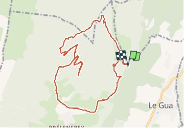
Tour Wandern von 13 km verfügbar auf Auvergne-Rhone-Alpen, Isère, Le Gua. Diese Tour wird von Emelle vorgeschlagen.
Beschreibung
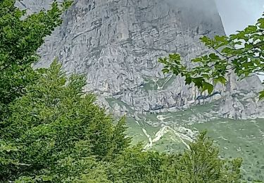
Randonnée sauvage dont une partie du sentier d'accès est hors sentier.
A éviter avec trop de neige (pas loin de 25 cm)
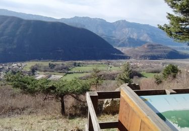
Accès au parking de l'Echaillon par une piste pas toujours en bon état.
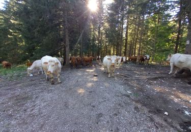
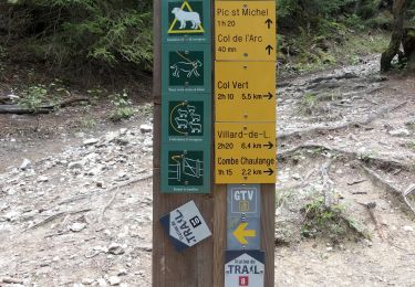
Montée agréable mais soutenue jusqu'aux Vincents, traversée facile jusqu'à ce qu'on quitte la route. Montée dans la neige jusqu'au col de l'Epérimont, puis on remonte plusieurs pistes avant de quitter celles-ci pour rejoindre la crête que l'on remontera à droite jusqu'au sommet.
Descente par le même chemin jusqu'à récupérer une piste puis une autre (modification du terrain avec de nouvelles pistes qui se superposent sur d'anciennes). Le retour à travers la montagne pour éviter le PR qui descend jusqu'au Gros Moran est un chemin privé à éviter, d'autant que la descente sur le versant est est très raide et pas plaisante.
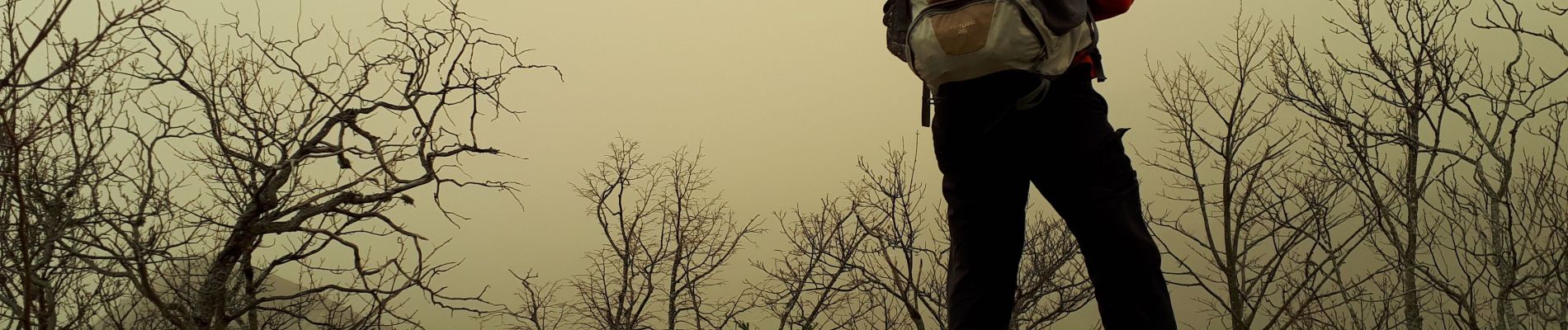
Ce jour-là, un vent de sable en suspension va donner une coloration jaune aux paysages.
Ort
Kommentare
Touren in der Umgebung
![Tour Wandern Château-Bernard - la soldanelle - Photo](https://media.geolcdn.com/t/375/260/75f3f6c9-7fa9-4e53-8263-c310156b3409.jpg&format=jpg&maxdim=2)
![Wandern Wandern](https://static1.geolcdn.com/sitytour/trail-icons/101.png)
Wandern
![](/images/other/stat-length.png)
![](https://static1.geolcdn.com/siteimages/upload/files/16400158638029165_repeat_loop_refresh_sync_direction_icon.png)
![Tour Wandern Villard-de-Lans - Le Plateau du Cornafion 1906m - Photo](https://media.geolcdn.com/t/375/260/ext.jpg?maxdim=2&url=https%3A%2F%2Fservices.sitytrail.com%2FGeolivesWS%2FDownloadMedia.ashx%3FTrailID%3D101491%26Media%3D1596_1.jpg)
![Wandern Wandern](https://static1.geolcdn.com/sitytour/trail-icons/101.png)
Wandern
![](/images/other/stat-length.png)
![](https://static1.geolcdn.com/siteimages/upload/files/16400158638029165_repeat_loop_refresh_sync_direction_icon.png)
![Tour Skiwanderen Villard-de-Lans - Ric du Cornafion et Rocher de l'ours - Photo](https://media.geolcdn.com/t/375/260/8d624654-0068-4609-a37e-9b69fa4aa909.jpg&format=jpg&maxdim=2)
![Skiwanderen Skiwanderen](https://static1.geolcdn.com/sitytour/trail-icons/503.png)
Skiwanderen
![](/images/other/stat-length.png)
![](https://static1.geolcdn.com/siteimages/upload/files/16400158638029165_repeat_loop_refresh_sync_direction_icon.png)
![Tour Wandern Vif - la ferme oriol en circuit - Photo](https://media.geolcdn.com/t/375/260/40456475-f1df-45a6-819a-93e9ddb16412.jpg&format=jpg&maxdim=2)
![Wandern Wandern](https://static1.geolcdn.com/sitytour/trail-icons/101.png)
Wandern
![](/images/other/stat-length.png)
![](https://static1.geolcdn.com/siteimages/upload/files/16400158638029165_repeat_loop_refresh_sync_direction_icon.png)
![Tour Wandern Château-Bernard - tête des chaudières et rocher de la Balme - Photo](https://media.geolcdn.com/t/375/260/0195d12b-3165-4d3f-81a6-2df422d450fa.jpg&format=jpg&maxdim=2)
![Wandern Wandern](https://static1.geolcdn.com/sitytour/trail-icons/101.png)
Wandern
![](/images/other/stat-length.png)
![](https://static1.geolcdn.com/siteimages/upload/files/16400158638029165_repeat_loop_refresh_sync_direction_icon.png)
![Tour Wandern Château-Bernard - sous pas Balme de Arzelier - Photo](https://media.geolcdn.com/t/375/260/ad496dd6-d014-4fff-96cc-8f3a271c17a6.jpg&format=jpg&maxdim=2)
![Wandern Wandern](https://static1.geolcdn.com/sitytour/trail-icons/101.png)
Wandern
![](/images/other/stat-length.png)
![](https://static1.geolcdn.com/siteimages/upload/files/16400158638029165_repeat_loop_refresh_sync_direction_icon.png)
![Tour Wandern Saint-Georges-de-Commiers - Boucle autour de Saint Georges de Commiers - Photo](https://media.geolcdn.com/t/375/260/0bfddc52-e2d2-4332-a925-7e71f6c56a54.jpg&format=jpg&maxdim=2)
![Wandern Wandern](https://static1.geolcdn.com/sitytour/trail-icons/101.png)
Wandern
![](/images/other/stat-length.png)
![](https://static1.geolcdn.com/siteimages/upload/files/16400158638029165_repeat_loop_refresh_sync_direction_icon.png)
![Tour Wandern Villard-de-Lans - Sentier Gobert - Photo](https://media.geolcdn.com/t/375/260/9c9dedef-2f70-4d98-85ae-eb9844091158.jpg&format=jpg&maxdim=2)
![Wandern Wandern](https://static1.geolcdn.com/sitytour/trail-icons/101.png)
Wandern
![](/images/other/stat-length.png)
![](https://static1.geolcdn.com/siteimages/upload/files/16400158638029165_repeat_loop_refresh_sync_direction_icon.png)
![Tour Wandern Villard-de-Lans - Le Pic Saint-Michel (Villard-de-Lans) - Photo](https://media.geolcdn.com/t/375/260/f2a0f31f-0922-425f-b735-5d30e7578f3f.jpg&format=jpg&maxdim=2)
![Wandern Wandern](https://static1.geolcdn.com/sitytour/trail-icons/101.png)
Wandern
![](/images/other/stat-length.png)
![](https://static1.geolcdn.com/siteimages/upload/files/16400158638029165_repeat_loop_refresh_sync_direction_icon.png)