![](/images/other/stat-length.png)
![Tour Schneeschuhwandern Font-Romeu-Odeillo-Via - petit tour au dessus de l'appartement - Photo](https://media.geolcdn.com/t/1900/400/ed6764e8-7284-46bc-b3fa-0a9b813f9d46.jpg&format=pjpeg&maxdim=2)
petit tour au dessus de l'appartement
jpipacific
Benutzer
![Länge](/images/other/stat-length.png)
Länge
6,8 km
![Maximale Höhe](https://static1.geolcdn.com/siteimages/upload/files/1508320355ic_sort_altitude_max_24dp.png)
Maximale Höhe
1877 m
![Positive Höhendifferenz](https://static1.geolcdn.com/siteimages/upload/files/1508320355ic_sort_den_pos_24dp.png)
Positive Höhendifferenz
223 m
![Km-Effort](/images/other/stat-length.png)
Km-Effort
9,7 km
![Min. Höhe](https://static1.geolcdn.com/siteimages/upload/files/1508320355ic_sort_altitude_min_24dp.png)
Min. Höhe
1678 m
![Negative Höhendifferenz](https://static1.geolcdn.com/siteimages/upload/files/1508320355ic_sort_den_neg_24dp.png)
Negative Höhendifferenz
199 m
![Boucle](https://static1.geolcdn.com/siteimages/upload/files/16400158638029165_repeat_loop_refresh_sync_direction_icon.png)
Boucle
Ja
Erstellungsdatum :
2021-02-02 08:37:43.526
Letzte Änderung :
2021-02-02 10:34:53.609
![Schneeschuhwandern](https://static1.geolcdn.com/sitytour/trail-icons/504.png)
1h45
Schwierigkeit : Sehr leicht
![Scannen Sie diesen QR-Code, um die Tour in der SityTrail-Anwendung zu öffnen](https://capi.geolives.com/qq0zvz2zws4bq2lad0pu/sitytour/trails/2658197/qr.png?size=200)
Kostenlosegpshiking-Anwendung
Über SityTrail
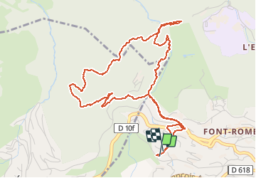
Tour Schneeschuhwandern von 6,8 km verfügbar auf Okzitanien, Ostpyrenäen, Font-Romeu-Odeillo-Via. Diese Tour wird von jpipacific vorgeschlagen.
Beschreibung
Jolie promenade sans difficulté.
Faite le matin. Le sol était de la glace vive. Impossible sans crampon.
Ort
Land:
France
Region :
Okzitanien
Abteilung/Provinz :
Ostpyrenäen
Kommune :
Font-Romeu-Odeillo-Via
Standort:
Unknown
Gehen Sie:(Dec)
Gehen Sie:(UTM)
420547 ; 4706060 (31T) N.
Kommentare
Touren in der Umgebung
![Tour Wandern Font-Romeu-Odeillo-Via - Coll del Pam lac des Bouillouses - Photo](https://media.geolcdn.com/t/375/260/ext.jpg?maxdim=2&url=https%3A%2F%2Fservices.sitytrail.com%2FGeolivesWS%2FDownloadMedia.ashx%3FTrailID%3D802013%26Media%3Dfix__20170803141713.jpg)
![Wandern Wandern](https://static1.geolcdn.com/sitytour/trail-icons/101.png)
Coll del Pam lac des Bouillouses
Wandern
Medium
(2)
Font-Romeu-Odeillo-Via,
Okzitanien,
Ostpyrenäen,
France
![](/images/other/stat-length.png)
13,3 km | 19,3 km-effort
4h 10min
![](https://static1.geolcdn.com/siteimages/upload/files/16400158638029165_repeat_loop_refresh_sync_direction_icon.png)
Ja
![Tour Wandern Eyne - Eyne,col de Nuria,pic d'Eyne,Torre d'Eyne,Eyne. - Photo](https://media.geolcdn.com/t/375/260/ext.jpg?maxdim=2&url=https%3A%2F%2Fservices.sitytrail.com%2FGeolivesWS%2FDownloadMedia.ashx%3FTrailID%3D530520%26Media%3D20150811115220.jpg)
![Wandern Wandern](https://static1.geolcdn.com/sitytour/trail-icons/101.png)
Eyne,col de Nuria,pic d'Eyne,Torre d'Eyne,Eyne.
Wandern
Sehr schwierig
(1)
Eyne,
Okzitanien,
Ostpyrenäen,
France
![](/images/other/stat-length.png)
24 km | 43 km-effort
8h 44min
![](https://static1.geolcdn.com/siteimages/upload/files/16400158638029165_repeat_loop_refresh_sync_direction_icon.png)
Ja
![Tour Schneeschuhwandern Font-Romeu-Odeillo-Via - pic dels moros - Photo](https://media.geolcdn.com/t/375/260/ext.jpg?maxdim=2&url=https%3A%2F%2Fservices.sitytrail.com%2FGeolivesWS%2FDownloadMedia.ashx%3FTrailID%3D509986%26Media%3Dfix__20140323122816.jpg)
![Schneeschuhwandern Schneeschuhwandern](https://static1.geolcdn.com/sitytour/trail-icons/504.png)
pic dels moros
Schneeschuhwandern
Medium
(1)
Font-Romeu-Odeillo-Via,
Okzitanien,
Ostpyrenäen,
France
![](/images/other/stat-length.png)
12,6 km | 19,4 km-effort
4h 46min
![](https://static1.geolcdn.com/siteimages/upload/files/16400158638029165_repeat_loop_refresh_sync_direction_icon.png)
Ja
![Tour Wandern Font-Romeu-Odeillo-Via - Font Romeu Egat - Photo](https://media.geolcdn.com/t/375/260/ext.jpg?maxdim=2&url=https%3A%2F%2Fservices.sitytrail.com%2FGeolivesWS%2FDownloadMedia.ashx%3FTrailID%3D555215%26Media%3D20160418074519.jpg)
![Wandern Wandern](https://static1.geolcdn.com/sitytour/trail-icons/101.png)
Font Romeu Egat
Wandern
Medium
(2)
Font-Romeu-Odeillo-Via,
Okzitanien,
Ostpyrenäen,
France
![](/images/other/stat-length.png)
2,5 km | 3,4 km-effort
44min
![](https://static1.geolcdn.com/siteimages/upload/files/16400158638029165_repeat_loop_refresh_sync_direction_icon.png)
Ja
![Tour Schneeschuhwandern Font-Romeu-Odeillo-Via - Pic dels Moros avec Pierre - Photo](https://media.geolcdn.com/t/375/260/ext.jpg?maxdim=2&url=https%3A%2F%2Fservices.sitytrail.com%2FGeolivesWS%2FDownloadMedia.ashx%3FTrailID%3D542171%26Media%3Dfix__20160322124727.jpg)
![Schneeschuhwandern Schneeschuhwandern](https://static1.geolcdn.com/sitytour/trail-icons/504.png)
Pic dels Moros avec Pierre
Schneeschuhwandern
Medium
(1)
Font-Romeu-Odeillo-Via,
Okzitanien,
Ostpyrenäen,
France
![](/images/other/stat-length.png)
10,5 km | 15,9 km-effort
4h 4min
![](https://static1.geolcdn.com/siteimages/upload/files/16400158638029165_repeat_loop_refresh_sync_direction_icon.png)
Ja
![Tour Wandern Égat - Egat Puig Moro - Photo](https://media.geolcdn.com/t/375/260/ext.jpg?maxdim=2&url=https%3A%2F%2Fservices.sitytrail.com%2FGeolivesWS%2FDownloadMedia.ashx%3FTrailID%3D460362%26Media%3Dfix__20150817141649.jpg)
![Wandern Wandern](https://static1.geolcdn.com/sitytour/trail-icons/101.png)
Egat Puig Moro
Wandern
Medium
(1)
Égat,
Okzitanien,
Ostpyrenäen,
France
![](/images/other/stat-length.png)
13,4 km | 19,3 km-effort
4h 51min
![](https://static1.geolcdn.com/siteimages/upload/files/16400158638029165_repeat_loop_refresh_sync_direction_icon.png)
Ja
![Tour Wandern Égat - La croix d'Egat - Photo](https://media.geolcdn.com/t/375/260/ext.jpg?maxdim=2&url=https%3A%2F%2Fservices.sitytrail.com%2FGeolivesWS%2FDownloadMedia.ashx%3FTrailID%3D143230%26Media%3D20120803102022.jpeg)
![Wandern Wandern](https://static1.geolcdn.com/sitytour/trail-icons/101.png)
La croix d'Egat
Wandern
Einfach
(1)
Égat,
Okzitanien,
Ostpyrenäen,
France
![](/images/other/stat-length.png)
7,1 km | 10,4 km-effort
2h 2min
![](https://static1.geolcdn.com/siteimages/upload/files/16400158638029165_repeat_loop_refresh_sync_direction_icon.png)
Ja
![Tour Wandern Égat - Le Pic dels Moros - Photo](https://media.geolcdn.com/t/375/260/ext.jpg?maxdim=2&url=https%3A%2F%2Fservices.sitytrail.com%2FGeolivesWS%2FDownloadMedia.ashx%3FTrailID%3D108942%26Media%3D2804_1.jpg)
![Wandern Wandern](https://static1.geolcdn.com/sitytour/trail-icons/101.png)
Le Pic dels Moros
Wandern
Schwierig
(2)
Égat,
Okzitanien,
Ostpyrenäen,
France
![](/images/other/stat-length.png)
12,1 km | 18,8 km-effort
5h 30min
![](https://static1.geolcdn.com/siteimages/upload/files/16400158638029165_repeat_loop_refresh_sync_direction_icon.png)
Ja
![Tour Mountainbike Font-Romeu-Odeillo-Via - Espace VTT FFC Pyrénées Catalanes - Circuit n° 6 - Forêt d'Egat - Photo](https://media.geolcdn.com/t/375/260/ext.jpg?maxdim=2&url=https%3A%2F%2Fservices.sitytrail.com%2FGeolivesWS%2FDownloadMedia.ashx%3FTrailID%3D102104%26Media%3D2487_1.jpg)
![Mountainbike Mountainbike](https://static1.geolcdn.com/sitytour/trail-icons/202.png)
Espace VTT FFC Pyrénées Catalanes - Circuit n° 6 - Forêt d'Egat
Mountainbike
Medium
(2)
Font-Romeu-Odeillo-Via,
Okzitanien,
Ostpyrenäen,
France
![](/images/other/stat-length.png)
7,6 km | 10,1 km-effort
1h 0min
![](https://static1.geolcdn.com/siteimages/upload/files/16400158638029165_repeat_loop_refresh_sync_direction_icon.png)
Ja