![](/images/other/stat-length.png)
![Tour Wandern Roiffieux - Roiffieux , St Romain, St Alban d'Ay - Photo](https://media.geolcdn.com/t/1900/400/ext.pjpeg?maxdim=2&url=https%3A%2F%2Fstatic1.geolcdn.com%2Fsiteimages%2Fupload%2Ffiles%2F1553511878bg_sport_marche.png)
Roiffieux , St Romain, St Alban d'Ay
tartane1
Benutzer
![Länge](/images/other/stat-length.png)
Länge
11,8 km
![Maximale Höhe](https://static1.geolcdn.com/siteimages/upload/files/1508320355ic_sort_altitude_max_24dp.png)
Maximale Höhe
490 m
![Positive Höhendifferenz](https://static1.geolcdn.com/siteimages/upload/files/1508320355ic_sort_den_pos_24dp.png)
Positive Höhendifferenz
179 m
![Km-Effort](/images/other/stat-length.png)
Km-Effort
14,2 km
![Min. Höhe](https://static1.geolcdn.com/siteimages/upload/files/1508320355ic_sort_altitude_min_24dp.png)
Min. Höhe
379 m
![Negative Höhendifferenz](https://static1.geolcdn.com/siteimages/upload/files/1508320355ic_sort_den_neg_24dp.png)
Negative Höhendifferenz
182 m
![Boucle](https://static1.geolcdn.com/siteimages/upload/files/16400158638029165_repeat_loop_refresh_sync_direction_icon.png)
Boucle
Ja
Erstellungsdatum :
2021-01-24 12:33:51.647
Letzte Änderung :
2021-01-24 18:24:40.661
![Wandern](https://static1.geolcdn.com/sitytour/trail-icons/101.png)
2h44
Schwierigkeit : Einfach
![Scannen Sie diesen QR-Code, um die Tour in der SityTrail-Anwendung zu öffnen](https://capi.geolives.com/qq0zvz2zws4bq2lad0pu/sitytour/trails/2649894/qr.png?size=200)
Kostenlosegpshiking-Anwendung
Über SityTrail
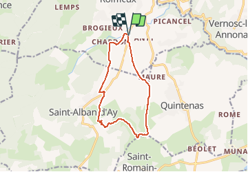
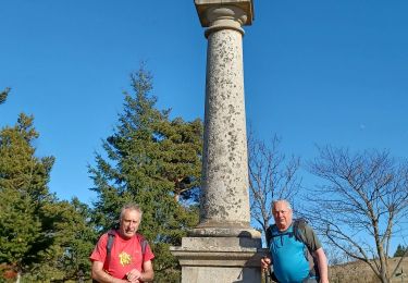
Tour Wandern von 11,8 km verfügbar auf Auvergne-Rhone-Alpen, Ardèche, Roiffieux. Diese Tour wird von tartane1 vorgeschlagen.
Beschreibung
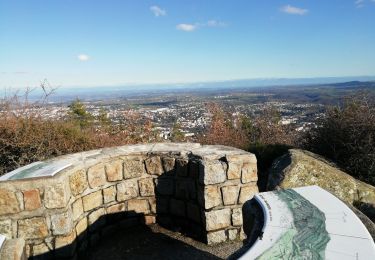
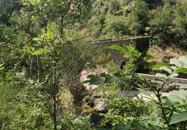
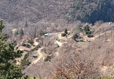
Parcours champêtre. Beau point de vue su la chaîne des Alpes et le Mont Blanc, par temps clair.
Départ du lieu-dit Les Cluzeaux à Roiffieux (07)
Ort
Land:
France
Region :
Auvergne-Rhone-Alpen
Abteilung/Provinz :
Ardèche
Kommune :
Roiffieux
Standort:
Unknown
Gehen Sie:(Dec)
Gehen Sie:(UTM)
630386 ; 5008072 (31T) N.
Kommentare
Touren in der Umgebung
![Tour Wandern Annonay - 07 Chatinay Montmiandon 3km 130m - Photo](https://media.geolcdn.com/t/375/260/38c72199-7cbc-4cd0-a9e5-aa7227a3ce77.jpg&format=jpg&maxdim=2)
![Wandern Wandern](https://static1.geolcdn.com/sitytour/trail-icons/101.png)
07 Chatinay Montmiandon 3km 130m
Wandern
Sehr leicht
(2)
Annonay,
Auvergne-Rhone-Alpen,
Ardèche,
France
![](/images/other/stat-length.png)
3 km | 4,8 km-effort
55min
![](https://static1.geolcdn.com/siteimages/upload/files/16400158638029165_repeat_loop_refresh_sync_direction_icon.png)
Ja
![Tour Wandern Villevocance - 07 mer de glace Cx chirols - Photo](https://media.geolcdn.com/t/375/260/650c9d29-4730-4be0-bed1-27c07fa096d1.jpg&format=jpg&maxdim=2)
![Wandern Wandern](https://static1.geolcdn.com/sitytour/trail-icons/101.png)
07 mer de glace Cx chirols
Wandern
Medium
Villevocance,
Auvergne-Rhone-Alpen,
Ardèche,
France
![](/images/other/stat-length.png)
14,8 km | 23 km-effort
6h 5min
![](https://static1.geolcdn.com/siteimages/upload/files/16400158638029165_repeat_loop_refresh_sync_direction_icon.png)
Ja
![Tour sport Vernosc-lès-Annonay - Les passerelles de la Cance Vernosc - Photo](https://media.geolcdn.com/t/375/260/ae3ac81d-f44c-4292-b688-0cdbe25cdc15.jpg&format=jpg&maxdim=2)
Les passerelles de la Cance Vernosc
sport
Sehr leicht
Vernosc-lès-Annonay,
Auvergne-Rhone-Alpen,
Ardèche,
France
![](/images/other/stat-length.png)
10,5 km | 15,2 km-effort
Unbekannt
![](https://static1.geolcdn.com/siteimages/upload/files/16400158638029165_repeat_loop_refresh_sync_direction_icon.png)
Ja
![Tour Laufen Quintenas - roche Péréandre, pont suspendu circuit - Photo](https://media.geolcdn.com/t/375/260/1ca2ef30-37ec-41a5-8885-fe3e88c20bbf.jpg&format=jpg&maxdim=2)
![Laufen Laufen](https://static1.geolcdn.com/sitytour/trail-icons/103.png)
roche Péréandre, pont suspendu circuit
Laufen
Medium
Quintenas,
Auvergne-Rhone-Alpen,
Ardèche,
France
![](/images/other/stat-length.png)
11,6 km | 16,1 km-effort
1h 35min
![](https://static1.geolcdn.com/siteimages/upload/files/16400158638029165_repeat_loop_refresh_sync_direction_icon.png)
Ja
![Tour Wandern Villevocance - la Mer de glace - Photo](https://media.geolcdn.com/t/375/260/fa8631d6-f8e5-4999-b914-4f21f7ed2db5.jpg&format=jpg&maxdim=2)
![Wandern Wandern](https://static1.geolcdn.com/sitytour/trail-icons/101.png)
la Mer de glace
Wandern
Schwierig
Villevocance,
Auvergne-Rhone-Alpen,
Ardèche,
France
![](/images/other/stat-length.png)
11,9 km | 18,3 km-effort
6h 20min
![](https://static1.geolcdn.com/siteimages/upload/files/16400158638029165_repeat_loop_refresh_sync_direction_icon.png)
Ja
![Tour Rennrad Annonay - 07 Annonay Chambon sur lignon 11 - Photo](https://media.geolcdn.com/t/375/260/ext.jpg?maxdim=2&url=https%3A%2F%2Fstatic1.geolcdn.com%2Fsiteimages%2Fupload%2Ffiles%2F1524743154velo.jpg)
![Rennrad Rennrad](https://static1.geolcdn.com/sitytour/trail-icons/201.png)
07 Annonay Chambon sur lignon 11
Rennrad
Schwierig
Annonay,
Auvergne-Rhone-Alpen,
Ardèche,
France
![](/images/other/stat-length.png)
70 km | 94 km-effort
7h 40min
![](https://static1.geolcdn.com/siteimages/upload/files/16400158638029165_repeat_loop_refresh_sync_direction_icon.png)
Nein
![Tour Wandern Villevocance - croix de chirol - Photo](https://media.geolcdn.com/t/375/260/c128a409-2694-440b-a521-434765b7b550.jpg&format=jpg&maxdim=2)
![Wandern Wandern](https://static1.geolcdn.com/sitytour/trail-icons/101.png)
croix de chirol
Wandern
Sehr schwierig
Villevocance,
Auvergne-Rhone-Alpen,
Ardèche,
France
![](/images/other/stat-length.png)
17,7 km | 27 km-effort
7h 4min
![](https://static1.geolcdn.com/siteimages/upload/files/16400158638029165_repeat_loop_refresh_sync_direction_icon.png)
Ja
![Tour Rennrad Annonay - 07 Annonay Chambon sur lignon - Photo](https://media.geolcdn.com/t/375/260/ext.jpg?maxdim=2&url=https%3A%2F%2Fstatic1.geolcdn.com%2Fsiteimages%2Fupload%2Ffiles%2F1524743154velo.jpg)
![Rennrad Rennrad](https://static1.geolcdn.com/sitytour/trail-icons/201.png)
07 Annonay Chambon sur lignon
Rennrad
Schwierig
Annonay,
Auvergne-Rhone-Alpen,
Ardèche,
France
![](/images/other/stat-length.png)
70 km | 94 km-effort
7h 40min
![](https://static1.geolcdn.com/siteimages/upload/files/16400158638029165_repeat_loop_refresh_sync_direction_icon.png)
Nein
![Tour Wandern Villevocance - 07 cc chirol 2020 - Photo](https://media.geolcdn.com/t/375/260/ext.jpg?maxdim=2&url=https%3A%2F%2Fstatic1.geolcdn.com%2Fsiteimages%2Fupload%2Ffiles%2F1553511878bg_sport_marche.png)
![Wandern Wandern](https://static1.geolcdn.com/sitytour/trail-icons/101.png)
07 cc chirol 2020
Wandern
Medium
Villevocance,
Auvergne-Rhone-Alpen,
Ardèche,
France
![](/images/other/stat-length.png)
15,5 km | 24 km-effort
4h 12min
![](https://static1.geolcdn.com/siteimages/upload/files/16400158638029165_repeat_loop_refresh_sync_direction_icon.png)
Nein