![](/images/other/stat-length.png)
![Tour Laufen Ville-di-Pietrabugno - Mare et Mare Bastia Olmetu - Photo](https://media.geolcdn.com/t/1900/400/ext.pjpeg?maxdim=2&url=https%3A%2F%2Fservices.sitytrail.com%2FGeolivesWS%2FDownloadMedia.ashx%3FTrailID%3D264199%26Media%3Dfix__20140406100156.jpg)
Mare et Mare Bastia Olmetu
Bruno.febvre
Benutzer
![Länge](/images/other/stat-length.png)
![Maximale Höhe](https://static1.geolcdn.com/siteimages/upload/files/1508320355ic_sort_altitude_max_24dp.png)
![Positive Höhendifferenz](https://static1.geolcdn.com/siteimages/upload/files/1508320355ic_sort_den_pos_24dp.png)
![Km-Effort](/images/other/stat-length.png)
![Min. Höhe](https://static1.geolcdn.com/siteimages/upload/files/1508320355ic_sort_altitude_min_24dp.png)
![Negative Höhendifferenz](https://static1.geolcdn.com/siteimages/upload/files/1508320355ic_sort_den_neg_24dp.png)
![Boucle](https://static1.geolcdn.com/siteimages/upload/files/16400158638029165_repeat_loop_refresh_sync_direction_icon.png)
![Laufen](https://static1.geolcdn.com/sitytour/trail-icons/103.png)
5h30
Schwierigkeit : Sehr schwierig
![Scannen Sie diesen QR-Code, um die Tour in der SityTrail-Anwendung zu öffnen](https://capi.geolives.com/qq0zvz2zws4bq2lad0pu/sitytour/trails/264199/qr.png?size=200)
Kostenlosegpshiking-Anwendung
Über SityTrail
Tour Laufen von 34 km verfügbar auf Korsika, Haute-Corse, Ville-di-Pietrabugno. Diese Tour wird von Bruno.febvre vorgeschlagen.
Beschreibung
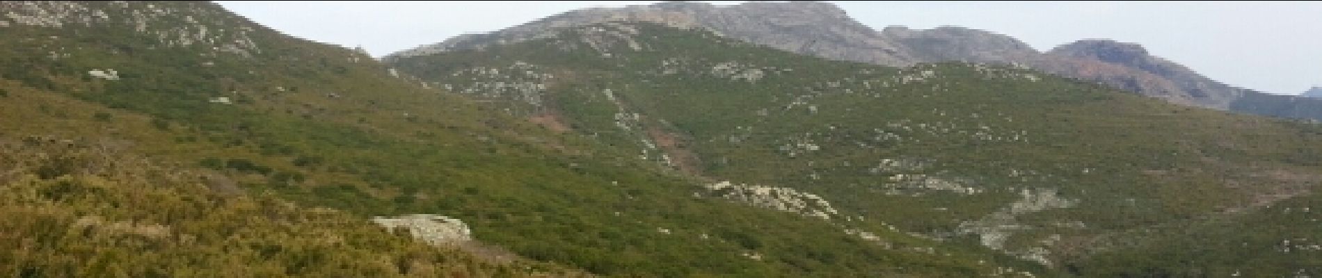
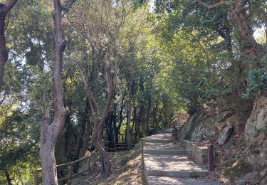
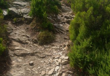
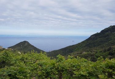
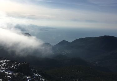
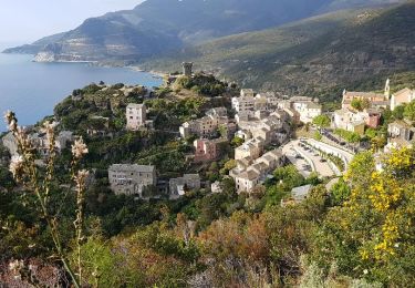
Un superbe parcours en A-R !!! L idée depuis Bastia rejoindre la côte ouest puis revenir. Ceci afin de voir et toucher la mer des deux côtés de l'île. Une traversée par le pouce réalisable à la journée... Au départ du port de Bastia rejoindre le sentier Guaitella ( Pietrabugno) qui part en haut du lotissement du Toga. On traverse le très beau village d'Alzetu en pierre et Guaitella avec son lavoir ... Ensuite commence la montée vers le Bocca di San Léonardo. Bien suivre le marquage jaune et rouge puis rouge seulement. Le sentier est bon et agréable. Ensuite c'est beaucoup plus minéral et sauvage vers San Jacintu. Puis une descente plutôt technique vers Poggio. A la sortie du village vers le cimetière suivre le sentier en balcon jusqu'à la mer...et la tour de Négru !!! Il reste à rentrer maintenant. Bon courage
Ort
Kommentare
Touren in der Umgebung
![Tour Andere Aktivitäten Ville-di-Pietrabugno - Guaitella-bocca St Lucia - Photo](https://media.geolcdn.com/t/375/260/ext.jpg?maxdim=2&url=https%3A%2F%2Fstatic1.geolcdn.com%2Fsiteimages%2Fupload%2Ffiles%2F1545311037marcheuse_200dpi.jpg)
![Andere Aktivitäten Andere Aktivitäten](https://static1.geolcdn.com/sitytour/trail-icons/900.png)
Andere Aktivitäten
![](/images/other/stat-length.png)
![](https://static1.geolcdn.com/siteimages/upload/files/16400158638029165_repeat_loop_refresh_sync_direction_icon.png)
![Tour Wandern Bastia - Autour de Cardo - Photo](https://media.geolcdn.com/t/375/260/a81ea43c-17ba-4f4f-b50d-d5008c6f897c.jpg&format=jpg&maxdim=2)
![Wandern Wandern](https://static1.geolcdn.com/sitytour/trail-icons/101.png)
Wandern
![](/images/other/stat-length.png)
![](https://static1.geolcdn.com/siteimages/upload/files/16400158638029165_repeat_loop_refresh_sync_direction_icon.png)
![Tour Wandern Bastia - visite Bastia centre - Photo](https://media.geolcdn.com/t/375/260/032d0ed4-0b93-4b76-95cc-777057c702da.jpg&format=jpg&maxdim=2)
![Wandern Wandern](https://static1.geolcdn.com/sitytour/trail-icons/101.png)
Wandern
![](/images/other/stat-length.png)
![](https://static1.geolcdn.com/siteimages/upload/files/16400158638029165_repeat_loop_refresh_sync_direction_icon.png)
![Tour Pfad Ville-di-Pietrabugno - Cima di Gratera - Photo](https://media.geolcdn.com/t/375/260/8d3c9239-5de0-4068-97be-2cb56efcf2e7.jpg&format=jpg&maxdim=2)
![Pfad Pfad](https://static1.geolcdn.com/sitytour/trail-icons/104.png)
Pfad
![](/images/other/stat-length.png)
![](https://static1.geolcdn.com/siteimages/upload/files/16400158638029165_repeat_loop_refresh_sync_direction_icon.png)
![Tour Wandern Bastia - Cardo - Photo](https://media.geolcdn.com/t/375/260/7a9f2b4d-d59b-404c-83cf-9e9d8d1a369d.jpg&format=jpg&maxdim=2)
![Wandern Wandern](https://static1.geolcdn.com/sitytour/trail-icons/101.png)
![Tour Wandern Bastia - chemin des crêtes au dessus de Bastia - Photo](https://media.geolcdn.com/t/375/260/39ee6f56-44c9-46b1-8cd4-b40cef70ad5f.jpg&format=jpg&maxdim=2)
![Wandern Wandern](https://static1.geolcdn.com/sitytour/trail-icons/101.png)
Wandern
![](/images/other/stat-length.png)
![](https://static1.geolcdn.com/siteimages/upload/files/16400158638029165_repeat_loop_refresh_sync_direction_icon.png)
![Tour Wandern Bastia - CapCorse0 - Photo](https://media.geolcdn.com/t/375/260/ext.jpg?maxdim=2&url=https%3A%2F%2Fservices.sitytrail.com%2FGeolivesWS%2FDownloadMedia.ashx%3FTrailID%3D718281%26Media%3D82de1827-d35f-42b5-ada9-004093c435a2.jpg)
![Wandern Wandern](https://static1.geolcdn.com/sitytour/trail-icons/101.png)
Wandern
![](/images/other/stat-length.png)
![](https://static1.geolcdn.com/siteimages/upload/files/16400158638029165_repeat_loop_refresh_sync_direction_icon.png)
![Tour Andere Aktivitäten Santa-Maria-di-Lota - Chapelle St jean monte cimone monte Stellu - Photo](https://media.geolcdn.com/t/375/260/ext.jpg?maxdim=2&url=https%3A%2F%2Fservices.sitytrail.com%2FGeolivesWS%2FDownloadMedia.ashx%3FTrailID%3D697286%26Media%3D20170211154101.jpg)
![Andere Aktivitäten Andere Aktivitäten](https://static1.geolcdn.com/sitytour/trail-icons/900.png)
Andere Aktivitäten
![](/images/other/stat-length.png)
![](https://static1.geolcdn.com/siteimages/upload/files/16400158638029165_repeat_loop_refresh_sync_direction_icon.png)
![Tour Wandern San-Martino-di-Lota - CapCorse1 - Photo](https://media.geolcdn.com/t/375/260/ext.jpg?maxdim=2&url=https%3A%2F%2Fservices.sitytrail.com%2FGeolivesWS%2FDownloadMedia.ashx%3FTrailID%3D683766%26Media%3D1296c19e-72cb-4d33-b9b7-fba403e380ef.jpg)
![Wandern Wandern](https://static1.geolcdn.com/sitytour/trail-icons/101.png)
Wandern
![](/images/other/stat-length.png)
![](https://static1.geolcdn.com/siteimages/upload/files/16400158638029165_repeat_loop_refresh_sync_direction_icon.png)