![](/images/other/stat-length.png)
![Tour Wandern Vuren - Ulvend - Photo](https://media.geolcdn.com/t/1900/400/a8f38e9f-6701-4e87-b56e-6b495cbcf17b.jpg&format=pjpeg&maxdim=2)
Ulvend
mumu.larandonneuse
Benutzer GUIDE
![Länge](/images/other/stat-length.png)
Länge
11,4 km
![Maximale Höhe](https://static1.geolcdn.com/siteimages/upload/files/1508320355ic_sort_altitude_max_24dp.png)
Maximale Höhe
220 m
![Positive Höhendifferenz](https://static1.geolcdn.com/siteimages/upload/files/1508320355ic_sort_den_pos_24dp.png)
Positive Höhendifferenz
201 m
![Km-Effort](/images/other/stat-length.png)
Km-Effort
14,1 km
![Min. Höhe](https://static1.geolcdn.com/siteimages/upload/files/1508320355ic_sort_altitude_min_24dp.png)
Min. Höhe
112 m
![Negative Höhendifferenz](https://static1.geolcdn.com/siteimages/upload/files/1508320355ic_sort_den_neg_24dp.png)
Negative Höhendifferenz
203 m
![Boucle](https://static1.geolcdn.com/siteimages/upload/files/16400158638029165_repeat_loop_refresh_sync_direction_icon.png)
Boucle
Ja
Erstellungsdatum :
2021-01-01 11:27:42.798
Letzte Änderung :
2021-01-01 20:22:46.97
![Wandern](https://static1.geolcdn.com/sitytour/trail-icons/101.png)
2h29
Schwierigkeit : Einfach
![Scannen Sie diesen QR-Code, um die Tour in der SityTrail-Anwendung zu öffnen](https://capi.geolives.com/qq0zvz2zws4bq2lad0pu/sitytour/trails/2629801/qr.png?size=200)
Kostenlosegpshiking-Anwendung
Über SityTrail
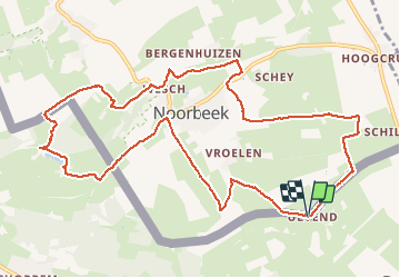
Tour Wandern von 11,4 km verfügbar auf Flandern, Limburg, Vuren. Diese Tour wird von mumu.larandonneuse vorgeschlagen.
Beschreibung
Superbe parcours transfrontalier entre 🇧🇪 et 🇾🇪.
📌 Glacier 't Bakhuis, Ulvend 3 à Fourons-St-Martin.
➡️📄 www.wandelgidszuidlimburg.com/routes-es-francais n° 1293.
Ort
Land:
Belgium
Region :
Flandern
Abteilung/Provinz :
Limburg
Kommune :
Vuren
Standort:
Sint-Martens-Voeren
Gehen Sie:(Dec)
Gehen Sie:(UTM)
699614 ; 5626790 (31U) N.
Kommentare
Touren in der Umgebung
![Tour Wandern Eijsden-Margraten - 2024-07-15_17h32m47_eijsden-margraten-mh1-altenbroek - Photo](https://media.geolcdn.com/t/375/260/1dd6d074-f00f-48cf-a4e6-d95117778ebf.jpg&format=jpg&maxdim=2)
![Wandern Wandern](https://static1.geolcdn.com/sitytour/trail-icons/101.png)
2024-07-15_17h32m47_eijsden-margraten-mh1-altenbroek
Wandern
Medium
(1)
Eijsden-Margraten,
Limburg,
Unbekannt,
Netherlands
![](/images/other/stat-length.png)
8,8 km | 11 km-effort
2h 29min
![](https://static1.geolcdn.com/siteimages/upload/files/16400158638029165_repeat_loop_refresh_sync_direction_icon.png)
Ja
![Tour Wandern Eijsden-Margraten - Mheer - Banholt - Hoogbos - Photo](https://media.geolcdn.com/t/375/260/1f70cdf1-9a0b-4d25-acc7-7c75993bbb86.jpg&format=jpg&maxdim=2)
![Wandern Wandern](https://static1.geolcdn.com/sitytour/trail-icons/101.png)
Mheer - Banholt - Hoogbos
Wandern
Medium
(1)
Eijsden-Margraten,
Limburg,
Unbekannt,
Netherlands
![](/images/other/stat-length.png)
12,5 km | 14,5 km-effort
3h 4min
![](https://static1.geolcdn.com/siteimages/upload/files/16400158638029165_repeat_loop_refresh_sync_direction_icon.png)
Ja
![Tour Wandern Vuren - Amstel Gold Race 2024 🚲 - Photo](https://media.geolcdn.com/t/375/260/bca146f7-0c03-4970-a3ca-ea328283e994.jpg&format=jpg&maxdim=2)
![Wandern Wandern](https://static1.geolcdn.com/sitytour/trail-icons/101.png)
Amstel Gold Race 2024 🚲
Wandern
Medium
(1)
Vuren,
Flandern,
Limburg,
Belgium
![](/images/other/stat-length.png)
11,7 km | 14,9 km-effort
3h 23min
![](https://static1.geolcdn.com/siteimages/upload/files/16400158638029165_repeat_loop_refresh_sync_direction_icon.png)
Ja
![Tour Wandern Vuren - Ulvend - La Planck - Noorbeek - Photo](https://media.geolcdn.com/t/375/260/1b8a3af4-c436-4943-b8e2-3197209c6144.jpg&format=jpg&maxdim=2)
![Wandern Wandern](https://static1.geolcdn.com/sitytour/trail-icons/101.png)
Ulvend - La Planck - Noorbeek
Wandern
Einfach
(1)
Vuren,
Flandern,
Limburg,
Belgium
![](/images/other/stat-length.png)
17 km | 22 km-effort
4h 57min
![](https://static1.geolcdn.com/siteimages/upload/files/16400158638029165_repeat_loop_refresh_sync_direction_icon.png)
Ja
![Tour Wandern Vuren - 2022-11-11_17h35m36_wandelroute-de-voerstreek-mooiste - Photo](https://media.geolcdn.com/t/375/260/3df743f8-88e4-4c10-a47a-c05fdf0072fe.jpg&format=jpg&maxdim=2)
![Wandern Wandern](https://static1.geolcdn.com/sitytour/trail-icons/101.png)
2022-11-11_17h35m36_wandelroute-de-voerstreek-mooiste
Wandern
Medium
(1)
Vuren,
Flandern,
Limburg,
Belgium
![](/images/other/stat-length.png)
9,3 km | 12,5 km-effort
2h 49min
![](https://static1.geolcdn.com/siteimages/upload/files/16400158638029165_repeat_loop_refresh_sync_direction_icon.png)
Ja
![Tour Wandern Vuren - La Commanderie 7 - Photo](https://media.geolcdn.com/t/375/260/e2b67305-0779-4cca-9070-82e3402cc790.jpg&format=jpg&maxdim=2)
![Wandern Wandern](https://static1.geolcdn.com/sitytour/trail-icons/101.png)
La Commanderie 7
Wandern
Einfach
(1)
Vuren,
Flandern,
Limburg,
Belgium
![](/images/other/stat-length.png)
4,5 km | 6,3 km-effort
1h 26min
![](https://static1.geolcdn.com/siteimages/upload/files/16400158638029165_repeat_loop_refresh_sync_direction_icon.png)
Ja
![Tour Wandern Dalhem - 2021-10-21_18h00m54_1397 - Photo](https://media.geolcdn.com/t/375/260/9e5bb66b-83f0-45b1-bd6f-be4253f11322.jpg&format=jpg&maxdim=2)
![Wandern Wandern](https://static1.geolcdn.com/sitytour/trail-icons/101.png)
2021-10-21_18h00m54_1397
Wandern
Medium
(2)
Dalhem,
Wallonien,
Lüttich,
Belgium
![](/images/other/stat-length.png)
13,9 km | 17,6 km-effort
3h 59min
![](https://static1.geolcdn.com/siteimages/upload/files/16400158638029165_repeat_loop_refresh_sync_direction_icon.png)
Ja
![Tour Wandern Vuren - 2021-10-13_17h01m13_fouron-le-comte - Photo](https://media.geolcdn.com/t/375/260/e05bdacf-e910-4818-b0aa-de5529cdf1e8.jpg&format=jpg&maxdim=2)
![Wandern Wandern](https://static1.geolcdn.com/sitytour/trail-icons/101.png)
2021-10-13_17h01m13_fouron-le-comte
Wandern
Einfach
(1)
Vuren,
Flandern,
Limburg,
Belgium
![](/images/other/stat-length.png)
14,5 km | 16,9 km-effort
3h 50min
![](https://static1.geolcdn.com/siteimages/upload/files/16400158638029165_repeat_loop_refresh_sync_direction_icon.png)
Ja
![Tour Wandern Eijsden-Margraten - 2021-06-19_19h26m43_031 - Photo](https://media.geolcdn.com/t/375/260/136c3226-85ca-4638-b449-da2a119d703c.jpg&format=jpg&maxdim=2)
![Wandern Wandern](https://static1.geolcdn.com/sitytour/trail-icons/101.png)
2021-06-19_19h26m43_031
Wandern
Einfach
(1)
Eijsden-Margraten,
Limburg,
Unbekannt,
Netherlands
![](/images/other/stat-length.png)
13,3 km | 15,7 km-effort
3h 34min
![](https://static1.geolcdn.com/siteimages/upload/files/16400158638029165_repeat_loop_refresh_sync_direction_icon.png)
Ja