![](/images/other/stat-length.png)
![Tour Wandern Aix-les-Bains - 20201226 la Chambotte - Photo](https://media.geolcdn.com/t/1900/400/cefcbb18-a552-47f8-b6b9-bdd733b67150.jpg&format=pjpeg&maxdim=2)
20201226 la Chambotte
BobJanssen
Benutzer
![Länge](/images/other/stat-length.png)
Länge
31 km
![Maximale Höhe](https://static1.geolcdn.com/siteimages/upload/files/1508320355ic_sort_altitude_max_24dp.png)
Maximale Höhe
845 m
![Positive Höhendifferenz](https://static1.geolcdn.com/siteimages/upload/files/1508320355ic_sort_den_pos_24dp.png)
Positive Höhendifferenz
1036 m
![Km-Effort](/images/other/stat-length.png)
Km-Effort
45 km
![Min. Höhe](https://static1.geolcdn.com/siteimages/upload/files/1508320355ic_sort_altitude_min_24dp.png)
Min. Höhe
230 m
![Negative Höhendifferenz](https://static1.geolcdn.com/siteimages/upload/files/1508320355ic_sort_den_neg_24dp.png)
Negative Höhendifferenz
1036 m
![Boucle](https://static1.geolcdn.com/siteimages/upload/files/16400158638029165_repeat_loop_refresh_sync_direction_icon.png)
Boucle
Ja
Erstellungsdatum :
2020-12-26 08:20:17.859
Letzte Änderung :
2020-12-26 17:44:18.241
![Wandern](https://static1.geolcdn.com/sitytour/trail-icons/101.png)
8h39
Schwierigkeit : Schwierig
![Scannen Sie diesen QR-Code, um die Tour in der SityTrail-Anwendung zu öffnen](https://capi.geolives.com/qq0zvz2zws4bq2lad0pu/sitytour/trails/2625876/qr.png?size=200)
Kostenlosegpshiking-Anwendung
Über SityTrail
Tour Wandern von 31 km verfügbar auf Auvergne-Rhone-Alpen, Savoyen, Aix-les-Bains. Diese Tour wird von BobJanssen vorgeschlagen.
Beschreibung
Pt pt memard sarde cotefort taramont unik mairie combes Granges Chambotte Cx de Meyrieu Combes taramont cotefort sarde memard pt pt
Ort
Land:
France
Region :
Auvergne-Rhone-Alpen
Abteilung/Provinz :
Savoyen
Kommune :
Aix-les-Bains
Standort:
Unknown
Gehen Sie:(Dec)
Gehen Sie:(UTM)
725230 ; 5064055 (31T) N.
Kommentare
Touren in der Umgebung
![Tour Wandern Brison-Saint-Innocent - La Croix de Meyrieu, retour par la Grotte des Fées, depuis les Combes - Photo](https://media.geolcdn.com/t/375/260/ext.jpg?maxdim=2&url=https%3A%2F%2Fservices.sitytrail.com%2FGeolivesWS%2FDownloadMedia.ashx%3FTrailID%3D317495%26Media%3D16730_1.jpg)
![Wandern Wandern](https://static1.geolcdn.com/sitytour/trail-icons/101.png)
La Croix de Meyrieu, retour par la Grotte des Fées, depuis les Combes
Wandern
Einfach
(2)
Brison-Saint-Innocent,
Auvergne-Rhone-Alpen,
Savoyen,
France
![](/images/other/stat-length.png)
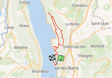
8,5 km | 14,8 km-effort
3h 30min
![](https://static1.geolcdn.com/siteimages/upload/files/16400158638029165_repeat_loop_refresh_sync_direction_icon.png)
Ja
![Tour Mountainbike Aix-les-Bains - Randolac 2008 - Epine Chat Chambotte - Photo](https://media.geolcdn.com/t/375/260/ext.jpg?maxdim=2&url=https%3A%2F%2Fservices.sitytrail.com%2FGeolivesWS%2FDownloadMedia.ashx%3FTrailID%3D102831%26Media%3D3994_2.jpg)
![Mountainbike Mountainbike](https://static1.geolcdn.com/sitytour/trail-icons/202.png)
Randolac 2008 - Epine Chat Chambotte
Mountainbike
Sehr schwierig
(1)
Aix-les-Bains,
Auvergne-Rhone-Alpen,
Savoyen,
France
![](/images/other/stat-length.png)
64 km | 94 km-effort
7h 0min
![](https://static1.geolcdn.com/siteimages/upload/files/16400158638029165_repeat_loop_refresh_sync_direction_icon.png)
Ja
![Tour Wandern Le Bourget-du-Lac - La Dent du Chat 1390m, le Molard Noir 1452m - Photo](https://media.geolcdn.com/t/375/260/ext.jpg?maxdim=2&url=https%3A%2F%2Fservices.sitytrail.com%2FGeolivesWS%2FDownloadMedia.ashx%3FTrailID%3D102504%26Media%3D3313_1.jpg)
![Wandern Wandern](https://static1.geolcdn.com/sitytour/trail-icons/101.png)
La Dent du Chat 1390m, le Molard Noir 1452m
Wandern
Schwierig
(4)
Le Bourget-du-Lac,
Auvergne-Rhone-Alpen,
Savoyen,
France
![](/images/other/stat-length.png)
6,6 km | 13,7 km-effort
3h 30min
![](https://static1.geolcdn.com/siteimages/upload/files/16400158638029165_repeat_loop_refresh_sync_direction_icon.png)
Ja
![Tour Wandern Brison-Saint-Innocent - Grotte des fées, Croix de Meyrieu, Mont Corsuet 843m 1.7.24 - Photo](https://media.geolcdn.com/t/375/260/40c03b1e-7ecc-48c9-b0a4-5c8c250e48e1.jpg&format=jpg&maxdim=2)
![Wandern Wandern](https://static1.geolcdn.com/sitytour/trail-icons/101.png)
Grotte des fées, Croix de Meyrieu, Mont Corsuet 843m 1.7.24
Wandern
Medium
Brison-Saint-Innocent,
Auvergne-Rhone-Alpen,
Savoyen,
France
![](/images/other/stat-length.png)
13,5 km | 22 km-effort
4h 30min
![](https://static1.geolcdn.com/siteimages/upload/files/16400158638029165_repeat_loop_refresh_sync_direction_icon.png)
Ja
![Tour Elektrofahrrad Aix-les-Bains - Aix les bains tour lac de Bourget abbaye Hautecombes - Photo](https://media.geolcdn.com/t/375/260/6de4fae3-0815-4d48-bb94-d895cfa7b1bb.jpg&format=jpg&maxdim=2)
![Elektrofahrrad Elektrofahrrad](https://static1.geolcdn.com/sitytour/trail-icons/205.png)
Aix les bains tour lac de Bourget abbaye Hautecombes
Elektrofahrrad
Medium
Aix-les-Bains,
Auvergne-Rhone-Alpen,
Savoyen,
France
![](/images/other/stat-length.png)
66 km | 85 km-effort
5h 8min
![](https://static1.geolcdn.com/siteimages/upload/files/16400158638029165_repeat_loop_refresh_sync_direction_icon.png)
Ja
![Tour Wandern Mouxy - Sentier du Perthuiset - Photo](https://media.geolcdn.com/t/375/260/ext.jpg?maxdim=2&url=https%3A%2F%2Fstatic1.geolcdn.com%2Fsiteimages%2Fupload%2Ffiles%2F1553511878bg_sport_marche.png)
![Wandern Wandern](https://static1.geolcdn.com/sitytour/trail-icons/101.png)
Sentier du Perthuiset
Wandern
Medium
(1)
Mouxy,
Auvergne-Rhone-Alpen,
Savoyen,
France
![](/images/other/stat-length.png)
9,4 km | 19,9 km-effort
3h 19min
![](https://static1.geolcdn.com/siteimages/upload/files/16400158638029165_repeat_loop_refresh_sync_direction_icon.png)
Ja
![Tour Wandern Saint-Jean-de-Chevelu - La dent du chat - Photo](https://media.geolcdn.com/t/375/260/ext.jpg?maxdim=2&url=https%3A%2F%2Fstatic1.geolcdn.com%2Fsiteimages%2Fupload%2Ffiles%2F1553511878bg_sport_marche.png)
![Wandern Wandern](https://static1.geolcdn.com/sitytour/trail-icons/101.png)
La dent du chat
Wandern
Schwierig
(1)
Saint-Jean-de-Chevelu,
Auvergne-Rhone-Alpen,
Savoyen,
France
![](/images/other/stat-length.png)
3,1 km | 9,8 km-effort
1h 30min
![](https://static1.geolcdn.com/siteimages/upload/files/16400158638029165_repeat_loop_refresh_sync_direction_icon.png)
Nein
![Tour Klettersteig La Chapelle-du-Mont-du-Chat - 2011-04-03 via ferrata Col du chat - Photo](https://media.geolcdn.com/t/375/260/ext.jpg?maxdim=2&url=https%3A%2F%2Fstatic1.geolcdn.com%2Fsiteimages%2Fupload%2Ffiles%2F1545311037marcheuse_200dpi.jpg)
![Klettersteig Klettersteig](https://static1.geolcdn.com/sitytour/trail-icons/902.png)
2011-04-03 via ferrata Col du chat
Klettersteig
Einfach
(1)
La Chapelle-du-Mont-du-Chat,
Auvergne-Rhone-Alpen,
Savoyen,
France
![](/images/other/stat-length.png)
3,6 km | 6,8 km-effort
Unbekannt
![](https://static1.geolcdn.com/siteimages/upload/files/16400158638029165_repeat_loop_refresh_sync_direction_icon.png)
Nein
![Tour sport Aix-les-Bains - Colline du poète - Photo](https://media.geolcdn.com/t/375/260/52193566-3029-4655-87e0-73eaaebe11d3.jpg&format=jpg&maxdim=2)
Colline du poète
sport
Sehr leicht
Aix-les-Bains,
Auvergne-Rhone-Alpen,
Savoyen,
France
![](/images/other/stat-length.png)
7,5 km | 9,5 km-effort
Unbekannt
![](https://static1.geolcdn.com/siteimages/upload/files/16400158638029165_repeat_loop_refresh_sync_direction_icon.png)
Ja