![](/images/other/stat-length.png)
![Tour Wandern Les Pieux - Les Pieux Sciotot Flamanville - Photo](https://media.geolcdn.com/t/1900/400/ext.pjpeg?maxdim=2&url=https%3A%2F%2Fstatic1.geolcdn.com%2Fsiteimages%2Fupload%2Ffiles%2F1553511878bg_sport_marche.png)
Les Pieux Sciotot Flamanville
PascalN
Benutzer
![Länge](/images/other/stat-length.png)
Länge
19,3 km
![Maximale Höhe](https://static1.geolcdn.com/siteimages/upload/files/1508320355ic_sort_altitude_max_24dp.png)
Maximale Höhe
128 m
![Positive Höhendifferenz](https://static1.geolcdn.com/siteimages/upload/files/1508320355ic_sort_den_pos_24dp.png)
Positive Höhendifferenz
348 m
![Km-Effort](/images/other/stat-length.png)
Km-Effort
24 km
![Min. Höhe](https://static1.geolcdn.com/siteimages/upload/files/1508320355ic_sort_altitude_min_24dp.png)
Min. Höhe
3 m
![Negative Höhendifferenz](https://static1.geolcdn.com/siteimages/upload/files/1508320355ic_sort_den_neg_24dp.png)
Negative Höhendifferenz
347 m
![Boucle](https://static1.geolcdn.com/siteimages/upload/files/16400158638029165_repeat_loop_refresh_sync_direction_icon.png)
Boucle
Ja
Erstellungsdatum :
2020-12-17 12:32:05.494
Letzte Änderung :
2020-12-21 10:59:34.34
![Wandern](https://static1.geolcdn.com/sitytour/trail-icons/101.png)
3h07
Schwierigkeit : Medium
![Scannen Sie diesen QR-Code, um die Tour in der SityTrail-Anwendung zu öffnen](https://capi.geolives.com/qq0zvz2zws4bq2lad0pu/sitytour/trails/2620889/qr.png?size=200)
Kostenlosegpshiking-Anwendung
Über SityTrail
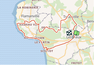
Tour Wandern von 19,3 km verfügbar auf Normandie, Manche, Les Pieux. Diese Tour wird von PascalN vorgeschlagen.
Beschreibung
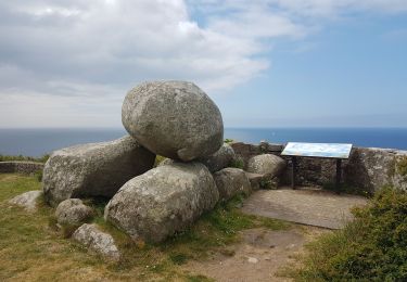
Départ du centre de Les Pieux depuis le parking derrière la mairie, direction "La roche à Coucou".Descente vers Sciotot puis le sentier littoral vers Flamanville et son château. Traversée du bois communal puis retour par Tréauville.
Ort
Land:
France
Region :
Normandie
Abteilung/Provinz :
Manche
Kommune :
Les Pieux
Standort:
Unknown
Gehen Sie:(Dec)
Gehen Sie:(UTM)
586150 ; 5485088 (30U) N.
Kommentare
Touren in der Umgebung
![Tour Wandern Les Pieux - Entre terre et mer - Les Pieux - Photo](https://media.geolcdn.com/t/375/260/ext.jpg?maxdim=2&url=https%3A%2F%2Fservices.sitytrail.com%2FGeolivesWS%2FDownloadMedia.ashx%3FTrailID%3D173114%26Media%3D14665_6.jpg)
![Wandern Wandern](https://static1.geolcdn.com/sitytour/trail-icons/101.png)
Entre terre et mer - Les Pieux
Wandern
Medium
(2)
Les Pieux,
Normandie,
Manche,
France
![](/images/other/stat-length.png)
23 km | 28 km-effort
6h 0min
![](https://static1.geolcdn.com/siteimages/upload/files/16400158638029165_repeat_loop_refresh_sync_direction_icon.png)
Ja
![Tour Mountainbike Benoîtville - De Benoîtville à Saint Christophe du Foc - Circuit n° 12 - Photo](https://media.geolcdn.com/t/375/260/ext.jpg?maxdim=2&url=https%3A%2F%2Fservices.sitytrail.com%2FGeolivesWS%2FDownloadMedia.ashx%3FTrailID%3D110389%26Media%3D5846_1.jpg)
![Mountainbike Mountainbike](https://static1.geolcdn.com/sitytour/trail-icons/202.png)
De Benoîtville à Saint Christophe du Foc - Circuit n° 12
Mountainbike
Medium
(1)
Benoîtville,
Normandie,
Manche,
France
![](/images/other/stat-length.png)
21 km | 24 km-effort
1h 45min
![](https://static1.geolcdn.com/siteimages/upload/files/16400158638029165_repeat_loop_refresh_sync_direction_icon.png)
Ja
![Tour Wandern Les Pieux - Séjour Cotentin Etape 5 Les Pieux - Barneville - Photo](https://media.geolcdn.com/t/375/260/ccdd36f2-a9ba-4c0c-9e04-9fc802c2ab0c.jpg&format=jpg&maxdim=2)
![Wandern Wandern](https://static1.geolcdn.com/sitytour/trail-icons/101.png)
Séjour Cotentin Etape 5 Les Pieux - Barneville
Wandern
Einfach
Les Pieux,
Normandie,
Manche,
France
![](/images/other/stat-length.png)
24 km | 28 km-effort
5h 8min
![](https://static1.geolcdn.com/siteimages/upload/files/16400158638029165_repeat_loop_refresh_sync_direction_icon.png)
Nein
![Tour Wandern Flamanville - Flamanville - Photo](https://media.geolcdn.com/t/375/260/0e1b6508-1f38-4364-b546-937920ff6bcb.jpg&format=jpg&maxdim=2)
![Wandern Wandern](https://static1.geolcdn.com/sitytour/trail-icons/101.png)
![Tour Wandern Flamanville - Tour du cap de Flamanville - Photo](https://media.geolcdn.com/t/375/260/d462f6fc-820d-477d-8bd6-c4583a3ed315.jpg&format=jpg&maxdim=2)
![Wandern Wandern](https://static1.geolcdn.com/sitytour/trail-icons/101.png)
Tour du cap de Flamanville
Wandern
Schwierig
Flamanville,
Normandie,
Manche,
France
![](/images/other/stat-length.png)
11,5 km | 14,6 km-effort
4h 0min
![](https://static1.geolcdn.com/siteimages/upload/files/16400158638029165_repeat_loop_refresh_sync_direction_icon.png)
Ja
![Tour Mountainbike Flamanville - Rando des Caps 2013 - 65 km - Flamanville - Photo](https://media.geolcdn.com/t/375/260/ext.jpg?maxdim=2&url=https%3A%2F%2Fservices.sitytrail.com%2FGeolivesWS%2FDownloadMedia.ashx%3FTrailID%3D215249%26Media%3D15453_4.jpg)
![Mountainbike Mountainbike](https://static1.geolcdn.com/sitytour/trail-icons/202.png)
Rando des Caps 2013 - 65 km - Flamanville
Mountainbike
Schwierig
Flamanville,
Normandie,
Manche,
France
![](/images/other/stat-length.png)
60 km | 73 km-effort
3h 30min
![](https://static1.geolcdn.com/siteimages/upload/files/16400158638029165_repeat_loop_refresh_sync_direction_icon.png)
Ja
![Tour Mountainbike Flamanville - Rando des Caps 2013 - Flamanville - Photo](https://media.geolcdn.com/t/375/260/ext.jpg?maxdim=2&url=https%3A%2F%2Fservices.sitytrail.com%2FGeolivesWS%2FDownloadMedia.ashx%3FTrailID%3D214893%26Media%3D15444_3.jpg)
![Mountainbike Mountainbike](https://static1.geolcdn.com/sitytour/trail-icons/202.png)
Rando des Caps 2013 - Flamanville
Mountainbike
Schwierig
Flamanville,
Normandie,
Manche,
France
![](/images/other/stat-length.png)
41 km | 48 km-effort
2h 45min
![](https://static1.geolcdn.com/siteimages/upload/files/16400158638029165_repeat_loop_refresh_sync_direction_icon.png)
Ja
![Tour Laufen Les Pieux - Entre terre et mer - Les Pieux - Photo](https://media.geolcdn.com/t/375/260/ext.jpg?maxdim=2&url=https%3A%2F%2Fservices.sitytrail.com%2FGeolivesWS%2FDownloadMedia.ashx%3FTrailID%3D173115%26Media%3D14665_6.jpg)
![Laufen Laufen](https://static1.geolcdn.com/sitytour/trail-icons/103.png)
Entre terre et mer - Les Pieux
Laufen
Schwierig
Les Pieux,
Normandie,
Manche,
France
![](/images/other/stat-length.png)
23 km | 28 km-effort
3h 0min
![](https://static1.geolcdn.com/siteimages/upload/files/16400158638029165_repeat_loop_refresh_sync_direction_icon.png)
Ja
![Tour Wandern Flamanville - 21 Aout Flamanville plage du sciotot boucle terre et mer - Photo](https://media.geolcdn.com/t/375/260/ext.jpg?maxdim=2&url=https%3A%2F%2Fstatic1.geolcdn.com%2Fsiteimages%2Fupload%2Ffiles%2F1553511878bg_sport_marche.png)
![Wandern Wandern](https://static1.geolcdn.com/sitytour/trail-icons/101.png)
21 Aout Flamanville plage du sciotot boucle terre et mer
Wandern
Sehr schwierig
Flamanville,
Normandie,
Manche,
France
![](/images/other/stat-length.png)
22 km | 27 km-effort
5h 26min
![](https://static1.geolcdn.com/siteimages/upload/files/16400158638029165_repeat_loop_refresh_sync_direction_icon.png)
Ja