![](/images/other/stat-length.png)
![Tour Zu Fuß Namen - Flawinne... Tracé d'un ami - Photo](https://media.geolcdn.com/t/1900/400/ext.pjpeg?maxdim=2&url=https%3A%2F%2Fstatic1.geolcdn.com%2Fsiteimages%2Fupload%2Ffiles%2F1545311037marcheuse_200dpi.jpg)
Flawinne... Tracé d'un ami
r.genette
Benutzer
![Länge](/images/other/stat-length.png)
Länge
11,3 km
![Maximale Höhe](https://static1.geolcdn.com/siteimages/upload/files/1508320355ic_sort_altitude_max_24dp.png)
Maximale Höhe
211 m
![Positive Höhendifferenz](https://static1.geolcdn.com/siteimages/upload/files/1508320355ic_sort_den_pos_24dp.png)
Positive Höhendifferenz
255 m
![Km-Effort](/images/other/stat-length.png)
Km-Effort
14,7 km
![Min. Höhe](https://static1.geolcdn.com/siteimages/upload/files/1508320355ic_sort_altitude_min_24dp.png)
Min. Höhe
79 m
![Negative Höhendifferenz](https://static1.geolcdn.com/siteimages/upload/files/1508320355ic_sort_den_neg_24dp.png)
Negative Höhendifferenz
253 m
![Boucle](https://static1.geolcdn.com/siteimages/upload/files/16400158638029165_repeat_loop_refresh_sync_direction_icon.png)
Boucle
Ja
Erstellungsdatum :
2020-12-10 15:59:46.581
Letzte Änderung :
2020-12-10 16:07:14.994
![Zu Fuß](https://static1.geolcdn.com/sitytour/trail-icons/100.png)
3h00
Schwierigkeit : Einfach
![Scannen Sie diesen QR-Code, um die Tour in der SityTrail-Anwendung zu öffnen](https://capi.geolives.com/qq0zvz2zws4bq2lad0pu/sitytour/trails/2616591/qr.png?size=200)
Kostenlosegpshiking-Anwendung
Über SityTrail
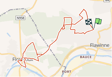
Tour Zu Fuß von 11,3 km verfügbar auf Wallonien, Namur, Namen. Diese Tour wird von r.genette vorgeschlagen.
Beschreibung
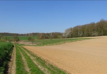
Au départ du parking foot de Flawinne vers Floriffoux, la Sambre et retour par le Château des IV Seigneurs, Château de Flawinne et foot..
très joli tracé boisé..
Ort
Land:
Belgium
Region :
Wallonien
Abteilung/Provinz :
Namur
Kommune :
Namen
Standort:
Flawinne
Gehen Sie:(Dec)
Gehen Sie:(UTM)
628383 ; 5591628 (31U) N.
Kommentare
Touren in der Umgebung
![Tour Wandern Floreffe - RB-Na-19_Autour-de-l’abbaye-de-Floreffe - Photo](https://media.geolcdn.com/t/375/260/ext.jpg?maxdim=2&url=https%3A%2F%2Fmedia.geolcdn.com%2Ff%2Fc2b23cd4-6e4c-4f39-95e8-988722356b01.JPG)
![Wandern Wandern](https://static1.geolcdn.com/sitytour/trail-icons/101.png)
RB-Na-19_Autour-de-l’abbaye-de-Floreffe
Wandern
Sehr schwierig
(17)
Floreffe,
Wallonien,
Namur,
Belgium
![](/images/other/stat-length.png)
19,9 km | 25 km-effort
5h 40min
![](https://static1.geolcdn.com/siteimages/upload/files/16400158638029165_repeat_loop_refresh_sync_direction_icon.png)
Ja
![Tour Wandern Namen - Balade dans le bois de la Vecquée - Photo](https://media.geolcdn.com/t/375/260/ext.jpg?maxdim=2&url=https%3A%2F%2Fservices.sitytrail.com%2FGeolivesWS%2FDownloadMedia.ashx%3FTrailID%3D116970%26Media%3D93b7e593-adca-4c1d-a47c-e05bb1cf45a1.JPG)
![Wandern Wandern](https://static1.geolcdn.com/sitytour/trail-icons/101.png)
Balade dans le bois de la Vecquée
Wandern
Medium
(6)
Namen,
Wallonien,
Namur,
Belgium
![](/images/other/stat-length.png)
13,2 km | 18,4 km-effort
3h 20min
![](https://static1.geolcdn.com/siteimages/upload/files/16400158638029165_repeat_loop_refresh_sync_direction_icon.png)
Ja
![Tour Wandern Namen - Nuit du scoutisme - Namur - Photo](https://media.geolcdn.com/t/375/260/ext.jpg?maxdim=2&url=https%3A%2F%2Fmedia.geolcdn.com%2Ff%2F59c09917-a863-4933-801b-fff702066ffd.jpg)
![Wandern Wandern](https://static1.geolcdn.com/sitytour/trail-icons/101.png)
Nuit du scoutisme - Namur
Wandern
Medium
(7)
Namen,
Wallonien,
Namur,
Belgium
![](/images/other/stat-length.png)
5,5 km | 6,1 km-effort
1h 32min
![](https://static1.geolcdn.com/siteimages/upload/files/16400158638029165_repeat_loop_refresh_sync_direction_icon.png)
Ja
![Tour Wandern Namen - La Plante 16 Km - Photo](https://media.geolcdn.com/t/375/260/ext.jpg?maxdim=2&url=https%3A%2F%2Fmedia.geolcdn.com%2Ff%2Fd14bf9b4-85d7-458d-beb2-079d8e396b5c.jpeg)
![Wandern Wandern](https://static1.geolcdn.com/sitytour/trail-icons/101.png)
La Plante 16 Km
Wandern
Einfach
(1)
Namen,
Wallonien,
Namur,
Belgium
![](/images/other/stat-length.png)
15,9 km | 21 km-effort
5h 34min
![](https://static1.geolcdn.com/siteimages/upload/files/16400158638029165_repeat_loop_refresh_sync_direction_icon.png)
Ja
![Tour Wandern Floreffe - RB-Na-19-Racc_Autour-de-l’abbaye-de-Floreffe - Photo](https://media.geolcdn.com/t/375/260/ext.jpg?maxdim=2&url=https%3A%2F%2Fmedia.geolcdn.com%2Ff%2F483ac6c3-68ad-4b42-9598-b5b3399e9eb6.JPG)
![Wandern Wandern](https://static1.geolcdn.com/sitytour/trail-icons/101.png)
RB-Na-19-Racc_Autour-de-l’abbaye-de-Floreffe
Wandern
Schwierig
(3)
Floreffe,
Wallonien,
Namur,
Belgium
![](/images/other/stat-length.png)
13,6 km | 17,5 km-effort
3h 58min
![](https://static1.geolcdn.com/siteimages/upload/files/16400158638029165_repeat_loop_refresh_sync_direction_icon.png)
Ja
![Tour Wandern Namen - Balade à Wépion - Photo](https://media.geolcdn.com/t/375/260/ext.jpg?maxdim=2&url=https%3A%2F%2Fservices.sitytrail.com%2FGeolivesWS%2FDownloadMedia.ashx%3FTrailID%3D424647%26Media%3D68845f3c-9f68-429e-9990-62cb43748425.JPG)
![Wandern Wandern](https://static1.geolcdn.com/sitytour/trail-icons/101.png)
Balade à Wépion
Wandern
Einfach
(4)
Namen,
Wallonien,
Namur,
Belgium
![](/images/other/stat-length.png)
11,7 km | 15,2 km-effort
3h 15min
![](https://static1.geolcdn.com/siteimages/upload/files/16400158638029165_repeat_loop_refresh_sync_direction_icon.png)
Ja
![Tour Wandern Namen - La balade des quais à Namur - Photo](https://media.geolcdn.com/t/375/260/ext.jpg?maxdim=2&url=https%3A%2F%2Fservices.sitytrail.com%2FGeolivesWS%2FDownloadMedia.ashx%3FTrailID%3D362945%26Media%3D1faf5953-f3d8-4ec7-ad30-b2dea219bb51.JPG)
![Wandern Wandern](https://static1.geolcdn.com/sitytour/trail-icons/101.png)
La balade des quais à Namur
Wandern
Sehr leicht
(3)
Namen,
Wallonien,
Namur,
Belgium
![](/images/other/stat-length.png)
7,6 km | 8,6 km-effort
1h 53min
![](https://static1.geolcdn.com/siteimages/upload/files/16400158638029165_repeat_loop_refresh_sync_direction_icon.png)
Ja
![Tour Wandern Floreffe - Balade à Floreffe - Photo](https://media.geolcdn.com/t/375/260/ext.jpg?maxdim=2&url=https%3A%2F%2Fservices.sitytrail.com%2FGeolivesWS%2FDownloadMedia.ashx%3FTrailID%3D236798%26Media%3Da4a2a0f8-d559-4930-aa85-d9a1040537b5.JPG)
![Wandern Wandern](https://static1.geolcdn.com/sitytour/trail-icons/101.png)
Balade à Floreffe
Wandern
Sehr leicht
(1)
Floreffe,
Wallonien,
Namur,
Belgium
![](/images/other/stat-length.png)
10,1 km | 14 km-effort
2h 56min
![](https://static1.geolcdn.com/siteimages/upload/files/16400158638029165_repeat_loop_refresh_sync_direction_icon.png)
Ja
![Tour Wandern Namen - De Temploux à Suarlée - Photo](https://media.geolcdn.com/t/375/260/ext.jpg?maxdim=2&url=https%3A%2F%2Fservices.sitytrail.com%2FGeolivesWS%2FDownloadMedia.ashx%3FTrailID%3D187873%26Media%3D0f5c6b3b-618b-4553-bddc-22cf26058eb0.JPG)
![Wandern Wandern](https://static1.geolcdn.com/sitytour/trail-icons/101.png)
De Temploux à Suarlée
Wandern
Einfach
(1)
Namen,
Wallonien,
Namur,
Belgium
![](/images/other/stat-length.png)
10,7 km | 12,4 km-effort
2h 40min
![](https://static1.geolcdn.com/siteimages/upload/files/16400158638029165_repeat_loop_refresh_sync_direction_icon.png)
Ja