![](/images/other/stat-length.png)
![Tour Wandern Misy-sur-Yonne - JC 03 Misy sur Yonne Les sablières - Photo](https://media.geolcdn.com/t/1900/400/836c8c29-92cc-4234-9bf1-467fa8145080.jpg&format=pjpeg&maxdim=2)
JC 03 Misy sur Yonne Les sablières
Les 1000 pattes
Club randonnées SERVON
![Länge](/images/other/stat-length.png)
Länge
22 km
![Maximale Höhe](https://static1.geolcdn.com/siteimages/upload/files/1508320355ic_sort_altitude_max_24dp.png)
Maximale Höhe
65 m
![Positive Höhendifferenz](https://static1.geolcdn.com/siteimages/upload/files/1508320355ic_sort_den_pos_24dp.png)
Positive Höhendifferenz
114 m
![Km-Effort](/images/other/stat-length.png)
Km-Effort
23 km
![Min. Höhe](https://static1.geolcdn.com/siteimages/upload/files/1508320355ic_sort_altitude_min_24dp.png)
Min. Höhe
46 m
![Negative Höhendifferenz](https://static1.geolcdn.com/siteimages/upload/files/1508320355ic_sort_den_neg_24dp.png)
Negative Höhendifferenz
115 m
![Boucle](https://static1.geolcdn.com/siteimages/upload/files/16400158638029165_repeat_loop_refresh_sync_direction_icon.png)
Boucle
Ja
Erstellungsdatum :
2020-11-23 13:41:31.25
Letzte Änderung :
2021-12-10 17:57:23.389
![Wandern](https://static1.geolcdn.com/sitytour/trail-icons/101.png)
4h33
Schwierigkeit : Schwierig
![Scannen Sie diesen QR-Code, um die Tour in der SityTrail-Anwendung zu öffnen](https://capi.geolives.com/qq0zvz2zws4bq2lad0pu/sitytour/trails/2605677/qr.png?size=200)
Kostenlosegpshiking-Anwendung
Über SityTrail
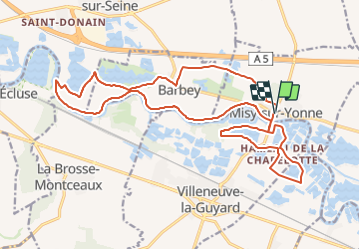
Tour Wandern von 22 km verfügbar auf Île-de-France, Seine-et-Marne, Misy-sur-Yonne. Diese Tour wird von Les 1000 pattes vorgeschlagen.
Beschreibung
Parking Place des Erables Misy sur Yonne
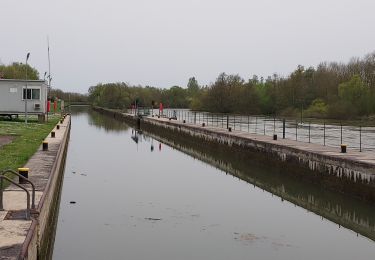
Les bords de l'Yonne et ses sablières
Trajet Servon-->Misy 62km (42mn)
Ort
Land:
France
Region :
Île-de-France
Abteilung/Provinz :
Seine-et-Marne
Kommune :
Misy-sur-Yonne
Standort:
Unknown
Gehen Sie:(Dec)
Gehen Sie:(UTM)
506601 ; 5356259 (31U) N.
Kommentare
Touren in der Umgebung
![Tour Wandern Vinneuf - Vinneuf 240407 - Photo](https://media.geolcdn.com/t/375/260/1b99c92b-3b85-447e-bf48-97fdb18795ba.jpg&format=jpg&maxdim=2)
![Wandern Wandern](https://static1.geolcdn.com/sitytour/trail-icons/101.png)
Vinneuf 240407
Wandern
Sehr leicht
Vinneuf,
Burgund und Freigrafschaft,
Yonne,
France
![](/images/other/stat-length.png)
10,6 km | 11,7 km-effort
2h 12min
![](https://static1.geolcdn.com/siteimages/upload/files/16400158638029165_repeat_loop_refresh_sync_direction_icon.png)
Ja
![Tour Zu Fuß La Brosse-Montceaux - Le Maquis des Oblats - Photo](https://media.geolcdn.com/t/375/260/ext.jpg?maxdim=2&url=https%3A%2F%2Fstatic1.geolcdn.com%2Fsiteimages%2Fupload%2Ffiles%2F1545311037marcheuse_200dpi.jpg)
![Zu Fuß Zu Fuß](https://static1.geolcdn.com/sitytour/trail-icons/100.png)
Le Maquis des Oblats
Zu Fuß
Einfach
La Brosse-Montceaux,
Île-de-France,
Seine-et-Marne,
France
![](/images/other/stat-length.png)
6,6 km | 7,6 km-effort
1h 44min
![](https://static1.geolcdn.com/siteimages/upload/files/16400158638029165_repeat_loop_refresh_sync_direction_icon.png)
Ja
![Tour Reiten Balloy - belloy - Photo](https://media.geolcdn.com/t/375/260/875ba4e1-52d7-4c14-90f4-ae7d1db63c34.jpg&format=jpg&maxdim=2)
![Reiten Reiten](https://static1.geolcdn.com/sitytour/trail-icons/301.png)
belloy
Reiten
Einfach
Balloy,
Île-de-France,
Seine-et-Marne,
France
![](/images/other/stat-length.png)
17,2 km | 18,4 km-effort
3h 55min
![](https://static1.geolcdn.com/siteimages/upload/files/16400158638029165_repeat_loop_refresh_sync_direction_icon.png)
Ja
![Tour Wandern Champigny - 31 mars 2021 - Photo](https://media.geolcdn.com/t/375/260/09a9c881-4d44-4be4-bbae-505ccc1360f3.jpg&format=jpg&maxdim=2)
![Wandern Wandern](https://static1.geolcdn.com/sitytour/trail-icons/101.png)
31 mars 2021
Wandern
Einfach
Champigny,
Burgund und Freigrafschaft,
Yonne,
France
![](/images/other/stat-length.png)
3,1 km | 3,3 km-effort
52min
![](https://static1.geolcdn.com/siteimages/upload/files/16400158638029165_repeat_loop_refresh_sync_direction_icon.png)
Ja
![Tour Wandern Marolles-sur-Seine - Boucle Marolles sur Seine - Brays sur Seine 44 km - Photo](https://media.geolcdn.com/t/375/260/ext.jpg?maxdim=2&url=https%3A%2F%2Fstatic1.geolcdn.com%2Fsiteimages%2Fupload%2Ffiles%2F1553511878bg_sport_marche.png)
![Wandern Wandern](https://static1.geolcdn.com/sitytour/trail-icons/101.png)
Boucle Marolles sur Seine - Brays sur Seine 44 km
Wandern
Sehr leicht
Marolles-sur-Seine,
Île-de-France,
Seine-et-Marne,
France
![](/images/other/stat-length.png)
44 km | 47 km-effort
10h 8min
![](https://static1.geolcdn.com/siteimages/upload/files/16400158638029165_repeat_loop_refresh_sync_direction_icon.png)
Ja
![Tour Wandern Misy-sur-Yonne - Misy sur Yonne 221120 - Photo](https://media.geolcdn.com/t/375/260/ext.jpg?maxdim=2&url=https%3A%2F%2Fstatic1.geolcdn.com%2Fsiteimages%2Fupload%2Ffiles%2F1553511878bg_sport_marche.png)
![Wandern Wandern](https://static1.geolcdn.com/sitytour/trail-icons/101.png)
Misy sur Yonne 221120
Wandern
Sehr leicht
Misy-sur-Yonne,
Île-de-France,
Seine-et-Marne,
France
![](/images/other/stat-length.png)
10,3 km | 11 km-effort
3h 10min
![](https://static1.geolcdn.com/siteimages/upload/files/16400158638029165_repeat_loop_refresh_sync_direction_icon.png)
Ja
![Tour Wandern Champigny - 05 avril 2021 - Photo](https://media.geolcdn.com/t/375/260/ext.jpg?maxdim=2&url=https%3A%2F%2Fstatic1.geolcdn.com%2Fsiteimages%2Fupload%2Ffiles%2F1553511878bg_sport_marche.png)
![Wandern Wandern](https://static1.geolcdn.com/sitytour/trail-icons/101.png)
05 avril 2021
Wandern
Medium
Champigny,
Burgund und Freigrafschaft,
Yonne,
France
![](/images/other/stat-length.png)
4,9 km | 6,1 km-effort
1h 13min
![](https://static1.geolcdn.com/siteimages/upload/files/16400158638029165_repeat_loop_refresh_sync_direction_icon.png)
Ja
![Tour Wandern Champigny - Champigny - Sens - Photo](https://media.geolcdn.com/t/375/260/ext.jpg?maxdim=2&url=https%3A%2F%2Fstatic1.geolcdn.com%2Fsiteimages%2Fupload%2Ffiles%2F1553511878bg_sport_marche.png)
![Wandern Wandern](https://static1.geolcdn.com/sitytour/trail-icons/101.png)
Champigny - Sens
Wandern
Einfach
Champigny,
Burgund und Freigrafschaft,
Yonne,
France
![](/images/other/stat-length.png)
22 km | 28 km-effort
9min
![](https://static1.geolcdn.com/siteimages/upload/files/16400158638029165_repeat_loop_refresh_sync_direction_icon.png)
Nein
![Tour Wandern Balloy - SityTrail - Balloy am - Photo](https://media.geolcdn.com/t/375/260/ext.jpg?maxdim=2&url=https%3A%2F%2Fstatic1.geolcdn.com%2Fsiteimages%2Fupload%2Ffiles%2F1553511878bg_sport_marche.png)
![Wandern Wandern](https://static1.geolcdn.com/sitytour/trail-icons/101.png)
SityTrail - Balloy am
Wandern
Medium
Balloy,
Île-de-France,
Seine-et-Marne,
France
![](/images/other/stat-length.png)
10,9 km | 11,6 km-effort
2h 35min
![](https://static1.geolcdn.com/siteimages/upload/files/16400158638029165_repeat_loop_refresh_sync_direction_icon.png)
Ja