![](/images/other/stat-length.png)
![Tour Wandern Salles - Escala du Prat du Rey - Photo](https://media.geolcdn.com/t/1900/400/ext.pjpeg?maxdim=2&url=https%3A%2F%2Fstatic1.geolcdn.com%2Fsiteimages%2Fupload%2Ffiles%2F1553511878bg_sport_marche.png)
Escala du Prat du Rey
DuMarsan
Benutzer
![Länge](/images/other/stat-length.png)
![Maximale Höhe](https://static1.geolcdn.com/siteimages/upload/files/1508320355ic_sort_altitude_max_24dp.png)
![Positive Höhendifferenz](https://static1.geolcdn.com/siteimages/upload/files/1508320355ic_sort_den_pos_24dp.png)
![Km-Effort](/images/other/stat-length.png)
![Min. Höhe](https://static1.geolcdn.com/siteimages/upload/files/1508320355ic_sort_altitude_min_24dp.png)
![Negative Höhendifferenz](https://static1.geolcdn.com/siteimages/upload/files/1508320355ic_sort_den_neg_24dp.png)
![Boucle](https://static1.geolcdn.com/siteimages/upload/files/16400158638029165_repeat_loop_refresh_sync_direction_icon.png)
![Wandern](https://static1.geolcdn.com/sitytour/trail-icons/101.png)
4h24
Schwierigkeit : Medium
![Scannen Sie diesen QR-Code, um die Tour in der SityTrail-Anwendung zu öffnen](https://capi.geolives.com/qq0zvz2zws4bq2lad0pu/sitytour/trails/259935/qr.png?size=200)
Kostenlosegpshiking-Anwendung
Über SityTrail
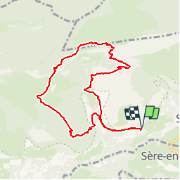
Tour Wandern von 11,3 km verfügbar auf Okzitanien, Hautes-Pyrénées, Salles. Diese Tour wird von DuMarsan vorgeschlagen.
Beschreibung
Belle boucle dans le massif de Pibeste en partie hors piste. On longe le cirque de Cauci puis le Soum des Aiguillous jusqu'à l' Escala du Prat du Rey et on redescend à travers le bois de Laurouse.
Départ = Se garer dans la carrière (indiquée sur la carte) au bord de la route, à l’ouest de Salles, avant Eclezia.
DESCRIPTIF RANDO: Prendre la piste qui monte à l’ouest. Déboucher dans la vallée de Cauci.
Prendre la piste qui monte en fond de vallée au col, cote 1193, entre le soum det mont et le soum du Prat du Rey.
De là, un chemin montant part en oblique vers l’ouest. Suivre les traces violettes qui orientent
Vers une montée raide vers le col cote 1459.
Du col partir vers l’ouest, en restant presque à niveau, et retrouver le GR qui monte depuis le col du Prat du Rey.
Progresser en forêt jusqu’à l’Escala du Prat du Rey.
Descendre jusqu’à la cote 1236. Puis descendre à travers bois jusqu’à la vallée de Cauci.
Ort
Kommentare
Touren in der Umgebung
![Tour Wandern Arcizans-Dessus - la fontaine de Nabias - Photo](https://media.geolcdn.com/t/375/260/7a92cfc2-a248-4e38-88ec-b8751d1d13fa.jpg&format=jpg&maxdim=2)
![Wandern Wandern](https://static1.geolcdn.com/sitytour/trail-icons/101.png)
Wandern
![](/images/other/stat-length.png)
![](https://static1.geolcdn.com/siteimages/upload/files/16400158638029165_repeat_loop_refresh_sync_direction_icon.png)
![Tour Wandern Argelès-Gazost - Le Mont de Gez en circuit - Argelès Gazost - Photo](https://media.geolcdn.com/t/375/260/ext.jpg?maxdim=2&url=https%3A%2F%2Fservices.sitytrail.com%2FGeolivesWS%2FDownloadMedia.ashx%3FTrailID%3D172309%26Media%3D13627_4.jpg)
![Wandern Wandern](https://static1.geolcdn.com/sitytour/trail-icons/101.png)
Wandern
![](/images/other/stat-length.png)
![](https://static1.geolcdn.com/siteimages/upload/files/16400158638029165_repeat_loop_refresh_sync_direction_icon.png)
![Tour Wandern Ségus - col du pré du roi par segus reconnu - Photo](https://media.geolcdn.com/t/375/260/8a292310-c3a3-4003-ab0e-617cb49dc561.jpg&format=jpg&maxdim=2)
![Wandern Wandern](https://static1.geolcdn.com/sitytour/trail-icons/101.png)
Wandern
![](/images/other/stat-length.png)
![](https://static1.geolcdn.com/siteimages/upload/files/16400158638029165_repeat_loop_refresh_sync_direction_icon.png)
![Tour Elektrofahrrad Argelès-Gazost - CABALIROS 30 JUIN 2023 - Photo](https://media.geolcdn.com/t/375/260/d00efa13-e401-495e-87f8-f59eb1442703.jpg&format=jpg&maxdim=2)
![Elektrofahrrad Elektrofahrrad](https://static1.geolcdn.com/sitytour/trail-icons/205.png)
Elektrofahrrad
![](/images/other/stat-length.png)
![](https://static1.geolcdn.com/siteimages/upload/files/16400158638029165_repeat_loop_refresh_sync_direction_icon.png)
![Tour Wandern Argelès-Gazost - ARGELES La boucle de l arrieulat - Photo](https://media.geolcdn.com/t/375/260/cee8eb17-b22b-4615-9318-bf7446bdbe22.jpg&format=jpg&maxdim=2)
![Wandern Wandern](https://static1.geolcdn.com/sitytour/trail-icons/101.png)
Wandern
![](/images/other/stat-length.png)
![](https://static1.geolcdn.com/siteimages/upload/files/16400158638029165_repeat_loop_refresh_sync_direction_icon.png)
![Tour Wandern Gaillagos - GAILLAGOS / Couret / Couraduque en boucle reco G3 - Photo](https://media.geolcdn.com/t/375/260/2bb3641c-adfa-48ae-af2a-1b58bf8f8276.jpg&format=jpg&maxdim=2)
![Wandern Wandern](https://static1.geolcdn.com/sitytour/trail-icons/101.png)
Wandern
![](/images/other/stat-length.png)
![](https://static1.geolcdn.com/siteimages/upload/files/16400158638029165_repeat_loop_refresh_sync_direction_icon.png)
![Tour Wandern Salles - SALLES Le col d'Andorre avec nos voisins pierrefittois - Photo](https://media.geolcdn.com/t/375/260/508ae8e7-231b-496e-8a47-feb6f918d9c1.jpg&format=jpg&maxdim=2)
![Wandern Wandern](https://static1.geolcdn.com/sitytour/trail-icons/101.png)
Wandern
![](/images/other/stat-length.png)
![](https://static1.geolcdn.com/siteimages/upload/files/16400158638029165_repeat_loop_refresh_sync_direction_icon.png)
![Tour Zu Fuß Salles - SALLES-ARGELES col d'Andorre et soum de Leiz (ou pas) 2796042 - Photo](https://media.geolcdn.com/t/375/260/2e745c69-34d8-41e1-bdf7-8d6a50b4af75.jpg&format=jpg&maxdim=2)
![Zu Fuß Zu Fuß](https://static1.geolcdn.com/sitytour/trail-icons/100.png)
Zu Fuß
![](/images/other/stat-length.png)
![](https://static1.geolcdn.com/siteimages/upload/files/16400158638029165_repeat_loop_refresh_sync_direction_icon.png)
![Tour Wandern Argelès-Gazost - ARGELES Mont de Gez G3 fait - Photo](https://media.geolcdn.com/t/375/260/653c1198-5439-4c4b-acf2-a53537be36e4.jpg&format=jpg&maxdim=2)
![Wandern Wandern](https://static1.geolcdn.com/sitytour/trail-icons/101.png)
Wandern
![](/images/other/stat-length.png)
![](https://static1.geolcdn.com/siteimages/upload/files/16400158638029165_repeat_loop_refresh_sync_direction_icon.png)