![](/images/other/stat-length.png)
![Tour Reiten Romansweiler - SityTrail - boucle Romanswiller - Château de Wangenbourg - cabane des 3 forestiers - Photo](https://media.geolcdn.com/t/1900/400/81e890ce-1b6e-4586-a252-89e1f5b74a4b.jpg&format=pjpeg&maxdim=2)
SityTrail - boucle Romanswiller - Château de Wangenbourg - cabane des 3 forestiers
Tourisme Equestre Alsace
Promouvoir le Tourisme Equestre en Alsace GUIDE+
![Länge](/images/other/stat-length.png)
![Maximale Höhe](https://static1.geolcdn.com/siteimages/upload/files/1508320355ic_sort_altitude_max_24dp.png)
![Positive Höhendifferenz](https://static1.geolcdn.com/siteimages/upload/files/1508320355ic_sort_den_pos_24dp.png)
![Km-Effort](/images/other/stat-length.png)
![Min. Höhe](https://static1.geolcdn.com/siteimages/upload/files/1508320355ic_sort_altitude_min_24dp.png)
![Negative Höhendifferenz](https://static1.geolcdn.com/siteimages/upload/files/1508320355ic_sort_den_neg_24dp.png)
![Boucle](https://static1.geolcdn.com/siteimages/upload/files/16400158638029165_repeat_loop_refresh_sync_direction_icon.png)
![Reiten](https://static1.geolcdn.com/sitytour/trail-icons/301.png)
3h54
Schwierigkeit : Medium
![Scannen Sie diesen QR-Code, um die Tour in der SityTrail-Anwendung zu öffnen](https://capi.geolives.com/qq0zvz2zws4bq2lad0pu/sitytour/trails/2590796/qr.png?size=200)
Kostenlosegpshiking-Anwendung
Über SityTrail
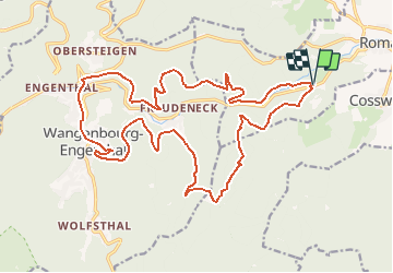
Tour Reiten von 23 km verfügbar auf Großer Osten, Unterelsass, Romansweiler. Diese Tour wird von Tourisme Equestre Alsace vorgeschlagen.
Beschreibung
Départ du Fuchsloch pour rallier le château de Wangenbourg où se trouve une halte équestre. Le tracé passe ensuite à la cabane des 3 forestiers qui comporte également une halte équestre.
Ort
Kommentare
Touren in der Umgebung
![Tour Reiten Romansweiler - 2021-09-09 Journée cosswiller Wangenbourg - Photo](https://media.geolcdn.com/t/375/260/5d20b351-3ff2-4063-998d-a626129f4cc9.jpg&format=jpg&maxdim=2)
![Reiten Reiten](https://static1.geolcdn.com/sitytour/trail-icons/301.png)
Reiten
![](/images/other/stat-length.png)
![](https://static1.geolcdn.com/siteimages/upload/files/16400158638029165_repeat_loop_refresh_sync_direction_icon.png)
![Tour Wandern Wangenburg-Engenthal - 2019-11-16 Marche Wangenbourg Castelberg - Photo](https://media.geolcdn.com/t/375/260/5fe565fb-6e88-4bed-a889-a75a33bb061a.jpg&format=jpg&maxdim=2)
![Wandern Wandern](https://static1.geolcdn.com/sitytour/trail-icons/101.png)
Wandern
![](/images/other/stat-length.png)
![](https://static1.geolcdn.com/siteimages/upload/files/16400158638029165_repeat_loop_refresh_sync_direction_icon.png)
![Tour Wandern Romansweiler - 2024-04-17_12h28m12_F2 - Photo](https://media.geolcdn.com/t/375/260/ext.jpg?maxdim=2&url=https%3A%2F%2Fstatic1.geolcdn.com%2Fsiteimages%2Fupload%2Ffiles%2F1553511878bg_sport_marche.png)
![Wandern Wandern](https://static1.geolcdn.com/sitytour/trail-icons/101.png)
Wandern
![](/images/other/stat-length.png)
![](https://static1.geolcdn.com/siteimages/upload/files/16400158638029165_repeat_loop_refresh_sync_direction_icon.png)
![Tour Wandern Wangenburg-Engenthal - 2023-04-28_17h34m45_2023-04-26_10-35(2) - Photo](https://media.geolcdn.com/t/375/260/ee107caa-b5bb-4c13-b62b-5f4288972d90.jpg&format=jpg&maxdim=2)
![Wandern Wandern](https://static1.geolcdn.com/sitytour/trail-icons/101.png)
Wandern
![](/images/other/stat-length.png)
![](https://static1.geolcdn.com/siteimages/upload/files/16400158638029165_repeat_loop_refresh_sync_direction_icon.png)
![Tour Wandern Reinhardsmünster - table des Géants - Photo](https://media.geolcdn.com/t/375/260/a89393af-280e-4d39-a5f5-36a280686cc7.jpg&format=jpg&maxdim=2)
![Wandern Wandern](https://static1.geolcdn.com/sitytour/trail-icons/101.png)
Wandern
![](/images/other/stat-length.png)
![](https://static1.geolcdn.com/siteimages/upload/files/16400158638029165_repeat_loop_refresh_sync_direction_icon.png)
![Tour Wandern Sommerau - Birkenwald Heidenschloss - Photo](https://media.geolcdn.com/t/375/260/da9bbe45-6038-4bd1-845a-cba70c3f9ae7.jpg&format=jpg&maxdim=2)
![Wandern Wandern](https://static1.geolcdn.com/sitytour/trail-icons/101.png)
Wandern
![](/images/other/stat-length.png)
![](https://static1.geolcdn.com/siteimages/upload/files/16400158638029165_repeat_loop_refresh_sync_direction_icon.png)
![Tour Wandern Wangenburg-Engenthal - Le donjon du Wangenbourg - Photo](https://media.geolcdn.com/t/375/260/514a8477-1f3a-4bae-9b88-8bb53360d534.jpg&format=jpg&maxdim=2)
![Wandern Wandern](https://static1.geolcdn.com/sitytour/trail-icons/101.png)
Wandern
![](/images/other/stat-length.png)
![](https://static1.geolcdn.com/siteimages/upload/files/16400158638029165_repeat_loop_refresh_sync_direction_icon.png)
![Tour Zu Fuß Dimbsthal - Circuit de découverte du Tannenwald - Photo](https://media.geolcdn.com/t/375/260/bdeaff6a-a7e2-455e-aede-3d09eb8e3896.jpeg&format=jpg&maxdim=2)
![Zu Fuß Zu Fuß](https://static1.geolcdn.com/sitytour/trail-icons/100.png)
Zu Fuß
![](/images/other/stat-length.png)
![](https://static1.geolcdn.com/siteimages/upload/files/16400158638029165_repeat_loop_refresh_sync_direction_icon.png)
![Tour Wandern Reinhardsmünster - Rheinhardsmunster - Photo](https://media.geolcdn.com/t/375/260/185db358-7189-47b1-8d31-3e839bf3452e.jpg&format=jpg&maxdim=2)
![Wandern Wandern](https://static1.geolcdn.com/sitytour/trail-icons/101.png)
Wandern
![](/images/other/stat-length.png)
![](https://static1.geolcdn.com/siteimages/upload/files/16400158638029165_repeat_loop_refresh_sync_direction_icon.png)