![](/images/other/stat-length.png)
![Tour Wandern Pepinster - GG-Lg-12_Pepinster - Spa - Photo](https://media.geolcdn.com/t/1900/400/6e9c02ed-2a62-46fd-9717-cfdc00c7458e.jpg&format=pjpeg&maxdim=2)
GG-Lg-12_Pepinster - Spa
GR Rando
Randonnez sur et autour des GR ® wallons (Sentiers de Grande Randonnée). PRO
![Länge](/images/other/stat-length.png)
![Maximale Höhe](https://static1.geolcdn.com/siteimages/upload/files/1508320355ic_sort_altitude_max_24dp.png)
![Positive Höhendifferenz](https://static1.geolcdn.com/siteimages/upload/files/1508320355ic_sort_den_pos_24dp.png)
![Km-Effort](/images/other/stat-length.png)
![Min. Höhe](https://static1.geolcdn.com/siteimages/upload/files/1508320355ic_sort_altitude_min_24dp.png)
![Negative Höhendifferenz](https://static1.geolcdn.com/siteimages/upload/files/1508320355ic_sort_den_neg_24dp.png)
![Boucle](https://static1.geolcdn.com/siteimages/upload/files/16400158638029165_repeat_loop_refresh_sync_direction_icon.png)
![Wandern](https://static1.geolcdn.com/sitytour/trail-icons/101.png)
6h38
Schwierigkeit : Sehr schwierig
![Scannen Sie diesen QR-Code, um die Tour in der SityTrail-Anwendung zu öffnen](https://capi.geolives.com/qq0zvz2zws4bq2lad0pu/sitytour/trails/2588277/qr.png?size=200)
Kostenlosegpshiking-Anwendung
Über SityTrail
Tour Wandern von 23 km verfügbar auf Wallonien, Lüttich, Pepinster. Diese Tour wird von GR Rando vorgeschlagen.
Beschreibung
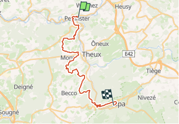
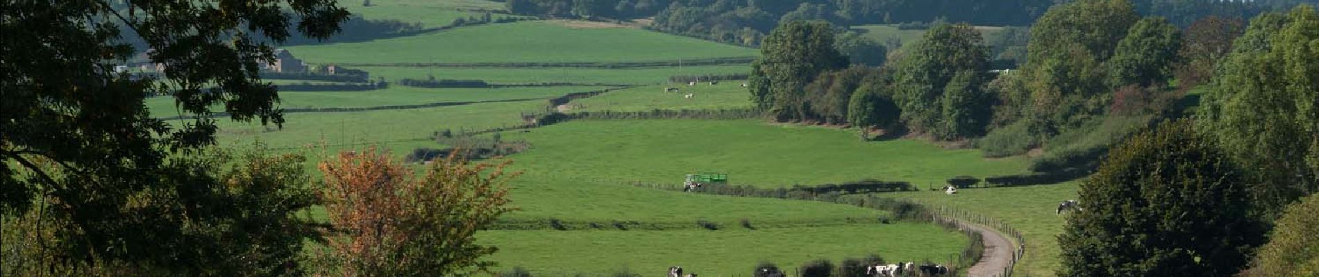
DE GARE À GARE EN PROVINCE DE LIÈGE
De Pepinster à Spa par le GR573
Pepinster – Theux – Jevoumont – Hestroumont – Spa
22,9 km
Point de départ : gare de Pepinster
Point d’arrivée : gare de Spa
Autre gare sur le parcours : Theux
Lignes SNCB 44 (Verviers - Spa) et 37 (Liège - Welkenraedt - Eupen/Aachen)
Attention : il s'agit d'une randonnée de gare à gare, cela signifie que les point de départ et d'arrivée ne sont pas identiques. Un déplacement en train permet leur interconnexion. Veuillez consulter les horaires de la ligne afin d'assurer votre transfert.
Ort
Kommentare
Touren in der Umgebung
![Tour Wandern Theux - Theux - Natura 2000, des sites qui valent le détour - LG22 - Photo](https://media.geolcdn.com/t/375/260/ext.jpg?maxdim=2&url=https%3A%2F%2Fservices.sitytrail.com%2FGeolivesWS%2FDownloadMedia.ashx%3FTrailID%3D612638%26Media%3D53072597-f13a-4b1e-b213-a2c1df094f1f.JPG)
![Wandern Wandern](https://static1.geolcdn.com/sitytour/trail-icons/101.png)
Wandern
![](/images/other/stat-length.png)
![](https://static1.geolcdn.com/siteimages/upload/files/16400158638029165_repeat_loop_refresh_sync_direction_icon.png)
![Tour Wandern Pepinster - RB-Lg-23_Soiron_via-racc-2 - Photo](https://media.geolcdn.com/t/375/260/ext.jpg?maxdim=2&url=https%3A%2F%2Fservices.sitytrail.com%2FGeolivesWS%2FDownloadMedia.ashx%3FTrailID%3D400856%26Media%3D1646b7fd-8650-448d-bc3d-5efa9ed8c932.jpg)
![Wandern Wandern](https://static1.geolcdn.com/sitytour/trail-icons/101.png)
Wandern
![](/images/other/stat-length.png)
![](https://static1.geolcdn.com/siteimages/upload/files/16400158638029165_repeat_loop_refresh_sync_direction_icon.png)
![Tour Wandern Pepinster - RB-Lg-23_Soiron - Photo](https://media.geolcdn.com/t/375/260/ext.jpg?maxdim=2&url=https%3A%2F%2Fservices.sitytrail.com%2FGeolivesWS%2FDownloadMedia.ashx%3FTrailID%3D400853%26Media%3D1646b7fd-8650-448d-bc3d-5efa9ed8c932.jpg)
![Wandern Wandern](https://static1.geolcdn.com/sitytour/trail-icons/101.png)
![Tour Wandern Trooz - RB-Lg-03 - Entre Vesdre et Hoëgne - Photo](https://media.geolcdn.com/t/375/260/ext.jpg?maxdim=2&url=https%3A%2F%2Fservices.sitytrail.com%2FGeolivesWS%2FDownloadMedia.ashx%3FTrailID%3D179559%26Media%3Dcef2de81-7d4f-4fcd-9e9d-f315370fe61f.jpg)
![Wandern Wandern](https://static1.geolcdn.com/sitytour/trail-icons/101.png)
Wandern
![](/images/other/stat-length.png)
![](https://static1.geolcdn.com/siteimages/upload/files/16400158638029165_repeat_loop_refresh_sync_direction_icon.png)
![Tour Wandern Theux - RF-Lg-08_Franchimont_Grande-boucle - Photo](https://media.geolcdn.com/t/375/260/ext.jpg?maxdim=2&url=https%3A%2F%2Fstatic1.geolcdn.com%2Fsiteimages%2Fupload%2Ffiles%2F1553511878bg_sport_marche.png)
![Wandern Wandern](https://static1.geolcdn.com/sitytour/trail-icons/101.png)
Wandern
![](/images/other/stat-length.png)
![](https://static1.geolcdn.com/siteimages/upload/files/16400158638029165_repeat_loop_refresh_sync_direction_icon.png)
![Tour Wandern Sprimont - Banneux - Rouge Thier - Adzeux - Photo](https://media.geolcdn.com/t/375/260/0f185ab2-d29a-4b49-b676-7a8415068951.jpg&format=jpg&maxdim=2)
![Wandern Wandern](https://static1.geolcdn.com/sitytour/trail-icons/101.png)
Wandern
![](/images/other/stat-length.png)
![](https://static1.geolcdn.com/siteimages/upload/files/16400158638029165_repeat_loop_refresh_sync_direction_icon.png)
![Tour Wandern Pepinster - 2022-05-13_11h44m22_Cirkwi-Soiron_6___Tribomont,_Wegnez - Photo](https://media.geolcdn.com/t/375/260/ec8c930a-9871-4566-956d-2a2016034199.jpg&format=jpg&maxdim=2)
![Wandern Wandern](https://static1.geolcdn.com/sitytour/trail-icons/101.png)
Wandern
![](/images/other/stat-length.png)
![](https://static1.geolcdn.com/siteimages/upload/files/16400158638029165_repeat_loop_refresh_sync_direction_icon.png)
![Tour Wandern Trooz - 2022-02-03_17h57m35_BaladedeFraipont - Photo](https://media.geolcdn.com/t/375/260/a22be754-a7d6-4ac7-b88b-6e30a6735908.jpg&format=jpg&maxdim=2)
![Wandern Wandern](https://static1.geolcdn.com/sitytour/trail-icons/101.png)
Wandern
![](/images/other/stat-length.png)
![](https://static1.geolcdn.com/siteimages/upload/files/16400158638029165_repeat_loop_refresh_sync_direction_icon.png)
![Wandern Wandern](https://static1.geolcdn.com/sitytour/trail-icons/101.png)
Wandern
![](/images/other/stat-length.png)
![](https://static1.geolcdn.com/siteimages/upload/files/16400158638029165_repeat_loop_refresh_sync_direction_icon.png)
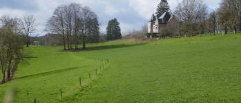
Belle randonnée, exceptés les derniers kilomètres assez bruyants avec une vue décevante (peut-être plus sympa quand la végétation est plus développée)