![](/images/other/stat-length.png)
![Tour Wandern Gilette - Tour du Mont lion (boucle inverse) - Photo](https://media.geolcdn.com/t/1900/400/c3c15adc-f8e9-40a5-922e-f77ac2d9f4ed.jpg&format=pjpeg&maxdim=2)
Tour du Mont lion (boucle inverse)
ETMU5496
Benutzer
![Länge](/images/other/stat-length.png)
Länge
16,7 km
![Maximale Höhe](https://static1.geolcdn.com/siteimages/upload/files/1508320355ic_sort_altitude_max_24dp.png)
Maximale Höhe
1017 m
![Positive Höhendifferenz](https://static1.geolcdn.com/siteimages/upload/files/1508320355ic_sort_den_pos_24dp.png)
Positive Höhendifferenz
1087 m
![Km-Effort](/images/other/stat-length.png)
Km-Effort
31 km
![Min. Höhe](https://static1.geolcdn.com/siteimages/upload/files/1508320355ic_sort_altitude_min_24dp.png)
Min. Höhe
286 m
![Negative Höhendifferenz](https://static1.geolcdn.com/siteimages/upload/files/1508320355ic_sort_den_neg_24dp.png)
Negative Höhendifferenz
1081 m
![Boucle](https://static1.geolcdn.com/siteimages/upload/files/16400158638029165_repeat_loop_refresh_sync_direction_icon.png)
Boucle
Ja
Erstellungsdatum :
2020-10-25 07:00:16.0
Letzte Änderung :
2020-10-25 18:11:31.649
![Wandern](https://static1.geolcdn.com/sitytour/trail-icons/101.png)
5h21
Schwierigkeit : Schwierig
![Scannen Sie diesen QR-Code, um die Tour in der SityTrail-Anwendung zu öffnen](https://capi.geolives.com/qq0zvz2zws4bq2lad0pu/sitytour/trails/2587487/qr.png?size=200)
Kostenlosegpshiking-Anwendung
Über SityTrail
Tour Wandern von 16,7 km verfügbar auf Provence-Alpes-Côte d'Azur, Seealpen, Gilette. Diese Tour wird von ETMU5496 vorgeschlagen.
Beschreibung
Le sentier découverte au départ de Gilette se fait en prolongement
Ort
Land:
France
Region :
Provence-Alpes-Côte d'Azur
Abteilung/Provinz :
Seealpen
Kommune :
Gilette
Standort:
Unknown
Gehen Sie:(Dec)
Gehen Sie:(UTM)
352319 ; 4857139 (32T) N.
Kommentare
Touren in der Umgebung
![Tour Zu Fuß Bouyon - track - Photo](https://media.geolcdn.com/t/375/260/69f80d39-c5dd-4687-bdd8-c0bd3948bfa4.jpg&format=jpg&maxdim=2)
![Zu Fuß Zu Fuß](https://static1.geolcdn.com/sitytour/trail-icons/100.png)
track
Zu Fuß
Medium
(1)
Bouyon,
Provence-Alpes-Côte d'Azur,
Seealpen,
France
![](/images/other/stat-length.png)
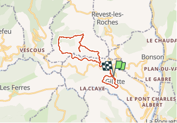
16 km | 29 km-effort
6h 0min
![](https://static1.geolcdn.com/siteimages/upload/files/16400158638029165_repeat_loop_refresh_sync_direction_icon.png)
Ja
![Tour Wandern Le Broc - Mouton d'Annou depuis lac du broc réel - Photo](https://media.geolcdn.com/t/375/260/fa7a5498-3967-4355-82a1-78d27b1b58e8.jpg&format=jpg&maxdim=2)
![Wandern Wandern](https://static1.geolcdn.com/sitytour/trail-icons/101.png)
Mouton d'Annou depuis lac du broc réel
Wandern
Sehr schwierig
Le Broc,
Provence-Alpes-Côte d'Azur,
Seealpen,
France
![](/images/other/stat-length.png)
17 km | 30 km-effort
6h 52min
![](https://static1.geolcdn.com/siteimages/upload/files/16400158638029165_repeat_loop_refresh_sync_direction_icon.png)
Ja
![Tour Wandern Utelle - Le Chaudan Madone Utelle réel - Photo](https://media.geolcdn.com/t/375/260/a8253f62-eac0-40e2-8956-546eb9ade295.jpg&format=jpg&maxdim=2)
![Wandern Wandern](https://static1.geolcdn.com/sitytour/trail-icons/101.png)
Le Chaudan Madone Utelle réel
Wandern
Sehr schwierig
Utelle,
Provence-Alpes-Côte d'Azur,
Seealpen,
France
![](/images/other/stat-length.png)
19,6 km | 37 km-effort
5h 55min
![](https://static1.geolcdn.com/siteimages/upload/files/16400158638029165_repeat_loop_refresh_sync_direction_icon.png)
Ja
![Tour Zu Fuß Utelle - Madone d'Utelle - Photo](https://media.geolcdn.com/t/375/260/186d666d-a9cf-4d78-b5ea-394e8ee2a1a9.jpeg&format=jpg&maxdim=2)
![Zu Fuß Zu Fuß](https://static1.geolcdn.com/sitytour/trail-icons/100.png)
Madone d'Utelle
Zu Fuß
Einfach
Utelle,
Provence-Alpes-Côte d'Azur,
Seealpen,
France
![](/images/other/stat-length.png)
9,9 km | 19,4 km-effort
4h 24min
![](https://static1.geolcdn.com/siteimages/upload/files/16400158638029165_repeat_loop_refresh_sync_direction_icon.png)
Ja
![Tour Zu Fuß Gilette - Tour du mont Lion - Photo](https://media.geolcdn.com/t/375/260/3f911f3e-f4fa-4a90-858d-87d89996d0ba.jpeg&format=jpg&maxdim=2)
![Zu Fuß Zu Fuß](https://static1.geolcdn.com/sitytour/trail-icons/100.png)
Tour du mont Lion
Zu Fuß
Medium
Gilette,
Provence-Alpes-Côte d'Azur,
Seealpen,
France
![](/images/other/stat-length.png)
13,4 km | 25 km-effort
5h 44min
![](https://static1.geolcdn.com/siteimages/upload/files/16400158638029165_repeat_loop_refresh_sync_direction_icon.png)
Ja
![Tour Zu Fuß Bouyon - Gorges de l'Estéron - Photo](https://media.geolcdn.com/t/375/260/e4fc29ea-3fec-4295-9d04-3873260b31c9.jpeg&format=jpg&maxdim=2)
![Zu Fuß Zu Fuß](https://static1.geolcdn.com/sitytour/trail-icons/100.png)
Gorges de l'Estéron
Zu Fuß
Medium
Bouyon,
Provence-Alpes-Côte d'Azur,
Seealpen,
France
![](/images/other/stat-length.png)
12 km | 22 km-effort
5h 3min
![](https://static1.geolcdn.com/siteimages/upload/files/16400158638029165_repeat_loop_refresh_sync_direction_icon.png)
Ja
![Tour Wandern Le Broc - mouton d'anou depuis le broc - Photo](https://media.geolcdn.com/t/375/260/ext.jpg?maxdim=2&url=https%3A%2F%2Fstatic1.geolcdn.com%2Fsiteimages%2Fupload%2Ffiles%2F1553511878bg_sport_marche.png)
![Wandern Wandern](https://static1.geolcdn.com/sitytour/trail-icons/101.png)
mouton d'anou depuis le broc
Wandern
Einfach
(1)
Le Broc,
Provence-Alpes-Côte d'Azur,
Seealpen,
France
![](/images/other/stat-length.png)
14,3 km | 23 km-effort
5h 13min
![](https://static1.geolcdn.com/siteimages/upload/files/16400158638029165_repeat_loop_refresh_sync_direction_icon.png)
Ja
![Tour Wandern Gilette - Tourette du Château depuis Gilette - Photo](https://media.geolcdn.com/t/375/260/d1e09807-10d9-4566-a82e-d368c2d70aee.jpg&format=jpg&maxdim=2)
![Wandern Wandern](https://static1.geolcdn.com/sitytour/trail-icons/101.png)
Tourette du Château depuis Gilette
Wandern
Schwierig
Gilette,
Provence-Alpes-Côte d'Azur,
Seealpen,
France
![](/images/other/stat-length.png)
18 km | 33 km-effort
7h 34min
![](https://static1.geolcdn.com/siteimages/upload/files/16400158638029165_repeat_loop_refresh_sync_direction_icon.png)
Ja
![Tour Wandern Bonson - Plan du Var-Tourrette du Château - Photo](https://media.geolcdn.com/t/375/260/b4642ae4-5db0-433c-a2e5-2905ecab06e6.jpg&format=jpg&maxdim=2)
![Wandern Wandern](https://static1.geolcdn.com/sitytour/trail-icons/101.png)
Plan du Var-Tourrette du Château
Wandern
Schwierig
Bonson,
Provence-Alpes-Côte d'Azur,
Seealpen,
France
![](/images/other/stat-length.png)
19,1 km | 35 km-effort
7h 50min
![](https://static1.geolcdn.com/siteimages/upload/files/16400158638029165_repeat_loop_refresh_sync_direction_icon.png)
Ja