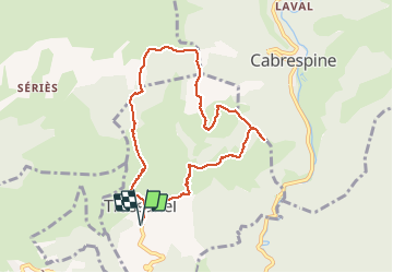
![](/images/other/stat-length.png)
![Tour Wandern Trassanel - Boucle depuis Trassanel - Grottes - Menhir - Photo](https://media.geolcdn.com/t/1900/400/d216d0dc-2e03-4857-8a0e-fd37bf09d457.jpg&format=pjpeg&maxdim=2)
Boucle depuis Trassanel - Grottes - Menhir
prous31
Benutzer
![Länge](/images/other/stat-length.png)
![Maximale Höhe](https://static1.geolcdn.com/siteimages/upload/files/1508320355ic_sort_altitude_max_24dp.png)
![Positive Höhendifferenz](https://static1.geolcdn.com/siteimages/upload/files/1508320355ic_sort_den_pos_24dp.png)
![Km-Effort](/images/other/stat-length.png)
![Min. Höhe](https://static1.geolcdn.com/siteimages/upload/files/1508320355ic_sort_altitude_min_24dp.png)
![Negative Höhendifferenz](https://static1.geolcdn.com/siteimages/upload/files/1508320355ic_sort_den_neg_24dp.png)
![Boucle](https://static1.geolcdn.com/siteimages/upload/files/16400158638029165_repeat_loop_refresh_sync_direction_icon.png)
![Wandern](https://static1.geolcdn.com/sitytour/trail-icons/101.png)
2h45
Schwierigkeit : Schwierig
![Scannen Sie diesen QR-Code, um die Tour in der SityTrail-Anwendung zu öffnen](https://capi.geolives.com/qq0zvz2zws4bq2lad0pu/sitytour/trails/2587435/qr.png?size=200)
Kostenlosegpshiking-Anwendung
Über SityTrail
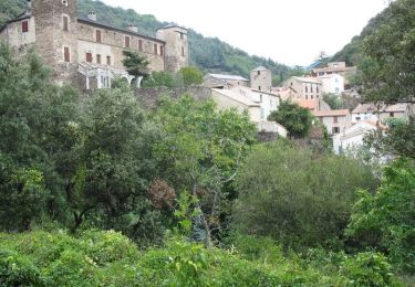
Tour Wandern von 8,9 km verfügbar auf Okzitanien, Aude, Trassanel. Diese Tour wird von prous31 vorgeschlagen.
Beschreibung
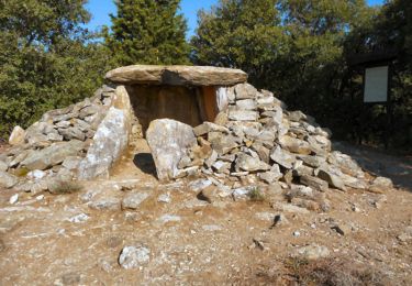
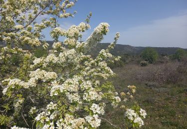
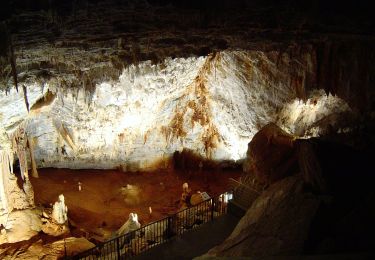
Passage devant deux grottes, beaux points de vue et menhir à la fin. Sur le retour éviter de prendre le GR36 (la route...) et prendre un petit chemin bien plus agréable qui passe par le petit menhir au Pech de Laure.
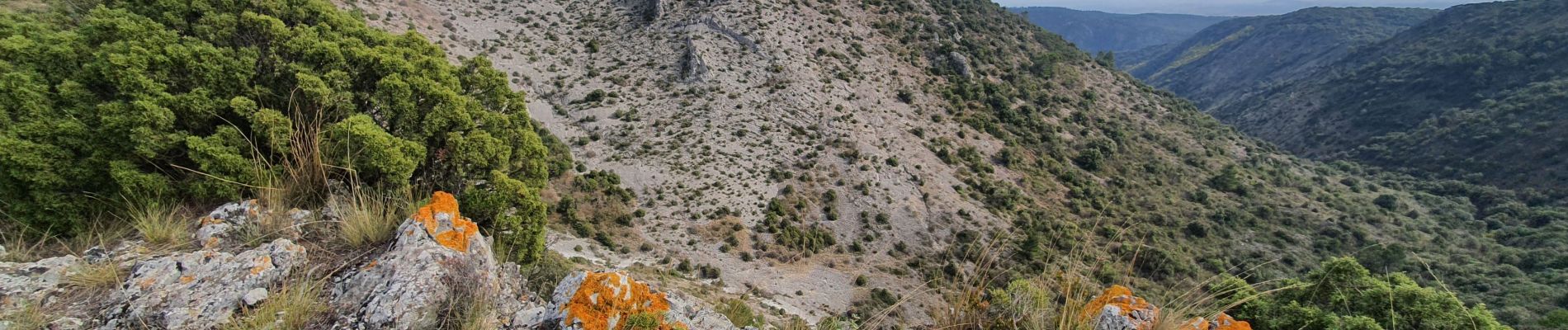
Attention : vegetation méditerranéenne = pas d'ombre.
Les montées sont raides et coupent les courbes de niveaux perpendiculairement, dans des graviers et sur des roches relativement lisses, donc probablement glissantes par temps humide.
Peut etre randonnée à faire dans le sens inverse pour avoir des montées plus progressives mais des descentes plus raides.
Ort
Kommentare
Touren in der Umgebung
![Tour Wandern Roquefère - La cascade de Cubserviès - Roquefère - Photo](https://media.geolcdn.com/t/375/260/ext.jpg?maxdim=2&url=https%3A%2F%2Fservices.sitytrail.com%2FGeolivesWS%2FDownloadMedia.ashx%3FTrailID%3D214972%26Media%3D15539_4.jpg)
![Wandern Wandern](https://static1.geolcdn.com/sitytour/trail-icons/101.png)
Wandern
![](/images/other/stat-length.png)
![](https://static1.geolcdn.com/siteimages/upload/files/16400158638029165_repeat_loop_refresh_sync_direction_icon.png)
![Tour Wandern Villeneuve-Minervois - Un air d'automne - Villeneuve Minervois - Photo](https://media.geolcdn.com/t/375/260/ext.jpg?maxdim=2&url=https%3A%2F%2Fservices.sitytrail.com%2FGeolivesWS%2FDownloadMedia.ashx%3FTrailID%3D107449%26Media%3D12373_6.jpg)
![Wandern Wandern](https://static1.geolcdn.com/sitytour/trail-icons/101.png)
Wandern
![](/images/other/stat-length.png)
![](https://static1.geolcdn.com/siteimages/upload/files/16400158638029165_repeat_loop_refresh_sync_direction_icon.png)
![Tour Wandern Lastours - Châteaux de Lastours 27-03-2022 - Photo](https://media.geolcdn.com/t/375/260/095a3ee9-2966-4db1-9ddd-42933aa80bcb.jpg&format=jpg&maxdim=2)
![Wandern Wandern](https://static1.geolcdn.com/sitytour/trail-icons/101.png)
Wandern
![](/images/other/stat-length.png)
![](https://static1.geolcdn.com/siteimages/upload/files/16400158638029165_repeat_loop_refresh_sync_direction_icon.png)
![Tour Zu Fuß Cabrespine - Les Villages Perchés - Photo](https://media.geolcdn.com/t/375/260/4379f8e7-e0a2-4ee4-810f-0aa42c1f51f8.jpeg&format=jpg&maxdim=2)
![Zu Fuß Zu Fuß](https://static1.geolcdn.com/sitytour/trail-icons/100.png)
Zu Fuß
![](/images/other/stat-length.png)
![](https://static1.geolcdn.com/siteimages/upload/files/16400158638029165_repeat_loop_refresh_sync_direction_icon.png)
![Tour Zu Fuß Labastide-Esparbairenque - Les Villages Perchés - Photo](https://media.geolcdn.com/t/375/260/87afa764-5c51-4a79-b394-b4027bc6ab46.jpeg&format=jpg&maxdim=2)
![Zu Fuß Zu Fuß](https://static1.geolcdn.com/sitytour/trail-icons/100.png)
Zu Fuß
![](/images/other/stat-length.png)
![](https://static1.geolcdn.com/siteimages/upload/files/16400158638029165_repeat_loop_refresh_sync_direction_icon.png)
![Tour Zu Fuß Cabrespine - Boucle du Gouffre de Cabrespine - Photo](https://media.geolcdn.com/t/375/260/b4f79f08-71e0-4997-b690-a17cfd5f244e.jpeg&format=jpg&maxdim=2)
![Zu Fuß Zu Fuß](https://static1.geolcdn.com/sitytour/trail-icons/100.png)
Zu Fuß
![](/images/other/stat-length.png)
![](https://static1.geolcdn.com/siteimages/upload/files/16400158638029165_repeat_loop_refresh_sync_direction_icon.png)
![Tour Wandern Les Ilhes - Les Ilhes - Photo](https://media.geolcdn.com/t/375/260/b2a5cfbf-898a-4c81-a829-ea9ff8e0beb4.jpg&format=jpg&maxdim=2)
![Wandern Wandern](https://static1.geolcdn.com/sitytour/trail-icons/101.png)
![Tour Zu Fuß Roquefère - Labastide-Espabïrenque, Prat Viel, Picarot haut - Photo](https://media.geolcdn.com/t/375/260/ext.jpg?maxdim=2&url=https%3A%2F%2Fstatic1.geolcdn.com%2Fsiteimages%2Fupload%2Ffiles%2F1545311037marcheuse_200dpi.jpg)
![Zu Fuß Zu Fuß](https://static1.geolcdn.com/sitytour/trail-icons/100.png)
Zu Fuß
![](/images/other/stat-length.png)
![](https://static1.geolcdn.com/siteimages/upload/files/16400158638029165_repeat_loop_refresh_sync_direction_icon.png)
![Tour Wandern Les Ilhes - les Trois Vallées - Photo](https://media.geolcdn.com/t/375/260/ext.jpg?maxdim=2&url=https%3A%2F%2Fstatic1.geolcdn.com%2Fsiteimages%2Fupload%2Ffiles%2F1553511878bg_sport_marche.png)
![Wandern Wandern](https://static1.geolcdn.com/sitytour/trail-icons/101.png)
Wandern
![](/images/other/stat-length.png)
![](https://static1.geolcdn.com/siteimages/upload/files/16400158638029165_repeat_loop_refresh_sync_direction_icon.png)