![](/images/other/stat-length.png)
![Tour Zu Fuß Lüttich - 3.champetre(2) - Photo](https://media.geolcdn.com/t/1900/400/ext.pjpeg?maxdim=2&url=https%3A%2F%2Fstatic1.geolcdn.com%2Fsiteimages%2Fupload%2Ffiles%2F1545311037marcheuse_200dpi.jpg)
3.champetre(2)
VDG
Benutzer
![Länge](/images/other/stat-length.png)
Länge
8,7 km
![Maximale Höhe](https://static1.geolcdn.com/siteimages/upload/files/1508320355ic_sort_altitude_max_24dp.png)
Maximale Höhe
180 m
![Positive Höhendifferenz](https://static1.geolcdn.com/siteimages/upload/files/1508320355ic_sort_den_pos_24dp.png)
Positive Höhendifferenz
283 m
![Km-Effort](/images/other/stat-length.png)
Km-Effort
12,4 km
![Min. Höhe](https://static1.geolcdn.com/siteimages/upload/files/1508320355ic_sort_altitude_min_24dp.png)
Min. Höhe
63 m
![Negative Höhendifferenz](https://static1.geolcdn.com/siteimages/upload/files/1508320355ic_sort_den_neg_24dp.png)
Negative Höhendifferenz
263 m
![Boucle](https://static1.geolcdn.com/siteimages/upload/files/16400158638029165_repeat_loop_refresh_sync_direction_icon.png)
Boucle
Nein
Erstellungsdatum :
2020-10-10 09:15:36.987
Letzte Änderung :
2020-10-10 11:35:28.075
![Zu Fuß](https://static1.geolcdn.com/sitytour/trail-icons/100.png)
3h15
Schwierigkeit : Schwierig
![Scannen Sie diesen QR-Code, um die Tour in der SityTrail-Anwendung zu öffnen](https://capi.geolives.com/qq0zvz2zws4bq2lad0pu/sitytour/trails/2573162/qr.png?size=200)
Kostenlosegpshiking-Anwendung
Über SityTrail
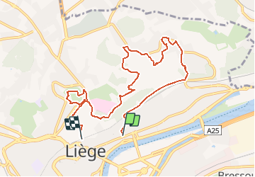
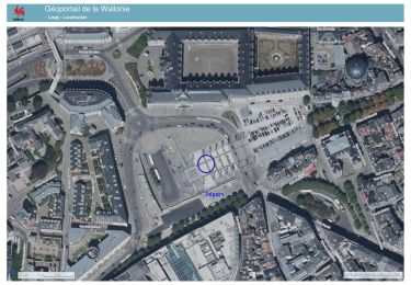
Tour Zu Fuß von 8,7 km verfügbar auf Wallonien, Lüttich, Lüttich. Diese Tour wird von VDG vorgeschlagen.
Beschreibung
Parcours Mystère Liège à pied Charly Bailly Julien Chapaux Julian Huls
Liège à pied : un guide pour découvrir Liège autrement
Les éditions de la Province de Liège
Ort
Land:
Belgium
Region :
Wallonien
Abteilung/Provinz :
Lüttich
Kommune :
Lüttich
Standort:
Liège
Gehen Sie:(Dec)
Gehen Sie:(UTM)
682578 ; 5613809 (31U) N.
Kommentare
Touren in der Umgebung
![Tour Wandern Lüttich - Nuit du scoutisme - Liège - Photo](https://media.geolcdn.com/t/375/260/9ee5fcc5-2ed6-4f9c-9105-1fa3b4422f73.jpg&format=jpg&maxdim=2)
![Wandern Wandern](https://static1.geolcdn.com/sitytour/trail-icons/101.png)
Nuit du scoutisme - Liège
Wandern
Einfach
(12)
Lüttich,
Wallonien,
Lüttich,
Belgium
![](/images/other/stat-length.png)
4,2 km | 6 km-effort
1h 19min
![](https://static1.geolcdn.com/siteimages/upload/files/16400158638029165_repeat_loop_refresh_sync_direction_icon.png)
Ja
![Tour Wandern Lüttich - coteaux de la citadelle liège - Photo](https://media.geolcdn.com/t/375/260/ext.jpg?maxdim=2&url=https%3A%2F%2Fservices.sitytrail.com%2FGeolivesWS%2FDownloadMedia.ashx%3FTrailID%3D114030%26Media%3D89e4d7f6-fadf-43e4-96ab-3cccd7baadb9.jpg)
![Wandern Wandern](https://static1.geolcdn.com/sitytour/trail-icons/101.png)
coteaux de la citadelle liège
Wandern
Medium
(6)
Lüttich,
Wallonien,
Lüttich,
Belgium
![](/images/other/stat-length.png)
14,3 km | 19,8 km-effort
7h 4min
![](https://static1.geolcdn.com/siteimages/upload/files/16400158638029165_repeat_loop_refresh_sync_direction_icon.png)
Ja
![Tour Wandern Lüttich - GG-Lg-10_Angleur - Nessonvaux - Photo](https://media.geolcdn.com/t/375/260/04d5e1fb-7fbe-4c80-8636-73a8d0ed7b0e.jpg&format=jpg&maxdim=2)
![Wandern Wandern](https://static1.geolcdn.com/sitytour/trail-icons/101.png)
GG-Lg-10_Angleur - Nessonvaux
Wandern
Sehr schwierig
(2)
Lüttich,
Wallonien,
Lüttich,
Belgium
![](/images/other/stat-length.png)
22 km | 32 km-effort
6h 27min
![](https://static1.geolcdn.com/siteimages/upload/files/16400158638029165_repeat_loop_refresh_sync_direction_icon.png)
Nein
![Tour Wandern Lüttich - liege st lambert versant gauche entre ville et nature - Photo](https://media.geolcdn.com/t/375/260/88c52680-ebe2-4244-8d59-4bcee560958c.jpg&format=jpg&maxdim=2)
![Wandern Wandern](https://static1.geolcdn.com/sitytour/trail-icons/101.png)
liege st lambert versant gauche entre ville et nature
Wandern
Medium
(1)
Lüttich,
Wallonien,
Lüttich,
Belgium
![](/images/other/stat-length.png)
10,5 km | 14 km-effort
2h 31min
![](https://static1.geolcdn.com/siteimages/upload/files/16400158638029165_repeat_loop_refresh_sync_direction_icon.png)
Ja
![Tour Wandern Lüttich - 2021-03-07_15h45m11_1615128300605_UnnMrtGYyrs - Photo](https://media.geolcdn.com/t/375/260/1db82134-c6f1-4cf9-9ec5-4781d8a78844.jpg&format=jpg&maxdim=2)
![Wandern Wandern](https://static1.geolcdn.com/sitytour/trail-icons/101.png)
2021-03-07_15h45m11_1615128300605_UnnMrtGYyrs
Wandern
Einfach
(1)
Lüttich,
Wallonien,
Lüttich,
Belgium
![](/images/other/stat-length.png)
3 km | 3,9 km-effort
53min
![](https://static1.geolcdn.com/siteimages/upload/files/16400158638029165_repeat_loop_refresh_sync_direction_icon.png)
Ja
![Tour Wandern Lüttich - angleur . bois st Jacques . sart tilman . bois st laurent . angleur - Photo](https://media.geolcdn.com/t/375/260/5602ae0a-194b-47b6-a04f-43cf9258bbf9.jpg&format=jpg&maxdim=2)
![Wandern Wandern](https://static1.geolcdn.com/sitytour/trail-icons/101.png)
angleur . bois st Jacques . sart tilman . bois st laurent . angleur
Wandern
Sehr leicht
(4)
Lüttich,
Wallonien,
Lüttich,
Belgium
![](/images/other/stat-length.png)
10,9 km | 14,1 km-effort
2h 40min
![](https://static1.geolcdn.com/siteimages/upload/files/16400158638029165_repeat_loop_refresh_sync_direction_icon.png)
Ja
![Tour Wandern Lüttich - Angleur au fil de l'eau - Photo](https://media.geolcdn.com/t/375/260/ext.jpg?maxdim=2&url=https%3A%2F%2Fservices.sitytrail.com%2FGeolivesWS%2FDownloadMedia.ashx%3FTrailID%3D163767%26Media%3D20121122171817.jpeg)
![Wandern Wandern](https://static1.geolcdn.com/sitytour/trail-icons/101.png)
Angleur au fil de l'eau
Wandern
Sehr leicht
(1)
Lüttich,
Wallonien,
Lüttich,
Belgium
![](/images/other/stat-length.png)
5,9 km | 6,5 km-effort
1h 29min
![](https://static1.geolcdn.com/siteimages/upload/files/16400158638029165_repeat_loop_refresh_sync_direction_icon.png)
Ja
![Tour Wandern Lüttich - Liège - Au fil de l'eau - Photo](https://media.geolcdn.com/t/375/260/8c09c893-4ffe-470b-95bd-9bda5ce59d47.jpg&format=jpg&maxdim=2)
![Wandern Wandern](https://static1.geolcdn.com/sitytour/trail-icons/101.png)
Liège - Au fil de l'eau
Wandern
Sehr leicht
Lüttich,
Wallonien,
Lüttich,
Belgium
![](/images/other/stat-length.png)
10,3 km | 12 km-effort
2h 30min
![](https://static1.geolcdn.com/siteimages/upload/files/16400158638029165_repeat_loop_refresh_sync_direction_icon.png)
Ja
![Tour Wandern Lüttich - 20231029 - TOTEMUS Liège](https://media.geolcdn.com/t/375/260/7b2ecb7c-b811-49e3-b8cb-f4a6ee7afc27.jpeg&format=jpg&maxdim=2)
![Wandern Wandern](https://static1.geolcdn.com/sitytour/trail-icons/101.png)
20231029 - TOTEMUS Liège " De Notger au Palais provincial en passant par la B...
Wandern
Einfach
Lüttich,
Wallonien,
Lüttich,
Belgium
![](/images/other/stat-length.png)
3,9 km | 4,3 km-effort
1h 3min
![](https://static1.geolcdn.com/siteimages/upload/files/16400158638029165_repeat_loop_refresh_sync_direction_icon.png)
Ja
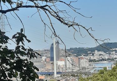
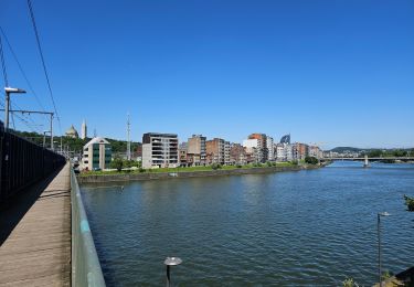
Merci aux auteurs du livre pour la découverte de ces petits coins cachés de Liège. Passage par le Village de Noël 🎄 🎅
Un beau parcours vallonné ! Merci