![](/images/other/stat-length.png)
![Tour Wandern Ramatuelle - Cap Taillat et Cap Lardier - Photo](https://media.geolcdn.com/t/1900/400/6865b4e2-141d-4244-bce3-6ec187225605.jpg&format=pjpeg&maxdim=2)
Cap Taillat et Cap Lardier
domi06
Benutzer
![Länge](/images/other/stat-length.png)
![Maximale Höhe](https://static1.geolcdn.com/siteimages/upload/files/1508320355ic_sort_altitude_max_24dp.png)
![Positive Höhendifferenz](https://static1.geolcdn.com/siteimages/upload/files/1508320355ic_sort_den_pos_24dp.png)
![Km-Effort](/images/other/stat-length.png)
![Min. Höhe](https://static1.geolcdn.com/siteimages/upload/files/1508320355ic_sort_altitude_min_24dp.png)
![Negative Höhendifferenz](https://static1.geolcdn.com/siteimages/upload/files/1508320355ic_sort_den_neg_24dp.png)
![Boucle](https://static1.geolcdn.com/siteimages/upload/files/16400158638029165_repeat_loop_refresh_sync_direction_icon.png)
![Wandern](https://static1.geolcdn.com/sitytour/trail-icons/101.png)
6h22
Schwierigkeit : Medium
![Scannen Sie diesen QR-Code, um die Tour in der SityTrail-Anwendung zu öffnen](https://capi.geolives.com/qq0zvz2zws4bq2lad0pu/sitytour/trails/2571728/qr.png?size=200)
Kostenlosegpshiking-Anwendung
Über SityTrail
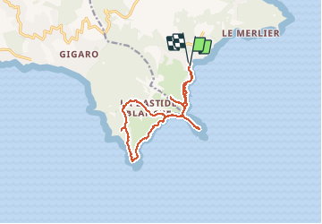
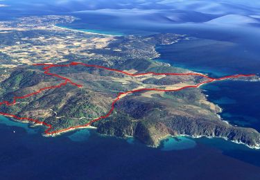
Tour Wandern von 14,2 km verfügbar auf Provence-Alpes-Côte d'Azur, Var, Ramatuelle. Diese Tour wird von domi06 vorgeschlagen.
Beschreibung
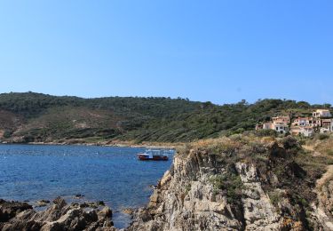
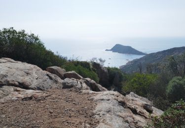
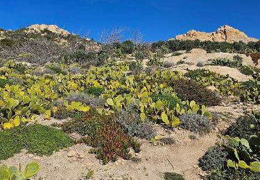
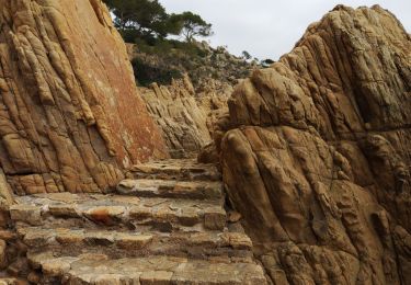
Belle randonnée dans le Var dans la presqu'île de St Tropez. Départ de la plage de l'Escalet. A l'aller prendre le sentier du littoral, escarpé, montant et descendant jusqu'au cap Taillat relié à la cote par un isthme sableux. Avant de gravir le sentier qui mène à son sommet( Magnifique point de vue), aller jusqu'à jusqu'à la maison des douaniers. Juste derrière celle-ci, prendre le sentier qui s'élève vers l'intérieur des terres. Il passe devant un ancien dolmen dont il ne reste que 2 pierres debout (dolmen de la Briande). Puis direction cap Lardier .Retour par la montée du vieux Sémaphore , bastide blanche, très beaux points de vue. Continuer à travers les vignes, puis retour par le sentier du littoral
Ort
Kommentare
Touren in der Umgebung
![Tour Zu Fuß La Croix-Valmer - La Croix Valmer - Gigaro - Taillat - Collebasse - Gigaro - Photo](https://media.geolcdn.com/t/375/260/a03cc7dc-d40c-427d-bc15-d4c3c8fead2d.jpg&format=jpg&maxdim=2)
![Zu Fuß Zu Fuß](https://static1.geolcdn.com/sitytour/trail-icons/100.png)
Zu Fuß
![](/images/other/stat-length.png)
![](https://static1.geolcdn.com/siteimages/upload/files/16400158638029165_repeat_loop_refresh_sync_direction_icon.png)
![Tour Elektrofahrrad La Croix-Valmer - Rayol -Oppidum version 2 - Photo](https://media.geolcdn.com/t/375/260/fc5cd018-661e-4f17-bef8-76baca0d8415.jpg&format=jpg&maxdim=2)
![Elektrofahrrad Elektrofahrrad](https://static1.geolcdn.com/sitytour/trail-icons/205.png)
Elektrofahrrad
![](/images/other/stat-length.png)
![](https://static1.geolcdn.com/siteimages/upload/files/16400158638029165_repeat_loop_refresh_sync_direction_icon.png)
![Tour Elektrofahrrad La Croix-Valmer - Rayol -Oppidum - Photo](https://media.geolcdn.com/t/375/260/fc5cd018-661e-4f17-bef8-76baca0d8415.jpg&format=jpg&maxdim=2)
![Elektrofahrrad Elektrofahrrad](https://static1.geolcdn.com/sitytour/trail-icons/205.png)
Elektrofahrrad
![](/images/other/stat-length.png)
![](https://static1.geolcdn.com/siteimages/upload/files/16400158638029165_repeat_loop_refresh_sync_direction_icon.png)
![Tour Wandern Ramatuelle - Le cap Camarat - Photo](https://media.geolcdn.com/t/375/260/ext.jpg?maxdim=2&url=https%3A%2F%2Fservices.sitytrail.com%2FGeolivesWS%2FDownloadMedia.ashx%3FTrailID%3D787295%26Media%3D869e75b8-d08c-458a-b38d-0a864e88844b.JPG)
![Wandern Wandern](https://static1.geolcdn.com/sitytour/trail-icons/101.png)
Wandern
![](/images/other/stat-length.png)
![](https://static1.geolcdn.com/siteimages/upload/files/16400158638029165_repeat_loop_refresh_sync_direction_icon.png)
![Tour Mountainbike Ramatuelle - Ramatuelle moulins de Paillas et Patapans.gpx - Photo](https://media.geolcdn.com/t/375/260/ext.jpg?maxdim=2&url=https%3A%2F%2Fstatic1.geolcdn.com%2Fsiteimages%2Fupload%2Ffiles%2F1524743154velo.jpg)
![Mountainbike Mountainbike](https://static1.geolcdn.com/sitytour/trail-icons/202.png)
Mountainbike
![](/images/other/stat-length.png)
![](https://static1.geolcdn.com/siteimages/upload/files/16400158638029165_repeat_loop_refresh_sync_direction_icon.png)
![Tour Wandern La Croix-Valmer - Cap Lardier - Photo](https://media.geolcdn.com/t/375/260/ext.jpg?maxdim=2&url=https%3A%2F%2Fstatic1.geolcdn.com%2Fsiteimages%2Fupload%2Ffiles%2F1553511878bg_sport_marche.png)
![Wandern Wandern](https://static1.geolcdn.com/sitytour/trail-icons/101.png)
Wandern
![](/images/other/stat-length.png)
![](https://static1.geolcdn.com/siteimages/upload/files/16400158638029165_repeat_loop_refresh_sync_direction_icon.png)
![Tour Wandern Ramatuelle - Cap Taillat - Photo](https://media.geolcdn.com/t/375/260/c19e1d17-4219-4145-aa57-37ef6d706476.jpg&format=jpg&maxdim=2)
![Wandern Wandern](https://static1.geolcdn.com/sitytour/trail-icons/101.png)
Wandern
![](/images/other/stat-length.png)
![](https://static1.geolcdn.com/siteimages/upload/files/16400158638029165_repeat_loop_refresh_sync_direction_icon.png)
![Tour Wandern La Croix-Valmer - GIGARO . cap Taillat. AB -1 - Photo](https://media.geolcdn.com/t/375/260/816705b7-121a-4690-b7dd-3111fd3ff4d3.jpg&format=jpg&maxdim=2)
![Wandern Wandern](https://static1.geolcdn.com/sitytour/trail-icons/101.png)
Wandern
![](/images/other/stat-length.png)
![](https://static1.geolcdn.com/siteimages/upload/files/16400158638029165_repeat_loop_refresh_sync_direction_icon.png)
![Tour Wandern Ramatuelle - Cap Camarat - Photo](https://media.geolcdn.com/t/375/260/3ece29cc-b215-4df0-ac82-e0f419310b1a.jpg&format=jpg&maxdim=2)
![Wandern Wandern](https://static1.geolcdn.com/sitytour/trail-icons/101.png)
Wandern
![](/images/other/stat-length.png)
![](https://static1.geolcdn.com/siteimages/upload/files/16400158638029165_repeat_loop_refresh_sync_direction_icon.png)