![](/images/other/stat-length.png)
![Tour Wandern Gumiane - le Merlu - Photo](https://media.geolcdn.com/t/1900/400/519ae12a-4541-459c-99dd-41c709c1a9c7.jpg&format=pjpeg&maxdim=2)
le Merlu
ajd26
Benutzer
![Länge](/images/other/stat-length.png)
![Maximale Höhe](https://static1.geolcdn.com/siteimages/upload/files/1508320355ic_sort_altitude_max_24dp.png)
![Positive Höhendifferenz](https://static1.geolcdn.com/siteimages/upload/files/1508320355ic_sort_den_pos_24dp.png)
![Km-Effort](/images/other/stat-length.png)
![Min. Höhe](https://static1.geolcdn.com/siteimages/upload/files/1508320355ic_sort_altitude_min_24dp.png)
![Negative Höhendifferenz](https://static1.geolcdn.com/siteimages/upload/files/1508320355ic_sort_den_neg_24dp.png)
![Boucle](https://static1.geolcdn.com/siteimages/upload/files/16400158638029165_repeat_loop_refresh_sync_direction_icon.png)
![Wandern](https://static1.geolcdn.com/sitytour/trail-icons/101.png)
4h13
Schwierigkeit : Medium
![Scannen Sie diesen QR-Code, um die Tour in der SityTrail-Anwendung zu öffnen](https://capi.geolives.com/qq0zvz2zws4bq2lad0pu/sitytour/trails/2565787/qr.png?size=200)
Kostenlosegpshiking-Anwendung
Über SityTrail
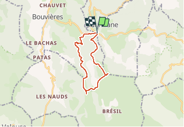
Tour Wandern von 11,6 km verfügbar auf Auvergne-Rhone-Alpen, Drôme, Gumiane. Diese Tour wird von ajd26 vorgeschlagen.
Beschreibung
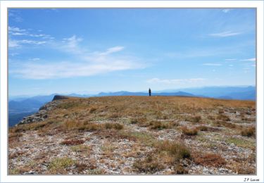
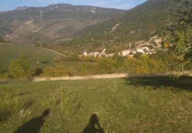
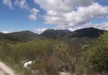
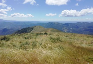
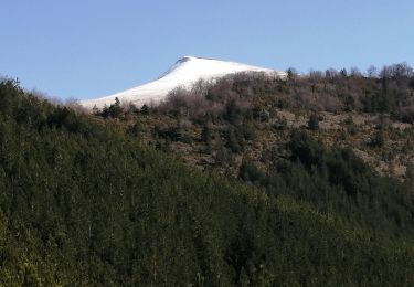
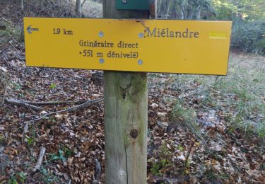
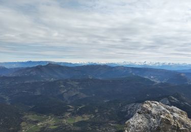
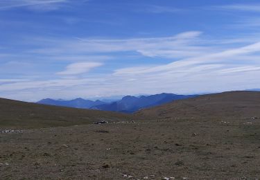
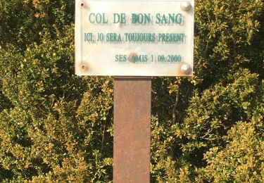
départ du col de Lescou, monté au Merlu qi n'est normalement pas autorisé mais il n'y a plus de panneau d'interdiction, superbe point de vue à 360°, descente par le col Garéou ( on a trouvé d'énormes champignons), puis col du Bon Sang, il ne faudrait pas descendre tout de suite à droite mais continuer en crête, passé la cote 1256 et dans 500m environ,prendre à droite (il y a une trace) pour rejoindre le chemin dans le vallon
Ort
Kommentare
Touren in der Umgebung
![Tour Wandern Villeperdrix - Montagne d'Angèle - Photo](https://media.geolcdn.com/t/375/260/ext.jpg?maxdim=2&url=https%3A%2F%2Fservices.sitytrail.com%2FGeolivesWS%2FDownloadMedia.ashx%3FTrailID%3D104539%26Media%3D7884_4.jpg)
![Wandern Wandern](https://static1.geolcdn.com/sitytour/trail-icons/101.png)
Wandern
![](/images/other/stat-length.png)
![](https://static1.geolcdn.com/siteimages/upload/files/16400158638029165_repeat_loop_refresh_sync_direction_icon.png)
![Tour Wandern Bouvières - 26 mielandre 09.2023 - Photo](https://media.geolcdn.com/t/375/260/5b567aa0-d7b4-48f7-ae8b-e3567a1c2c82.jpg&format=jpg&maxdim=2)
![Wandern Wandern](https://static1.geolcdn.com/sitytour/trail-icons/101.png)
Wandern
![](/images/other/stat-length.png)
![](https://static1.geolcdn.com/siteimages/upload/files/16400158638029165_repeat_loop_refresh_sync_direction_icon.png)
![Tour Wandern Gumiane - Angèle - Photo](https://media.geolcdn.com/t/375/260/4a109e75-c91a-41b5-b20f-b684de899b3e.jpg&format=jpg&maxdim=2)
![Wandern Wandern](https://static1.geolcdn.com/sitytour/trail-icons/101.png)
Wandern
![](/images/other/stat-length.png)
![](https://static1.geolcdn.com/siteimages/upload/files/16400158638029165_repeat_loop_refresh_sync_direction_icon.png)
![Tour Wandern Vesc - Mielandre par col d'Espreaux 7km - Photo](https://media.geolcdn.com/t/375/260/d636efce-2d2e-4f2f-885e-11899dc3cecf.jpg&format=jpg&maxdim=2)
![Wandern Wandern](https://static1.geolcdn.com/sitytour/trail-icons/101.png)
Wandern
![](/images/other/stat-length.png)
![](https://static1.geolcdn.com/siteimages/upload/files/16400158638029165_repeat_loop_refresh_sync_direction_icon.png)
![Tour Wandern Chaudebonne - la serre de créma - Photo](https://media.geolcdn.com/t/375/260/c1f4414d-5881-4e6a-9769-3a88a282ace5.jpg&format=jpg&maxdim=2)
![Wandern Wandern](https://static1.geolcdn.com/sitytour/trail-icons/101.png)
Wandern
![](/images/other/stat-length.png)
![](https://static1.geolcdn.com/siteimages/upload/files/16400158638029165_repeat_loop_refresh_sync_direction_icon.png)
![Tour Wandern Bouvières - Mielandre - Photo](https://media.geolcdn.com/t/375/260/871654f3-1375-4094-b447-b3b8c9304919.jpg&format=jpg&maxdim=2)
![Wandern Wandern](https://static1.geolcdn.com/sitytour/trail-icons/101.png)
Wandern
![](/images/other/stat-length.png)
![](https://static1.geolcdn.com/siteimages/upload/files/16400158638029165_repeat_loop_refresh_sync_direction_icon.png)
![Tour Wandern Gumiane - le merlu, Montagne d'Angèle depuis col de lescou - Photo](https://media.geolcdn.com/t/375/260/060c11fa-484b-49bf-8bbc-22971b83dc3e.jpg&format=jpg&maxdim=2)
![Wandern Wandern](https://static1.geolcdn.com/sitytour/trail-icons/101.png)
Wandern
![](/images/other/stat-length.png)
![](https://static1.geolcdn.com/siteimages/upload/files/16400158638029165_repeat_loop_refresh_sync_direction_icon.png)
![Tour Wandern Bouvières - le merlu - Photo](https://media.geolcdn.com/t/375/260/7ba61d90-acd3-478e-807b-3a93b5e291b2.jpg&format=jpg&maxdim=2)
![Wandern Wandern](https://static1.geolcdn.com/sitytour/trail-icons/101.png)
Wandern
![](/images/other/stat-length.png)
![](https://static1.geolcdn.com/siteimages/upload/files/16400158638029165_repeat_loop_refresh_sync_direction_icon.png)
![Tour Wandern Chaudebonne - Chaudebonne, Serre Créma - Photo](https://media.geolcdn.com/t/375/260/db518704-35c9-49cc-9247-010de1b6ece9.jpg&format=jpg&maxdim=2)
![Wandern Wandern](https://static1.geolcdn.com/sitytour/trail-icons/101.png)
Wandern
![](/images/other/stat-length.png)
![](https://static1.geolcdn.com/siteimages/upload/files/16400158638029165_repeat_loop_refresh_sync_direction_icon.png)