![](/images/other/stat-length.png)
![Tour Wandern Weset - argenteau-wixhou - Photo](https://media.geolcdn.com/t/1900/400/ext.pjpeg?maxdim=2&url=https%3A%2F%2Fstatic1.geolcdn.com%2Fsiteimages%2Fupload%2Ffiles%2F1553511878bg_sport_marche.png)
argenteau-wixhou
c.watrin
Benutzer
![Länge](/images/other/stat-length.png)
Länge
8,2 km
![Maximale Höhe](https://static1.geolcdn.com/siteimages/upload/files/1508320355ic_sort_altitude_max_24dp.png)
Maximale Höhe
161 m
![Positive Höhendifferenz](https://static1.geolcdn.com/siteimages/upload/files/1508320355ic_sort_den_pos_24dp.png)
Positive Höhendifferenz
184 m
![Km-Effort](/images/other/stat-length.png)
Km-Effort
10,6 km
![Min. Höhe](https://static1.geolcdn.com/siteimages/upload/files/1508320355ic_sort_altitude_min_24dp.png)
Min. Höhe
63 m
![Negative Höhendifferenz](https://static1.geolcdn.com/siteimages/upload/files/1508320355ic_sort_den_neg_24dp.png)
Negative Höhendifferenz
186 m
![Boucle](https://static1.geolcdn.com/siteimages/upload/files/16400158638029165_repeat_loop_refresh_sync_direction_icon.png)
Boucle
Ja
Erstellungsdatum :
2020-09-25 10:46:45.95
Letzte Änderung :
2020-09-25 13:07:59.732
![Wandern](https://static1.geolcdn.com/sitytour/trail-icons/101.png)
--
Schwierigkeit : Unbekannt
![Scannen Sie diesen QR-Code, um die Tour in der SityTrail-Anwendung zu öffnen](https://capi.geolives.com/qq0zvz2zws4bq2lad0pu/sitytour/trails/2561206/qr.png?size=200)
Kostenlosegpshiking-Anwendung
Über SityTrail
Tour Wandern von 8,2 km verfügbar auf Wallonien, Lüttich, Weset. Diese Tour wird von c.watrin vorgeschlagen.
Beschreibung
Promenade dans les bois de la Julienne....
Départ : soit de la friterie "A l'orée du bois",
soit du parking des étangs de la Julienne....
Ort
Land:
Belgium
Region :
Wallonien
Abteilung/Provinz :
Lüttich
Kommune :
Weset
Standort:
Argenteau
Gehen Sie:(Dec)
Gehen Sie:(UTM)
689936 ; 5620084 (31U) N.
Kommentare
Touren in der Umgebung
![Tour Wandern Dalhem - dalhem Bombaye aubin mortroux dalhem - Photo](https://media.geolcdn.com/t/375/260/16a64587-f39e-4282-a4fc-c52e1169e4ec.jpg&format=jpg&maxdim=2)
![Wandern Wandern](https://static1.geolcdn.com/sitytour/trail-icons/101.png)
dalhem Bombaye aubin mortroux dalhem
Wandern
Einfach
(5)
Dalhem,
Wallonien,
Lüttich,
Belgium
![](/images/other/stat-length.png)
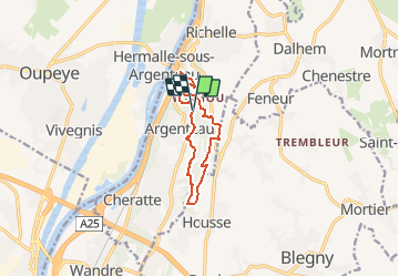
10,9 km | 12,6 km-effort
2h 40min
![](https://static1.geolcdn.com/siteimages/upload/files/16400158638029165_repeat_loop_refresh_sync_direction_icon.png)
Ja
![Tour Wandern Dalhem - dalhem tunnel . nelhain . la tombe . la folie. dalhrm - Photo](https://media.geolcdn.com/t/375/260/69f57071-dca8-4a6e-ab63-e929cdeb9e89.jpg&format=jpg&maxdim=2)
![Wandern Wandern](https://static1.geolcdn.com/sitytour/trail-icons/101.png)
dalhem tunnel . nelhain . la tombe . la folie. dalhrm
Wandern
Sehr leicht
(7)
Dalhem,
Wallonien,
Lüttich,
Belgium
![](/images/other/stat-length.png)
8,9 km | 10,6 km-effort
2h 3min
![](https://static1.geolcdn.com/siteimages/upload/files/16400158638029165_repeat_loop_refresh_sync_direction_icon.png)
Ja
![Tour Wandern Weset - 2024-06-16_18h10m24_1489.gpx.xml - Photo](https://media.geolcdn.com/t/375/260/d0453d3e-7a76-47f8-90f9-7c05ed843e1f.jpg&format=jpg&maxdim=2)
![Wandern Wandern](https://static1.geolcdn.com/sitytour/trail-icons/101.png)
2024-06-16_18h10m24_1489.gpx.xml
Wandern
Medium
(1)
Weset,
Wallonien,
Lüttich,
Belgium
![](/images/other/stat-length.png)
9,3 km | 11,5 km-effort
2h 36min
![](https://static1.geolcdn.com/siteimages/upload/files/16400158638029165_repeat_loop_refresh_sync_direction_icon.png)
Ja
![Tour Wandern Blegny - 2023-07-28_14h00m33_1702.gpx.xml - Photo](https://media.geolcdn.com/t/375/260/08e717c2-a47c-47f0-9a4e-fb7b564b3f18.jpg&format=jpg&maxdim=2)
![Wandern Wandern](https://static1.geolcdn.com/sitytour/trail-icons/101.png)
2023-07-28_14h00m33_1702.gpx.xml
Wandern
Einfach
(1)
Blegny,
Wallonien,
Lüttich,
Belgium
![](/images/other/stat-length.png)
9,9 km | 11,8 km-effort
2h 40min
![](https://static1.geolcdn.com/siteimages/upload/files/16400158638029165_repeat_loop_refresh_sync_direction_icon.png)
Ja
![Tour Wandern Blegny - 20230703 - Blegny-Mine 6.8 Km - Photo](https://media.geolcdn.com/t/375/260/840a4c96-62cb-4388-9c6c-d720f9bd1cc9.jpeg&format=jpg&maxdim=2)
![Wandern Wandern](https://static1.geolcdn.com/sitytour/trail-icons/101.png)
20230703 - Blegny-Mine 6.8 Km
Wandern
Medium
(1)
Blegny,
Wallonien,
Lüttich,
Belgium
![](/images/other/stat-length.png)
6,8 km | 8,6 km-effort
2h 8min
![](https://static1.geolcdn.com/siteimages/upload/files/16400158638029165_repeat_loop_refresh_sync_direction_icon.png)
Ja
![Tour Wandern Weset - Domaine de la Julienne - Photo](https://media.geolcdn.com/t/375/260/5e4777ba-1a15-488d-98c7-dac2d98d32bb.jpg&format=jpg&maxdim=2)
![Wandern Wandern](https://static1.geolcdn.com/sitytour/trail-icons/101.png)
Domaine de la Julienne
Wandern
Einfach
(1)
Weset,
Wallonien,
Lüttich,
Belgium
![](/images/other/stat-length.png)
7,3 km | 9,5 km-effort
2h 9min
![](https://static1.geolcdn.com/siteimages/upload/files/16400158638029165_repeat_loop_refresh_sync_direction_icon.png)
Ja
![Tour Wandern Oupeye - Promenade](https://media.geolcdn.com/t/375/260/4c0dc939-dd1a-4913-b8bc-ece5c8f95bc2.jpg&format=jpg&maxdim=2)
![Wandern Wandern](https://static1.geolcdn.com/sitytour/trail-icons/101.png)
Promenade "Histoire d'eau"
Wandern
Medium
(5)
Oupeye,
Wallonien,
Lüttich,
Belgium
![](/images/other/stat-length.png)
5,9 km | 6,3 km-effort
2h 3min
![](https://static1.geolcdn.com/siteimages/upload/files/16400158638029165_repeat_loop_refresh_sync_direction_icon.png)
Ja
![Tour Wandern Blegny - Mortier - Photo](https://media.geolcdn.com/t/375/260/8ae971b0-94ee-4292-831a-4bed9649b36e.jpg&format=jpg&maxdim=2)
![Wandern Wandern](https://static1.geolcdn.com/sitytour/trail-icons/101.png)
![Tour Wandern Dalhem - Le grand tour de Dalhem - Photo](https://media.geolcdn.com/t/375/260/4b9d5549-628f-4fae-9acb-a6fdf312b80d.jpg&format=jpg&maxdim=2)
![Wandern Wandern](https://static1.geolcdn.com/sitytour/trail-icons/101.png)
Le grand tour de Dalhem
Wandern
Schwierig
(1)
Dalhem,
Wallonien,
Lüttich,
Belgium
![](/images/other/stat-length.png)
29 km | 34 km-effort
6h 7min
![](https://static1.geolcdn.com/siteimages/upload/files/16400158638029165_repeat_loop_refresh_sync_direction_icon.png)
Ja