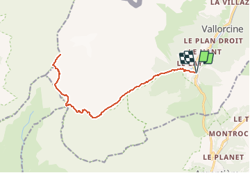
![](/images/other/stat-length.png)
![Tour Wandern Vallorcine - Trajet Salenton/ Le Buet - Photo](https://media.geolcdn.com/t/1900/400/f0f7a4ca-cb90-402a-bab0-71f2fb9dd7ed.jpg&format=pjpeg&maxdim=2)
Trajet Salenton/ Le Buet
Philindy26
Benutzer
![Länge](/images/other/stat-length.png)
![Maximale Höhe](https://static1.geolcdn.com/siteimages/upload/files/1508320355ic_sort_altitude_max_24dp.png)
![Positive Höhendifferenz](https://static1.geolcdn.com/siteimages/upload/files/1508320355ic_sort_den_pos_24dp.png)
![Km-Effort](/images/other/stat-length.png)
![Min. Höhe](https://static1.geolcdn.com/siteimages/upload/files/1508320355ic_sort_altitude_min_24dp.png)
![Negative Höhendifferenz](https://static1.geolcdn.com/siteimages/upload/files/1508320355ic_sort_den_neg_24dp.png)
![Boucle](https://static1.geolcdn.com/siteimages/upload/files/16400158638029165_repeat_loop_refresh_sync_direction_icon.png)
![Wandern](https://static1.geolcdn.com/sitytour/trail-icons/101.png)
8h30
Schwierigkeit : Sehr schwierig
![Scannen Sie diesen QR-Code, um die Tour in der SityTrail-Anwendung zu öffnen](https://capi.geolives.com/qq0zvz2zws4bq2lad0pu/sitytour/trails/2558360/qr.png?size=200)
Kostenlosegpshiking-Anwendung
Über SityTrail
Tour Wandern von 19,5 km verfügbar auf Auvergne-Rhone-Alpen, Hochsavoyen, Vallorcine. Diese Tour wird von Philindy26 vorgeschlagen.
Beschreibung
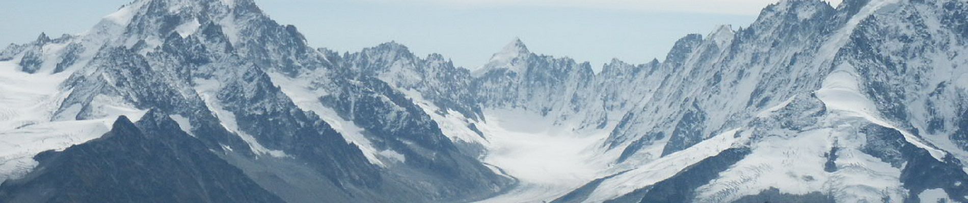
Le mont Buet est un sommet du massif du Giffre, en Haute-Savoie. Il est aussi appelé le « Mont Blanc des Dames »...
Départ du parking de Couteray au village du Buet - Vallorcine,
Géolocalisation du départ (Google Maps) : https://goo.gl/maps/pjPGVP4bQS2baVfg6 (46°01'08.2"N / 6°55'11.8"E ou 46.018934, 6.919949).
Prendre la direction du refuge de la Pierre à Bérard (1924 m), puis l'ascension sur le col de Salenton (2526 m) qui se termine par un pierré important.
Suivi d'un sentier de terre qui vous emmènera au pied de l'arête de la Mortine (2700 m). Après une montée raide, vous atteindrez l'abri de Pictet (3040 m).
Il ne reste que 59 m de dénivelé pour arriver au sommet à 3096 m d'altitude...
Le retour s'effectuera par le même chemin...
Ort
Kommentare
Touren in der Umgebung
![Tour Wandern Vallorcine - J18 - R17 - Col des Montets - Cascade de Bérard - Photo](https://media.geolcdn.com/t/375/260/e29e3f44-880b-4f2b-954e-82a481673653.jpg&format=jpg&maxdim=2)
![Wandern Wandern](https://static1.geolcdn.com/sitytour/trail-icons/101.png)
Wandern
![](/images/other/stat-length.png)
![](https://static1.geolcdn.com/siteimages/upload/files/16400158638029165_repeat_loop_refresh_sync_direction_icon.png)
![Tour Wandern Vallorcine - Le Buet - Vallorcine - Photo](https://media.geolcdn.com/t/375/260/ext.jpg?maxdim=2&url=https%3A%2F%2Fservices.sitytrail.com%2FGeolivesWS%2FDownloadMedia.ashx%3FTrailID%3D105027%26Media%3D8587_6.jpg)
![Wandern Wandern](https://static1.geolcdn.com/sitytour/trail-icons/101.png)
Wandern
![](/images/other/stat-length.png)
![](https://static1.geolcdn.com/siteimages/upload/files/16400158638029165_repeat_loop_refresh_sync_direction_icon.png)
![Tour Wandern Chamonix-Mont-Blanc - Aiguillette des Posettes 2201m 6.7.22 - Photo](https://media.geolcdn.com/t/375/260/920b5cab-549c-4a76-961b-08991dae2f72.jpg&format=jpg&maxdim=2)
![Wandern Wandern](https://static1.geolcdn.com/sitytour/trail-icons/101.png)
Wandern
![](/images/other/stat-length.png)
![](https://static1.geolcdn.com/siteimages/upload/files/16400158638029165_repeat_loop_refresh_sync_direction_icon.png)
![Tour Wintersport Vallorcine - vers Finhaut - Photo](https://media.geolcdn.com/t/375/260/ext.jpg?maxdim=2&url=https%3A%2F%2Fstatic1.geolcdn.com%2Fsiteimages%2Fupload%2Ffiles%2F1524743153ski.jpg)
![Wintersport Wintersport](https://static1.geolcdn.com/sitytour/trail-icons/500.png)
Wintersport
![](/images/other/stat-length.png)
![](https://static1.geolcdn.com/siteimages/upload/files/16400158638029165_repeat_loop_refresh_sync_direction_icon.png)
![Tour Wandern Vallorcine - J16 - R15 - Chemin des Diligences - Photo](https://media.geolcdn.com/t/375/260/3a598cc1-ce55-4b49-a436-a0cb45f4ed78.jpg&format=jpg&maxdim=2)
![Wandern Wandern](https://static1.geolcdn.com/sitytour/trail-icons/101.png)
Wandern
![](/images/other/stat-length.png)
![](https://static1.geolcdn.com/siteimages/upload/files/16400158638029165_repeat_loop_refresh_sync_direction_icon.png)
![Tour Wandern Chamonix-Mont-Blanc - Argentiere - Photo](https://media.geolcdn.com/t/375/260/fad04a40-7ca4-42c3-847b-c84c30515115.jpg&format=jpg&maxdim=2)
![Wandern Wandern](https://static1.geolcdn.com/sitytour/trail-icons/101.png)
Wandern
![](/images/other/stat-length.png)
![](https://static1.geolcdn.com/siteimages/upload/files/16400158638029165_repeat_loop_refresh_sync_direction_icon.png)
![Tour Wandern Vallorcine - Le tour des Aiguilles Rouges : J1 - Photo](https://media.geolcdn.com/t/375/260/fa753838-66a1-4d50-a490-aa852af9fab3.jpg&format=jpg&maxdim=2)
![Wandern Wandern](https://static1.geolcdn.com/sitytour/trail-icons/101.png)
Wandern
![](/images/other/stat-length.png)
![](https://static1.geolcdn.com/siteimages/upload/files/16400158638029165_repeat_loop_refresh_sync_direction_icon.png)
![Tour Wandern Chamonix-Mont-Blanc - J11 - R9 - Montroc - Le Tour - Petit Balcon Nord - Photo](https://media.geolcdn.com/t/375/260/8771054a-ae65-47b0-88d4-5ceb13dec7ec.jpg&format=jpg&maxdim=2)
![Wandern Wandern](https://static1.geolcdn.com/sitytour/trail-icons/101.png)
Wandern
![](/images/other/stat-length.png)
![](https://static1.geolcdn.com/siteimages/upload/files/16400158638029165_repeat_loop_refresh_sync_direction_icon.png)
![Tour Wandern Chamonix-Mont-Blanc - Randonnée dans la Vallée de Chamonix - Photo](https://media.geolcdn.com/t/375/260/1572227c-7039-4906-9929-df662ca33afb.jpg&format=jpg&maxdim=2)
![Wandern Wandern](https://static1.geolcdn.com/sitytour/trail-icons/101.png)
Wandern
![](/images/other/stat-length.png)
![](https://static1.geolcdn.com/siteimages/upload/files/16400158638029165_repeat_loop_refresh_sync_direction_icon.png)