![](/images/other/stat-length.png)
![Tour Wandern Zuydcoote - la dune Marchand Zuydcoote circuit par les dunes - Photo](https://media.geolcdn.com/t/1900/400/9dfc0394-11c7-463d-b48b-554c1019e57c.jpg&format=pjpeg&maxdim=2)
la dune Marchand Zuydcoote circuit par les dunes
lepompi
Benutzer
![Länge](/images/other/stat-length.png)
Länge
9,2 km
![Maximale Höhe](https://static1.geolcdn.com/siteimages/upload/files/1508320355ic_sort_altitude_max_24dp.png)
Maximale Höhe
16 m
![Positive Höhendifferenz](https://static1.geolcdn.com/siteimages/upload/files/1508320355ic_sort_den_pos_24dp.png)
Positive Höhendifferenz
55 m
![Km-Effort](/images/other/stat-length.png)
Km-Effort
9,9 km
![Min. Höhe](https://static1.geolcdn.com/siteimages/upload/files/1508320355ic_sort_altitude_min_24dp.png)
Min. Höhe
2 m
![Negative Höhendifferenz](https://static1.geolcdn.com/siteimages/upload/files/1508320355ic_sort_den_neg_24dp.png)
Negative Höhendifferenz
55 m
![Boucle](https://static1.geolcdn.com/siteimages/upload/files/16400158638029165_repeat_loop_refresh_sync_direction_icon.png)
Boucle
Ja
Erstellungsdatum :
2020-09-21 16:55:58.491
Letzte Änderung :
2020-09-21 17:05:57.682
![Wandern](https://static1.geolcdn.com/sitytour/trail-icons/101.png)
2h30
Schwierigkeit : Medium
![Scannen Sie diesen QR-Code, um die Tour in der SityTrail-Anwendung zu öffnen](https://capi.geolives.com/qq0zvz2zws4bq2lad0pu/sitytour/trails/2558274/qr.png?size=200)
Kostenlosegpshiking-Anwendung
Über SityTrail
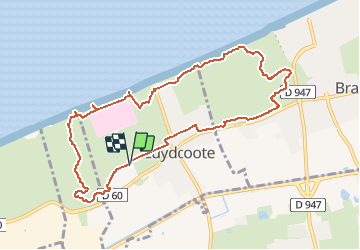
Tour Wandern von 9,2 km verfügbar auf Nordfrankreich, Nord, Zuydcoote. Diese Tour wird von lepompi vorgeschlagen.
Beschreibung
Renforcement muscles fessiers assuré!
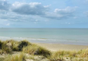
Propriétaires de chien:passage par les dunes car plage interdite aux chiens du 1 mai à fin septembre
Ort
Land:
France
Region :
Nordfrankreich
Abteilung/Provinz :
Nord
Kommune :
Zuydcoote
Standort:
Unknown
Gehen Sie:(Dec)
Gehen Sie:(UTM)
463729 ; 5656919 (31U) N.
Kommentare
Touren in der Umgebung
![Tour Wandern Ghyvelde - Circuit de la dune fossile - Photo](https://media.geolcdn.com/t/375/260/ext.jpg?maxdim=2&url=https%3A%2F%2Fservices.sitytrail.com%2FGeolivesWS%2FDownloadMedia.ashx%3FTrailID%3D202884%26Media%3De70f8078-3884-40d7-916d-9c1e8d1873d8.jpg)
![Wandern Wandern](https://static1.geolcdn.com/sitytour/trail-icons/101.png)
Circuit de la dune fossile
Wandern
Sehr leicht
(3)
Ghyvelde,
Nordfrankreich,
Nord,
France
![](/images/other/stat-length.png)
7,8 km | 8,4 km-effort
Unbekannt
![](https://static1.geolcdn.com/siteimages/upload/files/16400158638029165_repeat_loop_refresh_sync_direction_icon.png)
Ja
![Tour Wandern Zuydcoote - Circuit de l'Hôpital maritime - Zuydcoote - Photo](https://media.geolcdn.com/t/375/260/ext.jpg?maxdim=2&url=https%3A%2F%2Fservices.sitytrail.com%2FGeolivesWS%2FDownloadMedia.ashx%3FTrailID%3D109094%26Media%3D3144_6.jpg)
![Wandern Wandern](https://static1.geolcdn.com/sitytour/trail-icons/101.png)
Circuit de l'Hôpital maritime - Zuydcoote
Wandern
Einfach
(1)
Zuydcoote,
Nordfrankreich,
Nord,
France
![](/images/other/stat-length.png)
4,5 km | 4,9 km-effort
1h 15min
![](https://static1.geolcdn.com/siteimages/upload/files/16400158638029165_repeat_loop_refresh_sync_direction_icon.png)
Ja
![Tour Wandern Bray-Dunes - Gr5A Bray-Dunes / Nieuport - Photo](https://media.geolcdn.com/t/375/260/ext.jpg?maxdim=2&url=https%3A%2F%2Fstatic1.geolcdn.com%2Fsiteimages%2Fupload%2Ffiles%2F1553511878bg_sport_marche.png)
![Wandern Wandern](https://static1.geolcdn.com/sitytour/trail-icons/101.png)
Gr5A Bray-Dunes / Nieuport
Wandern
Medium
(1)
Bray-Dunes,
Nordfrankreich,
Nord,
France
![](/images/other/stat-length.png)
28 km | 31 km-effort
6h 56min
![](https://static1.geolcdn.com/siteimages/upload/files/16400158638029165_repeat_loop_refresh_sync_direction_icon.png)
Nein
![Tour Wandern Bray-Dunes - dune Marchand - Photo](https://media.geolcdn.com/t/375/260/ext.jpg?maxdim=2&url=https%3A%2F%2Fstatic1.geolcdn.com%2Fsiteimages%2Fupload%2Ffiles%2F1553511878bg_sport_marche.png)
![Wandern Wandern](https://static1.geolcdn.com/sitytour/trail-icons/101.png)
dune Marchand
Wandern
Medium
(1)
Bray-Dunes,
Nordfrankreich,
Nord,
France
![](/images/other/stat-length.png)
9,1 km | 9,8 km-effort
2h 30min
![](https://static1.geolcdn.com/siteimages/upload/files/16400158638029165_repeat_loop_refresh_sync_direction_icon.png)
Ja
![Tour Wandern Leffrinckoucke - La dune Dewulf à Leffrinckoucke - Photo](https://media.geolcdn.com/t/375/260/abe5025f-cfa7-4895-992a-7ecc6a041d70.jpeg&format=jpg&maxdim=2)
![Wandern Wandern](https://static1.geolcdn.com/sitytour/trail-icons/101.png)
La dune Dewulf à Leffrinckoucke
Wandern
Einfach
Leffrinckoucke,
Nordfrankreich,
Nord,
France
![](/images/other/stat-length.png)
5 km | 5,3 km-effort
1h 24min
![](https://static1.geolcdn.com/siteimages/upload/files/16400158638029165_repeat_loop_refresh_sync_direction_icon.png)
Ja
![Tour Zu Fuß Zuydcoote - Circuit de la dune Marchand - Zuydcoote - Photo](https://media.geolcdn.com/t/375/260/80639f4b-4b2c-4c13-bf37-87df4eff0893.jpeg&format=jpg&maxdim=2)
![Zu Fuß Zu Fuß](https://static1.geolcdn.com/sitytour/trail-icons/100.png)
Circuit de la dune Marchand - Zuydcoote
Zu Fuß
Einfach
Zuydcoote,
Nordfrankreich,
Nord,
France
![](/images/other/stat-length.png)
3,9 km | 4,2 km-effort
56min
![](https://static1.geolcdn.com/siteimages/upload/files/16400158638029165_repeat_loop_refresh_sync_direction_icon.png)
Nein
![Tour Wandern Zuydcoote - Circuit de la dune marchand - Photo](https://media.geolcdn.com/t/375/260/ext.jpg?maxdim=2&url=https%3A%2F%2Fservices.sitytrail.com%2FGeolivesWS%2FDownloadMedia.ashx%3FTrailID%3D202885%26Media%3D6557392e-0d70-4854-8070-e11053f0b96d.jpg)
![Wandern Wandern](https://static1.geolcdn.com/sitytour/trail-icons/101.png)
Circuit de la dune marchand
Wandern
Sehr leicht
Zuydcoote,
Nordfrankreich,
Nord,
France
![](/images/other/stat-length.png)
9,2 km | 10 km-effort
Unbekannt
![](https://static1.geolcdn.com/siteimages/upload/files/16400158638029165_repeat_loop_refresh_sync_direction_icon.png)
Ja
![Tour Mountainbike Uxem - Bois des Forts et Canal de Bergues à Coudekerque - Uxem - Photo](https://media.geolcdn.com/t/375/260/ext.jpg?maxdim=2&url=https%3A%2F%2Fservices.sitytrail.com%2FGeolivesWS%2FDownloadMedia.ashx%3FTrailID%3D129696%26Media%3D13233_3.jpg)
![Mountainbike Mountainbike](https://static1.geolcdn.com/sitytour/trail-icons/202.png)
Bois des Forts et Canal de Bergues à Coudekerque - Uxem
Mountainbike
Medium
(1)
Uxem,
Nordfrankreich,
Nord,
France
![](/images/other/stat-length.png)
31 km | 33 km-effort
1h 30min
![](https://static1.geolcdn.com/siteimages/upload/files/16400158638029165_repeat_loop_refresh_sync_direction_icon.png)
Ja
![Tour Fahrrad Ghyvelde - Circuit des Polders - Ghyvelde - Photo](https://media.geolcdn.com/t/375/260/ext.jpg?maxdim=2&url=https%3A%2F%2Fservices.sitytrail.com%2FGeolivesWS%2FDownloadMedia.ashx%3FTrailID%3D111981%26Media%3D9287_6.jpg)
![Fahrrad Fahrrad](https://static1.geolcdn.com/sitytour/trail-icons/200.png)
Circuit des Polders - Ghyvelde
Fahrrad
Medium
(1)
Ghyvelde,
Nordfrankreich,
Nord,
France
![](/images/other/stat-length.png)
37 km | 39 km-effort
2h 0min
![](https://static1.geolcdn.com/siteimages/upload/files/16400158638029165_repeat_loop_refresh_sync_direction_icon.png)
Ja