![](/images/other/stat-length.png)
![Tour Reiten Avessac - Journée Rando FFE 200920 - Photo](https://media.geolcdn.com/t/1900/400/d59376dc-8f69-4260-9e0b-13c207d014fe.jpg&format=pjpeg&maxdim=2)
Journée Rando FFE 200920
Sevie44
Benutzer
![Länge](/images/other/stat-length.png)
Länge
24 km
![Maximale Höhe](https://static1.geolcdn.com/siteimages/upload/files/1508320355ic_sort_altitude_max_24dp.png)
Maximale Höhe
77 m
![Positive Höhendifferenz](https://static1.geolcdn.com/siteimages/upload/files/1508320355ic_sort_den_pos_24dp.png)
Positive Höhendifferenz
326 m
![Km-Effort](/images/other/stat-length.png)
Km-Effort
28 km
![Min. Höhe](https://static1.geolcdn.com/siteimages/upload/files/1508320355ic_sort_altitude_min_24dp.png)
Min. Höhe
-4 m
![Negative Höhendifferenz](https://static1.geolcdn.com/siteimages/upload/files/1508320355ic_sort_den_neg_24dp.png)
Negative Höhendifferenz
327 m
![Boucle](https://static1.geolcdn.com/siteimages/upload/files/16400158638029165_repeat_loop_refresh_sync_direction_icon.png)
Boucle
Ja
Erstellungsdatum :
2020-09-20 07:18:21.883
Letzte Änderung :
2020-09-26 06:50:08.497
![Reiten](https://static1.geolcdn.com/sitytour/trail-icons/301.png)
3h20
Schwierigkeit : Einfach
![Scannen Sie diesen QR-Code, um die Tour in der SityTrail-Anwendung zu öffnen](https://capi.geolives.com/qq0zvz2zws4bq2lad0pu/sitytour/trails/2557095/qr.png?size=200)
Kostenlosegpshiking-Anwendung
Über SityTrail
Tour Reiten von 24 km verfügbar auf Pays de la Loire, Loire-Atlantique, Avessac. Diese Tour wird von Sevie44 vorgeschlagen.
Beschreibung
randonnée organisée par les écurie Thomazo au départ de leur installation
parcours facile
fait à 4 chevaux
Ort
Land:
France
Region :
Pays de la Loire
Abteilung/Provinz :
Loire-Atlantique
Kommune :
Avessac
Standort:
Unknown
Gehen Sie:(Dec)
Gehen Sie:(UTM)
571848 ; 5275647 (30T) N.
Kommentare
Touren in der Umgebung
![Tour Hybrid-Bike Redon - Redon Héric Jour 5 - Photo](https://media.geolcdn.com/t/375/260/a67d4a59-a0ad-40cb-bce3-092e3619fcf7.jpg&format=jpg&maxdim=2)
![Hybrid-Bike Hybrid-Bike](https://static1.geolcdn.com/sitytour/trail-icons/203.png)
Redon Héric Jour 5
Hybrid-Bike
Einfach
Redon,
Bretagne,
Ille-et-Vilaine,
France
![](/images/other/stat-length.png)
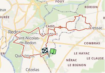
65 km | 71 km-effort
3h 19min
![](https://static1.geolcdn.com/siteimages/upload/files/16400158638029165_repeat_loop_refresh_sync_direction_icon.png)
Nein
![Tour Hybrid-Bike Redon - Etape 1 - Redon/Josselin - Photo](https://media.geolcdn.com/t/375/260/ext.jpg?maxdim=2&url=https%3A%2F%2Fstatic1.geolcdn.com%2Fsiteimages%2Fupload%2Ffiles%2F1524743154velo.jpg)
![Hybrid-Bike Hybrid-Bike](https://static1.geolcdn.com/sitytour/trail-icons/203.png)
Etape 1 - Redon/Josselin
Hybrid-Bike
Schwierig
(1)
Redon,
Bretagne,
Ille-et-Vilaine,
France
![](/images/other/stat-length.png)
68 km | 74 km-effort
Unbekannt
![](https://static1.geolcdn.com/siteimages/upload/files/16400158638029165_repeat_loop_refresh_sync_direction_icon.png)
Nein
![Tour Pferd Redon - La Vallée de l'Oust - Redon - Photo](https://media.geolcdn.com/t/375/260/ext.jpg?maxdim=2&url=https%3A%2F%2Fservices.sitytrail.com%2FGeolivesWS%2FDownloadMedia.ashx%3FTrailID%3D317600%26Media%3D16868_5.jpg)
![Pferd Pferd](https://static1.geolcdn.com/sitytour/trail-icons/300.png)
La Vallée de l'Oust - Redon
Pferd
Medium
Redon,
Bretagne,
Ille-et-Vilaine,
France
![](/images/other/stat-length.png)
16 km | 18,4 km-effort
2h 0min
![](https://static1.geolcdn.com/siteimages/upload/files/16400158638029165_repeat_loop_refresh_sync_direction_icon.png)
Nein
![Tour Wandern Redon - De la Belle Anguille au bois de Bahurel - Redon - Photo](https://media.geolcdn.com/t/375/260/ext.jpg?maxdim=2&url=https%3A%2F%2Fservices.sitytrail.com%2FGeolivesWS%2FDownloadMedia.ashx%3FTrailID%3D317496%26Media%3D16731_4.jpg)
![Wandern Wandern](https://static1.geolcdn.com/sitytour/trail-icons/101.png)
De la Belle Anguille au bois de Bahurel - Redon
Wandern
Schwierig
Redon,
Bretagne,
Ille-et-Vilaine,
France
![](/images/other/stat-length.png)
14,6 km | 17,1 km-effort
3h 45min
![](https://static1.geolcdn.com/siteimages/upload/files/16400158638029165_repeat_loop_refresh_sync_direction_icon.png)
Ja
![Tour Wandern Sainte-Marie - Circuit des Ardoisières - Sainte Marie - Photo](https://media.geolcdn.com/t/375/260/ext.jpg?maxdim=2&url=https%3A%2F%2Fservices.sitytrail.com%2FGeolivesWS%2FDownloadMedia.ashx%3FTrailID%3D111778%26Media%3D8285_4.jpg)
![Wandern Wandern](https://static1.geolcdn.com/sitytour/trail-icons/101.png)
Circuit des Ardoisières - Sainte Marie
Wandern
Medium
Sainte-Marie,
Bretagne,
Ille-et-Vilaine,
France
![](/images/other/stat-length.png)
11,2 km | 12,8 km-effort
2h 45min
![](https://static1.geolcdn.com/siteimages/upload/files/16400158638029165_repeat_loop_refresh_sync_direction_icon.png)
Ja
![Tour Wandern Avessac - Circuit des Saletin (10,5 km) - Avessac - Photo](https://media.geolcdn.com/t/375/260/ext.jpg?maxdim=2&url=https%3A%2F%2Fservices.sitytrail.com%2FGeolivesWS%2FDownloadMedia.ashx%3FTrailID%3D111705%26Media%3D8013_6.jpg)
![Wandern Wandern](https://static1.geolcdn.com/sitytour/trail-icons/101.png)
Circuit des Saletin (10,5 km) - Avessac
Wandern
Medium
Avessac,
Pays de la Loire,
Loire-Atlantique,
France
![](/images/other/stat-length.png)
10,5 km | 12,5 km-effort
2h 34min
![](https://static1.geolcdn.com/siteimages/upload/files/16400158638029165_repeat_loop_refresh_sync_direction_icon.png)
Ja
![Tour Wandern Avessac - Circuit des Saletin (7 km) - Avessac - Photo](https://media.geolcdn.com/t/375/260/ext.jpg?maxdim=2&url=https%3A%2F%2Fservices.sitytrail.com%2FGeolivesWS%2FDownloadMedia.ashx%3FTrailID%3D111636%26Media%3D7837_6.jpg)
![Wandern Wandern](https://static1.geolcdn.com/sitytour/trail-icons/101.png)
Circuit des Saletin (7 km) - Avessac
Wandern
Einfach
Avessac,
Pays de la Loire,
Loire-Atlantique,
France
![](/images/other/stat-length.png)
6,9 km | 8,4 km-effort
1h 45min
![](https://static1.geolcdn.com/siteimages/upload/files/16400158638029165_repeat_loop_refresh_sync_direction_icon.png)
Ja
![Tour Elektrofahrrad Redon - Redon à La roche-Bernard - Photo](https://media.geolcdn.com/t/375/260/39c51534-ab2b-4273-9c76-89e7ab0027f4.jpg&format=jpg&maxdim=2)
![Elektrofahrrad Elektrofahrrad](https://static1.geolcdn.com/sitytour/trail-icons/205.png)
Redon à La roche-Bernard
Elektrofahrrad
Medium
Redon,
Bretagne,
Ille-et-Vilaine,
France
![](/images/other/stat-length.png)
44 km | 50 km-effort
4h 57min
![](https://static1.geolcdn.com/siteimages/upload/files/16400158638029165_repeat_loop_refresh_sync_direction_icon.png)
Nein
![Tour Wandern Fégréac - 177 Rando le Bellion Pont Miny - Photo](https://media.geolcdn.com/t/375/260/32aa3fae-b050-4428-8fea-268a70b8c1b3.jpg&format=jpg&maxdim=2)
![Wandern Wandern](https://static1.geolcdn.com/sitytour/trail-icons/101.png)
177 Rando le Bellion Pont Miny
Wandern
Schwierig
Fégréac,
Pays de la Loire,
Loire-Atlantique,
France
![](/images/other/stat-length.png)
13,2 km | 14,9 km-effort
3h 9min
![](https://static1.geolcdn.com/siteimages/upload/files/16400158638029165_repeat_loop_refresh_sync_direction_icon.png)
Ja