![](/images/other/stat-length.png)
![Tour Wandern Allouville-Bellefosse - Allouville -Bellefosse - Photo](https://media.geolcdn.com/t/1900/400/48ea2f08-2bb6-4cc5-be17-998a80c9c4f7.jpg&format=pjpeg&maxdim=2)
Allouville -Bellefosse
MichelRando7656
Benutzer
![Länge](/images/other/stat-length.png)
Länge
10,3 km
![Maximale Höhe](https://static1.geolcdn.com/siteimages/upload/files/1508320355ic_sort_altitude_max_24dp.png)
Maximale Höhe
155 m
![Positive Höhendifferenz](https://static1.geolcdn.com/siteimages/upload/files/1508320355ic_sort_den_pos_24dp.png)
Positive Höhendifferenz
166 m
![Km-Effort](/images/other/stat-length.png)
Km-Effort
12,5 km
![Min. Höhe](https://static1.geolcdn.com/siteimages/upload/files/1508320355ic_sort_altitude_min_24dp.png)
Min. Höhe
55 m
![Negative Höhendifferenz](https://static1.geolcdn.com/siteimages/upload/files/1508320355ic_sort_den_neg_24dp.png)
Negative Höhendifferenz
167 m
![Boucle](https://static1.geolcdn.com/siteimages/upload/files/16400158638029165_repeat_loop_refresh_sync_direction_icon.png)
Boucle
Ja
Erstellungsdatum :
2020-09-20 11:47:33.104
Letzte Änderung :
2020-09-20 14:42:17.463
![Wandern](https://static1.geolcdn.com/sitytour/trail-icons/101.png)
2h52
Schwierigkeit : Schwierig
![Scannen Sie diesen QR-Code, um die Tour in der SityTrail-Anwendung zu öffnen](https://capi.geolives.com/qq0zvz2zws4bq2lad0pu/sitytour/trails/2556953/qr.png?size=200)
Kostenlosegpshiking-Anwendung
Über SityTrail
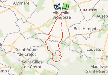
Tour Wandern von 10,3 km verfügbar auf Normandie, Seine-Maritime, Allouville-Bellefosse. Diese Tour wird von MichelRando7656 vorgeschlagen.
Beschreibung
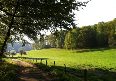
Promenade dans des sentiers le long des bois. Petites routes goudronnées au début et la fin du Parcours. Deux longues montées.
Ort
Land:
France
Region :
Normandie
Abteilung/Provinz :
Seine-Maritime
Kommune :
Allouville-Bellefosse
Standort:
Unknown
Gehen Sie:(Dec)
Gehen Sie:(UTM)
332155 ; 5496375 (31U) N.
Kommentare
Touren in der Umgebung
![Tour Wandern Allouville-Bellefosse - allouille bellefosse - Photo](https://media.geolcdn.com/t/375/260/ext.jpg?maxdim=2&url=https%3A%2F%2Fstatic1.geolcdn.com%2Fsiteimages%2Fupload%2Ffiles%2F1553511878bg_sport_marche.png)
![Wandern Wandern](https://static1.geolcdn.com/sitytour/trail-icons/101.png)
allouille bellefosse
Wandern
Sehr leicht
(2)
Allouville-Bellefosse,
Normandie,
Seine-Maritime,
France
![](/images/other/stat-length.png)
10,4 km | 12,6 km-effort
2h 30min
![](https://static1.geolcdn.com/siteimages/upload/files/16400158638029165_repeat_loop_refresh_sync_direction_icon.png)
Ja
![Tour Wandern Saint-Aubin-de-Crétot - St Aubin de Crétot - Photo](https://media.geolcdn.com/t/375/260/ext.jpg?maxdim=2&url=https%3A%2F%2Fservices.sitytrail.com%2FGeolivesWS%2FDownloadMedia.ashx%3FTrailID%3D107050%26Media%3D11860_1.jpg)
![Wandern Wandern](https://static1.geolcdn.com/sitytour/trail-icons/101.png)
St Aubin de Crétot
Wandern
Medium
Saint-Aubin-de-Crétot,
Normandie,
Seine-Maritime,
France
![](/images/other/stat-length.png)
17,8 km | 23 km-effort
3h 40min
![](https://static1.geolcdn.com/siteimages/upload/files/16400158638029165_repeat_loop_refresh_sync_direction_icon.png)
Nein
![Tour Wandern Allouville-Bellefosse - Allouville Bellefosse 25/08/2024 - Photo](https://media.geolcdn.com/t/375/260/ext.jpg?maxdim=2&url=https%3A%2F%2Fstatic1.geolcdn.com%2Fsiteimages%2Fupload%2Ffiles%2F1553511878bg_sport_marche.png)
![Wandern Wandern](https://static1.geolcdn.com/sitytour/trail-icons/101.png)
Allouville Bellefosse 25/08/2024
Wandern
Schwierig
Allouville-Bellefosse,
Normandie,
Seine-Maritime,
France
![](/images/other/stat-length.png)
10,6 km | 12,8 km-effort
2h 54min
![](https://static1.geolcdn.com/siteimages/upload/files/16400158638029165_repeat_loop_refresh_sync_direction_icon.png)
Ja
![Tour Moto-Cross Terres-de-Caux - 21032021 Bermonville Hericourt en caux - Photo](https://media.geolcdn.com/t/375/260/ext.jpg?maxdim=2&url=https%3A%2F%2Fstatic1.geolcdn.com%2Fsiteimages%2Fupload%2Ffiles%2F1524743155moto.jpg)
![Moto-Cross Moto-Cross](https://static1.geolcdn.com/sitytour/trail-icons/406.png)
21032021 Bermonville Hericourt en caux
Moto-Cross
Sehr leicht
Terres-de-Caux,
Normandie,
Seine-Maritime,
France
![](/images/other/stat-length.png)
73 km | 85 km-effort
2h 2min
![](https://static1.geolcdn.com/siteimages/upload/files/16400158638029165_repeat_loop_refresh_sync_direction_icon.png)
Ja
![Tour Zu Fuß Saint-Gilles-de-Crétot - Saint Gilles de Crétot - Photo](https://media.geolcdn.com/t/375/260/ext.jpg?maxdim=2&url=https%3A%2F%2Fstatic1.geolcdn.com%2Fsiteimages%2Fupload%2Ffiles%2F1545311037marcheuse_200dpi.jpg)
![Zu Fuß Zu Fuß](https://static1.geolcdn.com/sitytour/trail-icons/100.png)
Saint Gilles de Crétot
Zu Fuß
Einfach
Saint-Gilles-de-Crétot,
Normandie,
Seine-Maritime,
France
![](/images/other/stat-length.png)
6,1 km | 7,5 km-effort
1h 30min
![](https://static1.geolcdn.com/siteimages/upload/files/16400158638029165_repeat_loop_refresh_sync_direction_icon.png)
Ja
![Tour Zu Fuß Allouville-Bellefosse - Le Chêne d'Allouville - Photo](https://media.geolcdn.com/t/375/260/ext.jpg?maxdim=2&url=https%3A%2F%2Fstatic1.geolcdn.com%2Fsiteimages%2Fupload%2Ffiles%2F1545311037marcheuse_200dpi.jpg)
![Zu Fuß Zu Fuß](https://static1.geolcdn.com/sitytour/trail-icons/100.png)
Le Chêne d'Allouville
Zu Fuß
Einfach
Allouville-Bellefosse,
Normandie,
Seine-Maritime,
France
![](/images/other/stat-length.png)
10,2 km | 11,9 km-effort
2h 30min
![](https://static1.geolcdn.com/siteimages/upload/files/16400158638029165_repeat_loop_refresh_sync_direction_icon.png)
Ja
![Tour Andere Aktivitäten Allouville-Bellefosse - 20180517-Allouville Bellefosse - Photo](https://media.geolcdn.com/t/375/260/ext.jpg?maxdim=2&url=https%3A%2F%2Fstatic1.geolcdn.com%2Fsiteimages%2Fupload%2Ffiles%2F1545311037marcheuse_200dpi.jpg)
![Andere Aktivitäten Andere Aktivitäten](https://static1.geolcdn.com/sitytour/trail-icons/900.png)
20180517-Allouville Bellefosse
Andere Aktivitäten
Sehr leicht
Allouville-Bellefosse,
Normandie,
Seine-Maritime,
France
![](/images/other/stat-length.png)
19,4 km | 23 km-effort
6h 0min
![](https://static1.geolcdn.com/siteimages/upload/files/16400158638029165_repeat_loop_refresh_sync_direction_icon.png)
Ja
![Tour Wandern Allouville-Bellefosse - Allouville Bellefosse - Photo](https://media.geolcdn.com/t/375/260/ext.jpg?maxdim=2&url=https%3A%2F%2Fstatic1.geolcdn.com%2Fsiteimages%2Fupload%2Ffiles%2F1553511878bg_sport_marche.png)
![Wandern Wandern](https://static1.geolcdn.com/sitytour/trail-icons/101.png)
Allouville Bellefosse
Wandern
Einfach
Allouville-Bellefosse,
Normandie,
Seine-Maritime,
France
![](/images/other/stat-length.png)
10,7 km | 12,5 km-effort
2h 45min
![](https://static1.geolcdn.com/siteimages/upload/files/16400158638029165_repeat_loop_refresh_sync_direction_icon.png)
Ja
![Tour Motor Saint-Aubin-de-Crétot - Normandie - Photo](https://media.geolcdn.com/t/375/260/ext.jpg?maxdim=2&url=https%3A%2F%2Fstatic1.geolcdn.com%2Fsiteimages%2Fupload%2Ffiles%2F15247431544x4.jpg)
![Motor Motor](https://static1.geolcdn.com/sitytour/trail-icons/400.png)
Normandie
Motor
Sehr leicht
(1)
Saint-Aubin-de-Crétot,
Normandie,
Seine-Maritime,
France
![](/images/other/stat-length.png)
156 km | 199 km-effort
5min
![](https://static1.geolcdn.com/siteimages/upload/files/16400158638029165_repeat_loop_refresh_sync_direction_icon.png)
Ja